Enable Location

We need your location to show you interesting places around you

Discover nearby places

Find interesting locations and hidden gems around you

Precise directions

Get accurate directions and distances to places

Your location is never shared with other users. It's only used when you tap the location button.

Bohemian Flats

Log in to your account

Start exploring — it's free

Trusted by 65,811 travelers worldwide

Continue with Google
Continue with Apple
or

We will send you a code to connect

By continuing, you accept our Terms and Conditions and our Privacy Policy

Check your inbox

We've sent a pincode in your inbox. Please enter the code below.

Bohemian Flats
Discussion Reviews 1 Photos
6.5k Popularity

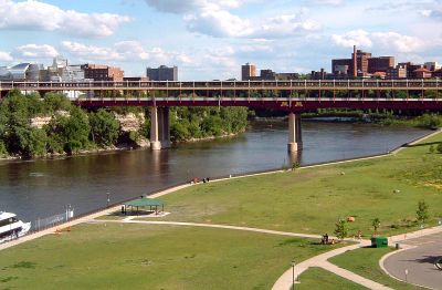
Bohemian Flats, Historic residential site along Mississippi River in Minneapolis, United States.

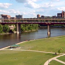
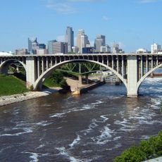
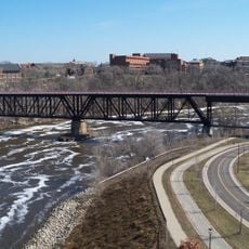
Bohemian Flats is a historic site along the Mississippi River in Minneapolis, now a riverfront park sitting directly beneath the Washington Avenue Bridge near the University of Minnesota. The flat, open ground along the water includes picnic tables, canoe racks, and restroom facilities.

Starting in the 1880s, immigrant families settled on this low floodplain and worked in the mills nearby, forming one of Minneapolis's most densely packed riverside neighborhoods. By the 1940s, the city cleared the area to make way for the Washington Avenue Bridge.

The name Bohemian Flats comes from the Czech and Slovak settlers who were among the first to occupy this low stretch of riverbank and gave it its informal identity. Today visitors come to picnic, launch canoes, or simply sit by the water where those households once stood.

The park is easy to reach on foot from the University of Minnesota and sits right on the riverbank, so the ground near the water can be slippery after rain. Sturdy shoes are a good idea, especially if you plan to use the canoe launch or walk close to the water's edge.

The houses built here had no fixed foundations, which meant the whole neighborhood flooded every spring and families moved out temporarily each year before returning once the water dropped. Some households simply floated their belongings out and waited on higher ground until the river retreated.

The community of curious travelers

AroundUs brings together thousands of curated places, local tips, and hidden gems, enriched daily by 60,000 contributors worldwide.

Start exploring
Location
GPS coordinates
44.97530,-93.24140
Latest update
March 3, 2026 10:10
Around this place
Weisman Art Museum
United States of America

Weisman Art Museum

385 m
I-35W Saint Anthony Falls Bridge
United States of America

I-35W Saint Anthony Falls Bridge

490 m
Riverside Plaza
United States of America

Riverside Plaza

835 m
Memorial Stadium
United States of America

Memorial Stadium

1 km
Washington Avenue Bridge
United States of America

Washington Avenue Bridge

296 m
Northrop Auditorium
United States of America

Northrop Auditorium

488 m
University of Minnesota Old Campus Historic District
United States of America

University of Minnesota Old Campus Historic District

499 m
Rarig Center
United States of America

Rarig Center

549 m
Coffman Memorial Union
United States of America

Coffman Memorial Union

554 m
University of Minnesota Armory
United States of America

University of Minnesota Armory

746 m
10th Avenue Bridge
United States of America

10th Avenue Bridge

445 m
Mixed Blood Theatre Company
United States of America

Mixed Blood Theatre Company

795 m
Malcom Moos Health Sciences Tower
United States of America

Malcom Moos Health Sciences Tower

818 m
Northern Pacific Bridge Number 9
United States of America

Northern Pacific Bridge Number 9

246 m
Walter Library
United States of America

Walter Library

417 m
Jean-Nickolaus Tretter Collection in Gay, Lesbian, Bisexual and Transgender Studies
United States of America

Jean-Nickolaus Tretter Collection in Gay, Lesbian, Bisexual and Transgender Studies

273 m
Gold Medal Park
United States of America

Gold Medal Park

953 m
The Cedar Cultural Center
United States of America

The Cedar Cultural Center

814 m
Dania Hall
United States of America

Dania Hall

824 m
Katherine E. Nash Gallery
United States of America

Katherine E. Nash Gallery

682 m
Southern Theater
United States of America

Southern Theater

568 m
Arvonne Fraser Library
United States of America

Arvonne Fraser Library

679 m
Phi Gamma Delta Fraternity House
United States of America

Phi Gamma Delta Fraternity House

670 m
United States of America

University of Minnesota Aquatic Center

964 m
Grace Evangelical Lutheran Church
United States of America

Grace Evangelical Lutheran Church

899 m
B. O. Cutter House
United States of America

B. O. Cutter House

835 m
Varsity Theater
United States of America

Varsity Theater

687 m
Cedar Theatre
United States of America

Cedar Theatre

817 m
Show the full map
Reviews
Share your experience

No review yet

Discussions
Start a discussion...

No discussion yet

« Bohemian Flats - Historic residential site along Mississippi River in Minneapolis, United States » is provided by Around Us (aroundus.com). Images and texts are derived from Wikimedia project under a Creative Commons license. You are allowed to copy, distribute, and modify copies of this page, under the conditions set by the license, as long as this note is clearly visible.

Discover hidden gems everywhere you go!

From secret cafés to breathtaking viewpoints, skip the crowded tourist spots and find places that match your style. Our app makes it easy with voice search, smart filtering, route optimization, and insider tips from travelers worldwide. Download now for the complete mobile experience.

Around Us App Screenshot

A unique approach to discovering new places

Le Figaro

All the places worth exploring

France Info

A tailor-made excursion in just a few clicks

20 Minutes

Around Us
Travel Guide & Maps
Download

Send to your phone

QR Code
1

Open the camera app on your mobile.

2

Point at the QR code with your camera. A notification will appear.

3

Tap the notification to open the link.