Enable Location

We need your location to show you interesting places around you

Discover nearby places

Find interesting locations and hidden gems around you

Precise directions

Get accurate directions and distances to places

Your location is never shared with other users. It's only used when you tap the location button.

Prospect Park Water Tower

Log in to your account

Start exploring — it's free

Trusted by 62,936 travelers worldwide

Continue with Google
Continue with Apple
or

We will send you a code to connect

By continuing, you accept our Terms and Conditions and our Privacy Policy

Check your inbox

We've sent a pincode in your inbox. Please enter the code below.

Prospect Park Water Tower
Discussion Reviews 1 Photos
6.8k Popularity

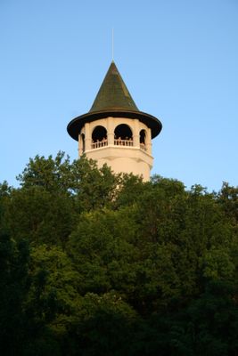
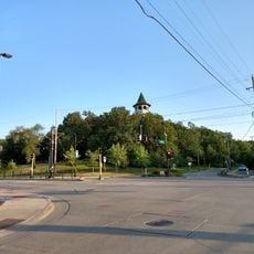
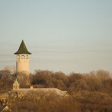
Prospect Park Water Tower, Water tower in Prospect Park neighborhood, Minneapolis, United States

The Prospect Park Water Tower is a historic water storage building in Minneapolis designed to supply the city's firefighting systems. The structure features a distinctive green ceramic tile cap and rises prominently above Tower Hill Park.

Frederick William Cappelen designed this structure in 1913 as Minneapolis expanded its water infrastructure network. The building served its original purpose until 1952 when changing technologies made it obsolete.

The tower stands as a local landmark that residents have come to identify with their neighborhood over the decades. It represents the practical ingenuity that shaped early city infrastructure.

The tower is visible from the park grounds and can be viewed from various angles throughout Tower Hill Park. Daytime visits work best for seeing the details and appreciating its position in the landscape.

The structure was initially conceived as a performance pavilion but this idea was abandoned after access challenges made it impractical for musicians. Early planners discovered that reaching the elevated space posed difficulties they had not anticipated.

The community of curious travelers

AroundUs brings together thousands of curated places, local tips, and hidden gems, enriched daily by 60,000 contributors worldwide.

Start exploring
Location
Operator
Minneapolis Park Board
GPS coordinates
44.96868,-93.21267
Latest update
December 9, 2025 18:41
Around this place
Huntington Bank Stadium
United States of America

Huntington Bank Stadium

1.3 km
Weisman Art Museum
United States of America

Weisman Art Museum

2.1 km
Memorial Stadium
United States of America

Memorial Stadium

1.5 km
Washington Avenue Bridge
United States of America

Washington Avenue Bridge

2.2 km
Northrop Auditorium
United States of America

Northrop Auditorium

2 km
Bell Museum of Natural History
United States of America

Bell Museum of Natural History

1.9 km
Malcolm Willey House
United States of America

Malcolm Willey House

973 m
University of Minnesota Old Campus Historic District
United States of America

University of Minnesota Old Campus Historic District

2.2 km
Coffman Memorial Union
United States of America

Coffman Memorial Union

1.8 km
University of Minnesota Armory
United States of America

University of Minnesota Armory

1.8 km
Malcom Moos Health Sciences Tower
United States of America

Malcom Moos Health Sciences Tower

1.6 km
Walter Library
United States of America

Walter Library

2 km
Short Line Bridge
United States of America

Short Line Bridge

1.4 km
Franklin Avenue Bridge
United States of America

Franklin Avenue Bridge

959 m
Meeker Island Lock and Dam
United States of America

Meeker Island Lock and Dam

1.7 km
Norway Lutheran Church
United States of America

Norway Lutheran Church

2.2 km
Dartmouth Bridge
United States of America

Dartmouth Bridge

1.1 km
Oak Street Cinema
United States of America

Oak Street Cinema

1.2 km
St. Anthony Park Branch Library
United States of America

St. Anthony Park Branch Library

2 km
Old Main
United States of America

Old Main

2.3 km
Tower Hill Park
United States of America

Tower Hill Park

15 m
United States of America

University of Minnesota Aquatic Center

1.5 km
Milton Square
United States of America

Milton Square

2 km
Grace Evangelical Lutheran Church
United States of America

Grace Evangelical Lutheran Church

1.5 km
Andrew R. McGill House
United States of America

Andrew R. McGill House

1.9 km
Luxton Park
United States of America

Luxton Park

500 m
Murphy Square
United States of America

Murphy Square

2.2 km
Prospect Park Residential Historic District
United States of America

Prospect Park Residential Historic District

286 m
Show the full map
Reviews
Share your experience

No review yet

Discussions
Start a discussion...

No discussion yet

« Prospect Park Water Tower - Water tower in Prospect Park neighborhood, Minneapolis, United States » is provided by Around Us (aroundus.com). Images and texts are derived from Wikimedia project under a Creative Commons license. You are allowed to copy, distribute, and modify copies of this page, under the conditions set by the license, as long as this note is clearly visible.

Discover hidden gems everywhere you go!

From secret cafés to breathtaking viewpoints, skip the crowded tourist spots and find places that match your style. Our app makes it easy with voice search, smart filtering, route optimization, and insider tips from travelers worldwide. Download now for the complete mobile experience.

Around Us App Screenshot

A unique approach to discovering new places

Le Figaro

All the places worth exploring

France Info

A tailor-made excursion in just a few clicks

20 Minutes

Around Us
Travel Guide & Maps
Download

Send to your phone

QR Code
1

Open the camera app on your mobile.

2

Point at the QR code with your camera. A notification will appear.

3

Tap the notification to open the link.