Enable Location

We need your location to show you interesting places around you

Discover nearby places

Find interesting locations and hidden gems around you

Precise directions

Get accurate directions and distances to places

Your location is never shared with other users. It's only used when you tap the location button.

Meeker Island Lock and Dam

Log in to your account

Start exploring — it's free

Trusted by 62,938 travelers worldwide

Continue with Google
Continue with Apple
or

We will send you a code to connect

By continuing, you accept our Terms and Conditions and our Privacy Policy

Check your inbox

We've sent a pincode in your inbox. Please enter the code below.

Discussion Reviews 1 Photos
2.3k Popularity

Meeker Island Lock and Dam, Historic lock and dam site along Mississippi River in Minneapolis and Saint Paul, United States

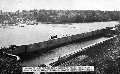
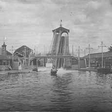
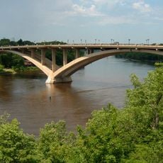
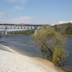
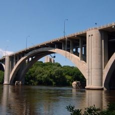
Meeker Island Lock and Dam is a historic lock and dam on the Mississippi River between Minneapolis and Saint Paul with stone foundations and concrete structures still visible today. These remnants become clearer when water levels in the river drop.

The facility was built between 1899 and 1907 as the first lock and dam on the Upper Mississippi, opening the river to northern navigation. It operated for just five years before closing in 1912.

The site represents economic competition between Minneapolis and Saint Paul over control of Mississippi River commerce and navigation. This rivalry shaped how both cities developed along the waterway.

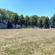
The remains are accessible through Mississippi River Gorge Regional Park, which has trails and interpretive signs explaining the structure. The best time to explore is during low water periods when more of the old foundations are visible.

The site was added to the National Register of Historic Places in 2003, after its historical importance had long been overlooked. This designation marks where river navigation first extended north of Saint Paul.

The community of curious travelers

AroundUs brings together thousands of curated places, local tips, and hidden gems, enriched daily by 60,000 contributors worldwide.

Start exploring
Location
Location
Architects
United States Army Corps of Engineers
GPS coordinates
44.95390,-93.20780
Latest update
December 13, 2025 12:41
Around this place
Malcolm Willey House
United States of America

Malcolm Willey House

727 m
Prospect Park Water Tower
United States of America

Prospect Park Water Tower

1.7 km
Milwaukee Avenue Historic District
United States of America

Milwaukee Avenue Historic District

2.7 km
O'Shaughnessy Stadium
United States of America

O'Shaughnessy Stadium

1.7 km
Wonderland Amusement Park
United States of America

Wonderland Amusement Park

1.6 km
Eastcliff
United States of America

Eastcliff

1.1 km
Martin Olav Sabo Bridge
United States of America

Martin Olav Sabo Bridge

2.7 km
Lake Street-Marshall Bridge
United States of America

Lake Street-Marshall Bridge

741 m
American Museum of Asmat Art
United States of America

American Museum of Asmat Art

1.9 km
Short Line Bridge
United States of America

Short Line Bridge

463 m
Franklin Avenue Bridge
United States of America

Franklin Avenue Bridge

1.6 km
Twin City Model Railroad Museum
United States of America

Twin City Model Railroad Museum

1.9 km
East Lake Library
United States of America

East Lake Library

1.8 km
Dr. Ward Beebe House
United States of America

Dr. Ward Beebe House

2.2 km
Triune Masonic Temple
United States of America

Triune Masonic Temple

2.2 km
Dartmouth Bridge
United States of America

Dartmouth Bridge

2 km
Tower Hill Park
United States of America

Tower Hill Park

1.7 km
Charles Thompson Memorial Hall
United States of America

Charles Thompson Memorial Hall

2.5 km
Grace Evangelical Lutheran Church
United States of America

Grace Evangelical Lutheran Church

2.8 km
Dickerman Park
United States of America

Dickerman Park

2.7 km
Krank Manufacturing Company building
United States of America

Krank Manufacturing Company building

2.3 km
White Sand Beach
United States of America

White Sand Beach

224 m
Luxton Park
United States of America

Luxton Park

1.8 km
Longfellow Park
United States of America

Longfellow Park

1.7 km
Murphy Square
United States of America

Murphy Square

2.8 km
Mississippi Gorge Park
United States of America

Mississippi Gorge Park

2.3 km
El Lago Theatre
United States of America

El Lago Theatre

1.2 km
Prospect Park Residential Historic District
United States of America

Prospect Park Residential Historic District

1.4 km
Show the full map
Reviews
Share your experience

No review yet

Discussions
Start a discussion...

No discussion yet

« Meeker Island Lock and Dam - Historic lock and dam site along Mississippi River in Minneapolis and Saint Paul, United States » is provided by Around Us (aroundus.com). Images and texts are derived from Wikimedia project under a Creative Commons license. You are allowed to copy, distribute, and modify copies of this page, under the conditions set by the license, as long as this note is clearly visible.

Discover hidden gems everywhere you go!

From secret cafés to breathtaking viewpoints, skip the crowded tourist spots and find places that match your style. Our app makes it easy with voice search, smart filtering, route optimization, and insider tips from travelers worldwide. Download now for the complete mobile experience.

Around Us App Screenshot

A unique approach to discovering new places

Le Figaro

All the places worth exploring

France Info

A tailor-made excursion in just a few clicks

20 Minutes

Around Us
Travel Guide & Maps
Download

Send to your phone

QR Code
1

Open the camera app on your mobile.

2

Point at the QR code with your camera. A notification will appear.

3

Tap the notification to open the link.