Enable Location

We need your location to show you interesting places around you

Discover nearby places

Find interesting locations and hidden gems around you

Precise directions

Get accurate directions and distances to places

Your location is never shared with other users. It's only used when you tap the location button.

Milwaukee Avenue Historic District

Log in to your account

Start exploring — it's free

Trusted by 61,506 travelers worldwide

Continue with Google
Continue with Apple
or

We will send you a code to connect

By continuing, you accept our Terms and Conditions and our Privacy Policy

Check your inbox

We've sent a pincode in your inbox. Please enter the code below.

Milwaukee Avenue Historic District, Historic district in Seward neighborhood, Minneapolis, United States

Description

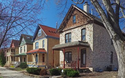
Milwaukee Avenue Historic District is a residential area containing 78 Victorian brick houses built with matching designs on small quarter-lot parcels. Each house features wooden porches and ornamental details that show how residents lived during the late 1800s.

History

William Ragan developed this residential area in 1883, building approximately 46 uniform houses as affordable housing for railroad workers. The area gradually expanded over the following decades as more Victorian-style homes were added.

Culture

The district grew from a Scandinavian immigrant settlement and attracted professors, students, and artists starting in the 1960s. You can still feel this mix of backgrounds in how residents have personalized their homes and use the shared spaces.

Practical

The best way to experience the area is with a slow walk along the street to notice the details of each house. The paved walkways are easy to navigate and allow you to enjoy the neighborhood at your own pace.

Did you know?

Local residents successfully fought against demolition plans in the 1970s and saved these houses from being torn down. The street was then transformed into a pedestrian-only area, fundamentally changing how people experience the place.

Location
GPS coordinates
44.96083,-93.24000
Latest update
December 10, 2025 16:29

AroundUs brings together thousands of curated places, local tips, and hidden gems, enriched daily by 60,000 contributors worldwide. Discover all places nearby (Minnesota).

Around this place
Weisman Art Museum
United States of America

Weisman Art Museum

1.3 km
Riverside Plaza
United States of America

Riverside Plaza

1.2 km
Bethlehem Baptist Church
United States of America

Bethlehem Baptist Church

1.5 km
Washington Avenue Bridge
United States of America

Washington Avenue Bridge

1.4 km
Bohemian Flats
United States of America

Bohemian Flats

1.6 km
Triple Rock Social Club
United States of America

Triple Rock Social Club

868 m
Rarig Center
United States of America

Rarig Center

1.1 km
Coffman Memorial Union
United States of America

Coffman Memorial Union

1.4 km
Martin Olav Sabo Bridge
United States of America

Martin Olav Sabo Bridge

711 m
Mixed Blood Theatre Company
United States of America

Mixed Blood Theatre Company

1.3 km
Malcom Moos Health Sciences Tower
United States of America

Malcom Moos Health Sciences Tower

1.5 km
Walter Library
United States of America

Walter Library

1.6 km
Jean-Nickolaus Tretter Collection in Gay, Lesbian, Bisexual and Transgender Studies
United States of America

Jean-Nickolaus Tretter Collection in Gay, Lesbian, Bisexual and Transgender Studies

1.4 km
Franklin Avenue Bridge
United States of America

Franklin Avenue Bridge

1.4 km
The Cedar Cultural Center
United States of America

The Cedar Cultural Center

1.1 km
Dania Hall
United States of America

Dania Hall

1.1 km
Katherine E. Nash Gallery
United States of America

Katherine E. Nash Gallery

947 m
Southern Theater
United States of America

Southern Theater

1.5 km
East Lake Library
United States of America

East Lake Library

1.6 km
511 Building
United States of America

511 Building

1.7 km
Franklin Library
United States of America

Franklin Library

1.3 km
Dartmouth Bridge
United States of America

Dartmouth Bridge

1.2 km
Old Main
United States of America

Old Main

572 m
Grace Evangelical Lutheran Church
United States of America

Grace Evangelical Lutheran Church

1.5 km
挪威路德会纪念教堂 (明尼阿波利斯)
United States of America

挪威路德会纪念教堂 (明尼阿波利斯)

1.6 km
Cedar Theatre
United States of America

Cedar Theatre

1.1 km
Murphy Square
United States of America

Murphy Square

496 m
Minnehaha Center
United States of America

Minnehaha Center

1.2 km
Show the full map
« Milwaukee Avenue Historic District - Historic district in Seward neighborhood, Minneapolis, United States » is provided by Around Us (aroundus.com). Images and texts are derived from Wikimedia project under a Creative Commons license. You are allowed to copy, distribute, and modify copies of this page, under the conditions set by the license, as long as this note is clearly visible.

Discover hidden gems everywhere you go!

From secret cafés to breathtaking viewpoints, skip the crowded tourist spots and find places that match your style. Our app makes it easy with voice search, smart filtering, route optimization, and insider tips from travelers worldwide. Download now for the complete mobile experience.

Around Us App Screenshot

A unique approach to discovering new places

Le Figaro

All the places worth exploring

France Info

A tailor-made excursion in just a few clicks

20 Minutes

Around Us
Travel Guide & Maps
Download

Send to your phone

QR Code
1

Open the camera app on your mobile.

2

Point at the QR code with your camera. A notification will appear.

3

Tap the notification to open the link.