Enable Location

We need your location to show you interesting places around you

Discover nearby places

Find interesting locations and hidden gems around you

Precise directions

Get accurate directions and distances to places

Your location is never shared with other users. It's only used when you tap the location button.

Short Line Bridge

Log in to your account

Start exploring — it's free

Trusted by 61,508 travelers worldwide

Continue with Google
Continue with Apple
or

We will send you a code to connect

By continuing, you accept our Terms and Conditions and our Privacy Policy

Check your inbox

We've sent a pincode in your inbox. Please enter the code below.

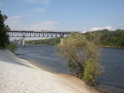
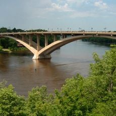
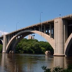
Short Line Bridge, Railway bridge in South Minneapolis, United States

Description

The Short Line Bridge is a steel structure spanning the Mississippi River that serves modern rail traffic between the two cities. The bridge uses a truss design and today handles grain and freight transport along the Hiawatha Avenue corridor.

History

The structure was built in 1902 as a replacement for an older bridge from 1880 and was part of the Chicago, Milwaukee and St. Paul Railway expansion. With this new connection, rail lines finally had a direct route without lengthy detours through Fort Snelling.

Culture

The bridge links Minneapolis and St. Paul with a direct railway route that freed trains from a lengthy detour. Today it shapes the riverbank landscape and shows how important rail transport was to the region's growth.

Practical

The bridge is best viewed from riverbank walkways or rail observation points, as direct access is limited. Visitors should note that active train traffic uses the bridge several times per week, so it is safest to watch from a distance.

Did you know?

The construction used an innovative pulley system that let workers replace parts without stopping train operations. This technique was pioneering for its time and showed early practices for maintenance without service interruptions.

Location
Official opening
1902
Part of
Minnesota Commercial Railway
GPS coordinates
44.95640,-93.21250
Latest update
December 12, 2025 17:45

AroundUs brings together thousands of curated places, local tips, and hidden gems, enriched daily by 60,000 contributors worldwide. Discover all places nearby (Minneapolis).

Around this place
Huntington Bank Stadium
United States of America

Huntington Bank Stadium

2.4 km
Memorial Stadium
United States of America

Memorial Stadium

2.5 km
Malcolm Willey House
United States of America

Malcolm Willey House

537 m
Prospect Park Water Tower
United States of America

Prospect Park Water Tower

1.4 km
Milwaukee Avenue Historic District
United States of America

Milwaukee Avenue Historic District

2.2 km
O'Shaughnessy Stadium
United States of America

O'Shaughnessy Stadium

2.2 km
Riverview Theater
United States of America

Riverview Theater

2.5 km
Eastcliff
United States of America

Eastcliff

1.6 km
Martin Olav Sabo Bridge
United States of America

Martin Olav Sabo Bridge

2.4 km
Malcom Moos Health Sciences Tower
United States of America

Malcom Moos Health Sciences Tower

2.4 km
Lake Street-Marshall Bridge
United States of America

Lake Street-Marshall Bridge

1.2 km
Trylon Cinema
United States of America

Trylon Cinema

2.1 km
American Museum of Asmat Art
United States of America

American Museum of Asmat Art

2.3 km
Franklin Avenue Bridge
United States of America

Franklin Avenue Bridge

1.2 km
Meeker Island Lock and Dam
United States of America

Meeker Island Lock and Dam

463 m
Twin City Model Railroad Museum
United States of America

Twin City Model Railroad Museum

2.2 km
East Lake Library
United States of America

East Lake Library

1.5 km
Dartmouth Bridge
United States of America

Dartmouth Bridge

1.5 km
Oak Street Cinema
United States of America

Oak Street Cinema

2.2 km
Tower Hill Park
United States of America

Tower Hill Park

1.4 km
United States of America

University of Minnesota Aquatic Center

2.5 km
Grace Evangelical Lutheran Church
United States of America

Grace Evangelical Lutheran Church

2.3 km
Luxton Park
United States of America

Luxton Park

1.4 km
Longfellow Park
United States of America

Longfellow Park

1.8 km
El Lago Theatre
United States of America

El Lago Theatre

1.1 km
Murphy Square
United States of America

Murphy Square

2.4 km
Prospect Park Residential Historic District
United States of America

Prospect Park Residential Historic District

1.1 km
Minnehaha Center
United States of America

Minnehaha Center

2 km
Show the full map
« Short Line Bridge - Railway bridge in South Minneapolis, United States » is provided by Around Us (aroundus.com). Images and texts are derived from Wikimedia project under a Creative Commons license. You are allowed to copy, distribute, and modify copies of this page, under the conditions set by the license, as long as this note is clearly visible.

Discover hidden gems everywhere you go!

From secret cafés to breathtaking viewpoints, skip the crowded tourist spots and find places that match your style. Our app makes it easy with voice search, smart filtering, route optimization, and insider tips from travelers worldwide. Download now for the complete mobile experience.

Around Us App Screenshot

A unique approach to discovering new places

Le Figaro

All the places worth exploring

France Info

A tailor-made excursion in just a few clicks

20 Minutes

Around Us
Travel Guide & Maps
Download

Send to your phone

QR Code
1

Open the camera app on your mobile.

2

Point at the QR code with your camera. A notification will appear.

3

Tap the notification to open the link.