Enable Location

We need your location to show you interesting places around you

Discover nearby places

Find interesting locations and hidden gems around you

Precise directions

Get accurate directions and distances to places

Your location is never shared with other users. It's only used when you tap the location button.

Mount Everett

Log in to your account

Start exploring — it's free

Trusted by 62,430 travelers worldwide

Continue with Google
Continue with Apple
or

We will send you a code to connect

By continuing, you accept our Terms and Conditions and our Privacy Policy

Check your inbox

We've sent a pincode in your inbox. Please enter the code below.

Mount Everett

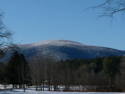
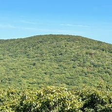
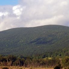
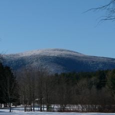
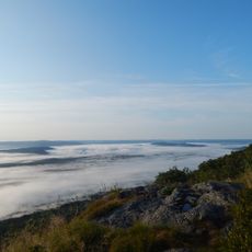
Mount Everett, Mountain summit in Southern Berkshires, Massachusetts, USA.

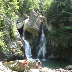
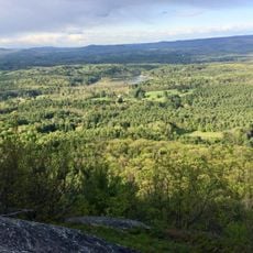
Mount Everett is the highest peak in the southern Taconic Mountains, rising about 2,600 feet (790 meters) above sea level. Multiple trails lead to the summit, with parking areas and camping spots available along the main routes.

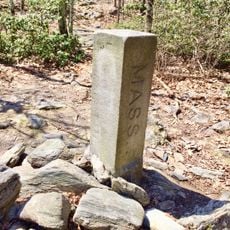
A geologist named Edward Hitchcock renamed the mountain in 1841 after Massachusetts governor Edward Everett. Before this change, it had gone by other names like Tacan Mountain, which were recorded by earlier observers.

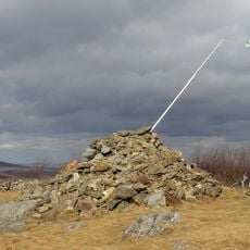
The Appalachian Trail runs across the summit and connects hikers to a wider network of paths through the Berkshires. This connection makes the peak an important meeting point for people exploring the region's natural spaces together.

The two main routes are Race Brook Trail and Elbow Trail, with camping spots available along the Race Brook route. Parking areas exist at the trailheads, and hikers should bring plenty of water and gear before heading up.

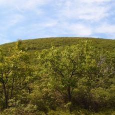
The summit hosts a rare dwarf forest of pitch pine and oak trees that thrive at this elevation. This compact forest creates a surprising woodland environment that many hikers do not expect to find at the peak.

The community of curious travelers

AroundUs brings together thousands of curated places, local tips, and hidden gems, enriched daily by 60,000 contributors worldwide.

Start exploring
Location
Elevation above the sea
793.1 m
GPS coordinates
42.10176,-73.43290
Latest update
December 10, 2025 16:00
Around this place
Bash Bish Falls
United States of America

Bash Bish Falls

5.2 km
Mount Frissell
United States of America

Mount Frissell

6.9 km
Bear Mountain
United States of America

Bear Mountain

6.6 km
Bash Bish Falls State Park
United States of America

Bash Bish Falls State Park

5.5 km
Bartholomew's Cobble
United States of America

Bartholomew's Cobble

8.4 km
W.E.B. Du Bois Boyhood Homesite
United States of America

W.E.B. Du Bois Boyhood Homesite

9.1 km
Brace Mountain
United States of America

Brace Mountain

8.1 km
Mount Washington State Forest
United States of America

Mount Washington State Forest

5.1 km
Colonel John Ashley House
United States of America

Colonel John Ashley House

7.9 km
Mount Everett State Reservation
United States of America

Mount Everett State Reservation

24 m
South Taconic Trail
United States of America

South Taconic Trail

8.1 km
Old Covered Bridge
United States of America

Old Covered Bridge

6.9 km
Jug End State Reservation and Wildlife Management Area
United States of America

Jug End State Reservation and Wildlife Management Area

5.3 km
Mount Riga State Park
United States of America

Mount Riga State Park

7.4 km
United States of America

Round Mountain

6.9 km
Copake Iron Works Historic District
United States of America

Copake Iron Works Historic District

7 km
Church of St. John in the Wilderness
United States of America

Church of St. John in the Wilderness

7.4 km
Benjamin Osborn House
United States of America

Benjamin Osborn House

3.5 km
Sheffield Plain Historic District
United States of America

Sheffield Plain Historic District

6.8 km
South Egremont Village Historic District
United States of America

South Egremont Village Historic District

6.5 km
Copake Memorial Clock
United States of America

Copake Memorial Clock

9.6 km
Sheffield Center Historic District
United States of America

Sheffield Center Historic District

6.7 km
North Chatham Historic District
United States of America

North Chatham Historic District

7 km
Columbia Turnpike-East Tollhouse
United States of America

Columbia Turnpike-East Tollhouse

10.4 km
Westover-Bacon-Potts Farm
United States of America

Westover-Bacon-Potts Farm

5.3 km
Wheeler Family Farmstead
United States of America

Wheeler Family Farmstead

10.3 km
General John and Mary Fellows Farmstead
United States of America

General John and Mary Fellows Farmstead

5.3 km
Mount Race
United States of America

Mount Race

2.2 km
Show the full map
« Mount Everett - Mountain summit in Southern Berkshires, Massachusetts, USA » is provided by Around Us (aroundus.com). Images and texts are derived from Wikimedia project under a Creative Commons license. You are allowed to copy, distribute, and modify copies of this page, under the conditions set by the license, as long as this note is clearly visible.

Discover hidden gems everywhere you go!

From secret cafés to breathtaking viewpoints, skip the crowded tourist spots and find places that match your style. Our app makes it easy with voice search, smart filtering, route optimization, and insider tips from travelers worldwide. Download now for the complete mobile experience.

Around Us App Screenshot

A unique approach to discovering new places

Le Figaro

All the places worth exploring

France Info

A tailor-made excursion in just a few clicks

20 Minutes

Around Us
Travel Guide & Maps
Download

Send to your phone

QR Code
1

Open the camera app on your mobile.

2

Point at the QR code with your camera. A notification will appear.

3

Tap the notification to open the link.