South Taconic Trail, Hiking trail in Dutchess County, United States.
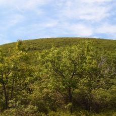
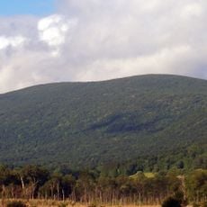
The South Taconic Trail is a 12-mile hiking route that winds through hardwood forests along the shared borders of New York, Massachusetts, and Connecticut, climbing to elevations above 2,300 feet. The path connects several mountain summits and passes through mixed terrain with rocky sections and forest cover.
The trail formed as part of the northeastern hiking network developed throughout the 20th century. Over time, it became established as a major route connecting multiple state borders and mountain summits.
White blazes marking the trail are maintained by local hiking groups who care for access to these mountain peaks. This voluntary work reflects how the hiking community values keeping these routes open and welcoming for outdoor visitors.
Access the trail from New York State Route 22 at White House Crossing Road in Ancram, where parking is available. Sturdy hiking boots are recommended for the rocky sections and steep climbs along the route.
The route leads to the highest point in Dutchess County at Brace Mountain, a rocky summit above 2,300 feet. Timber rattlesnakes inhabit the crevices and rocks near the peak, adding a wild element that hikers should be aware of during their visit.
The community of curious travelers
AroundUs brings together thousands of curated places, local tips, and hidden gems, enriched daily by 60,000 contributors worldwide.