Enable Location

We need your location to show you interesting places around you

Discover nearby places

Find interesting locations and hidden gems around you

Precise directions

Get accurate directions and distances to places

Your location is never shared with other users. It's only used when you tap the location button.

Pithole Stone Arch Bridge

Log in to your account

Start exploring — it's free

Trusted by 61,838 travelers worldwide

Continue with Google
Continue with Apple
or

We will send you a code to connect

By continuing, you accept our Terms and Conditions and our Privacy Policy

Check your inbox

We've sent a pincode in your inbox. Please enter the code below.

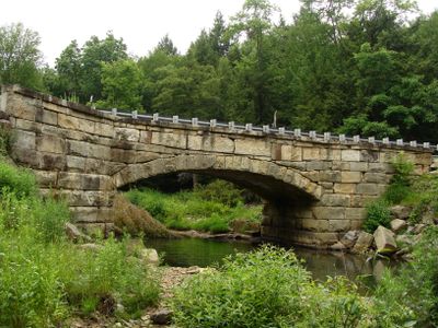
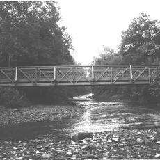
Pithole Stone Arch Bridge, Stone deck arch bridge in Cornplanter Township, Pennsylvania.

Description

Pithole Stone Arch Bridge is a stone arch crossing that spans Pithole Creek with a segmental arch design and coursed sandstone construction. The structure features substantial abutments and carries Eagle Rock Road between two townships.

History

Richard A. Bigley completed construction in 1899 after local residents submitted a petition for improved connections in 1897. The bridge was built during Pennsylvania's oil boom era.

Culture

The bridge connected communities during Pennsylvania's oil boom period, facilitating the movement of oil wagons and supporting regional economic development.

Practical

The bridge is accessible via Eagle Rock Road and allows both vehicle and pedestrian crossing over the creek. The location sits in a rural setting where you can approach and view the structure from either side.

Did you know?

The segmental arch design rises only 6 feet 7 inches, incorporating 628 square perches of locally sourced sandstone in its construction.

Made from material
stone
GPS coordinates
41.48690,-79.59530
Latest update
December 14, 2025 18:41

AroundUs brings together thousands of curated places, local tips, and hidden gems, enriched daily by 60,000 contributors worldwide. Discover all places nearby (Cornplanter Township).

Around this place
Drake Well
United States of America

Drake Well

14.7 km
Drake Well Museum
United States of America

Drake Well Museum

14.8 km
Oil Creek State Park
United States of America

Oil Creek State Park

7.6 km
Fort Machault
United States of America

Fort Machault

22 km
Indian God Rock
United States of America

Indian God Rock

25.9 km
United States of America

Fort Venango

21.8 km
Erie National Wildlife Refuge
United States of America

Erie National Wildlife Refuge

34.5 km
United States of America

Hickory Creek Wilderness

32.8 km
Rockland Furnace
United States of America

Rockland Furnace

30.9 km
Samuel F. Dale House
United States of America

Samuel F. Dale House

22.2 km
McClintocksville, Pennsylvania
United States of America

McClintocksville, Pennsylvania

4.3 km
Sutton-Ditz House
United States of America

Sutton-Ditz House

35 km
Clarion County Courthouse and Jail
United States of America

Clarion County Courthouse and Jail

34.9 km
Titusville City Hall
United States of America

Titusville City Hall

16.9 km
West Hickory Bridge
United States of America

West Hickory Bridge

18.3 km
Allegheny Baptist Church
United States of America

Allegheny Baptist Church

12.3 km
Jersey Bridge
United States of America

Jersey Bridge

15.2 km
Tidioute Bridge
United States of America

Tidioute Bridge

26.4 km
Bridge in Oil Creek Township
United States of America

Bridge in Oil Creek Township

18.2 km
Connely-Holeman House
United States of America

Connely-Holeman House

12 km
Titusville Historic District
United States of America

Titusville Historic District

17.2 km
Franklin Historic District
United States of America

Franklin Historic District

22.3 km
Witherup Bridge
United States of America

Witherup Bridge

33 km
Oil City Pennsylvania Railroad Bridge
United States of America

Oil City Pennsylvania Railroad Bridge

11.2 km
Barrow Civic Theater
United States of America

Barrow Civic Theater

21.9 km
Oil City Downtown Commercial Historic District
United States of America

Oil City Downtown Commercial Historic District

11 km
Oil City South Side Historic District
United States of America

Oil City South Side Historic District

12.7 km
Oil City North Side Historic District
United States of America

Oil City North Side Historic District

11.4 km
Show the full map
« Pithole Stone Arch Bridge - Stone deck arch bridge in Cornplanter Township, Pennsylvania » is provided by Around Us (aroundus.com). Images and texts are derived from Wikimedia project under a Creative Commons license. You are allowed to copy, distribute, and modify copies of this page, under the conditions set by the license, as long as this note is clearly visible.

Discover hidden gems everywhere you go!

From secret cafés to breathtaking viewpoints, skip the crowded tourist spots and find places that match your style. Our app makes it easy with voice search, smart filtering, route optimization, and insider tips from travelers worldwide. Download now for the complete mobile experience.

Around Us App Screenshot

A unique approach to discovering new places

Le Figaro

All the places worth exploring

France Info

A tailor-made excursion in just a few clicks

20 Minutes

Around Us
Travel Guide & Maps
Download

Send to your phone

QR Code
1

Open the camera app on your mobile.

2

Point at the QR code with your camera. A notification will appear.

3

Tap the notification to open the link.