Union Pacific Missouri River Bridge

Log in to your account

AroundUs is a community-driven map of interesting places, built by curious explorers like you. It grows with every review, story, and photo you share.
Connect to save your favorite spots, contribute locations, and create personalized routes.
Continue with Google
Continue with Apple
Continue with X
Continue with Facebook
Continue with email
By continuing, you accept our Terms and Conditions and our Privacy Policy
Create an account

Union Pacific Missouri River Bridge

Add to collection
Map
Suggest a change
Share

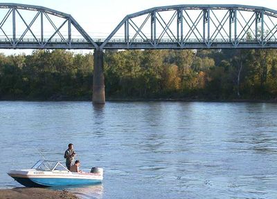
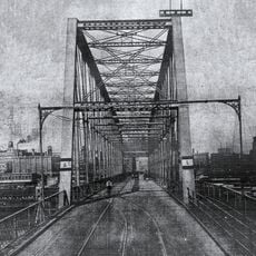
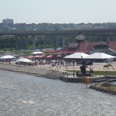
Union Pacific Missouri River Bridge, Railway bridge in Council Bluffs, United States.

The Union Pacific Missouri River Bridge is a railway bridge made of steel trusses that spans 533 meters across the Missouri River, connecting Council Bluffs, Iowa with Omaha, Nebraska. The structure rests on deep foundations anchored in the riverbed, with a robust framework of support columns throughout its length.

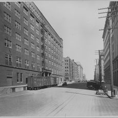
The current structure was completed in 1916 and is the third bridge at this location, as earlier versions from 1872 and 1885 could no longer meet the growing demands of railroad traffic. The evolution of these bridges shows how quickly transportation needs changed across several decades.

The bridge serves as a key part of America's railway network and shows how technology and industry shaped transportation connections between East and West. For visitors today, it stands as a visible reminder of how engineering transformed commerce across the continent.

From the Iowa side, the bridge is easily accessible near Harrah's Casino, and it operates continuously for train traffic. It is best to view this bridge from a safe distance to avoid interfering with active rail operations.

During construction, engineers used compressed air techniques to drive steel columns deep into the riverbed, creating stable foundations without interrupting train service. This method was a remarkable engineering achievement for its time.

Location: Iowa

Location: Nebraska

Official opening: 1916

Length: 533 m

GPS coordinates: 41.24970,-95.91720

Latest update: December 9, 2025 18:42

Photos
Around this place
Jobbers Canyon Historic District
United States of America

Jobbers Canyon Historic District

1.1 km
Lauritzen Gardens
United States of America

Lauritzen Gardens

1.4 km
Durham Museum
United States of America

Durham Museum

956 m
Heartland of America Park
United States of America

Heartland of America Park

1.1 km
Harrah's Council Bluffs
United States of America

Harrah's Council Bluffs

308 m
Holland Performing Arts Center
United States of America

Holland Performing Arts Center

1.7 km
Ak-Sar-Ben Bridge
United States of America

Ak-Sar-Ben Bridge

1.2 km
Joel N. Cornish House
United States of America

Joel N. Cornish House

1.2 km
St. Frances Cabrini Catholic Church
United States of America

St. Frances Cabrini Catholic Church

1.1 km
Lewis and Clark Landing
United States of America

Lewis and Clark Landing

1.5 km
Omaha Rail and Commerce Historic District
United States of America

Omaha Rail and Commerce Historic District

1.1 km
Prague Hotel
United States of America

Prague Hotel

1.6 km
Christian Specht Building
United States of America

Christian Specht Building

1.5 km
Burlington Headquarters Building
United States of America

Burlington Headquarters Building

1.3 km
Elsasser Bakery
United States of America

Elsasser Bakery

1.6 km
Bemis Omaha Bag Company Building
United States of America

Bemis Omaha Bag Company Building

1.2 km
Anheuser-Busch Beer Depot
United States of America

Anheuser-Busch Beer Depot

676 m
Swoboda Bakery
United States of America

Swoboda Bakery

1.6 km
Hospe Music Warehouse
United States of America

Hospe Music Warehouse

1.4 km
Holland Center For Performing Arts
United States of America

Holland Center For Performing Arts

1.7 km
1200 Landmark Center
United States of America

1200 Landmark Center

1.5 km
Bishop Worthington Residence
United States of America

Bishop Worthington Residence

1.1 km
Kirschbraun and Sons Creamery, Inc.
United States of America

Kirschbraun and Sons Creamery, Inc.

1.4 km
Center School
United States of America

Center School

1.4 km
Eggerss–O'Flyng Building
United States of America

Eggerss–O'Flyng Building

1.5 km
Museum Of Shadows
United States of America

Museum Of Shadows

1.5 km
Old City Hall
United States of America

Old City Hall

1.3 km
Kiewit Luminarium
United States of America

Kiewit Luminarium

1.5 km
Show the full map
Reviews

Visited this place? Tap the stars to rate it and share your experience / photos with the community! Try now! You can cancel it anytime.

« Union Pacific Missouri River Bridge - Railway bridge in Council Bluffs, United States » is provided by Around Us (aroundus.com). Images and texts are derived from Wikimedia project under a Creative Commons license. You are allowed to copy, distribute, and modify copies of this page, under the conditions set by the license, as long as this note is clearly visible.

Discover hidden gems everywhere you go!

From secret cafés to breathtaking viewpoints, skip the crowded tourist spots and find places that match your style. Our app makes it easy with voice search, smart filtering, route optimization, and insider tips from travelers worldwide. Download now for the complete mobile experience.

Around Us App Screenshot

A unique approach to discovering new places

Le Figaro

All the places worth exploring

France Info

A tailor-made excursion in just a few clicks

20 Minutes