Enable Location

We need your location to show you interesting places around you

Discover nearby places

Find interesting locations and hidden gems around you

Precise directions

Get accurate directions and distances to places

Your location is never shared with other users. It's only used when you tap the location button.

Ak-Sar-Ben Bridge

Log in to your account

Start exploring — it's free

Trusted by 63,013 travelers worldwide

Continue with Google
Continue with Apple
or

We will send you a code to connect

By continuing, you accept our Terms and Conditions and our Privacy Policy

Check your inbox

We've sent a pincode in your inbox. Please enter the code below.

Ak-Sar-Ben Bridge
Discussion Reviews 1 Photos
3.7k Popularity

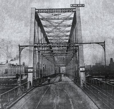
Ak-Sar-Ben Bridge, Road bridge between Omaha and Council Bluffs, United States

The Ak-Sar-Ben Bridge is a road bridge that spans the Missouri River between Omaha in Nebraska and Council Bluffs in Iowa. It features a Whipple through truss design that carries traffic across the river connecting these two communities.

The structure was built in 1888 and was the first road bridge to cross the Missouri River between Omaha and Council Bluffs. It operated as a toll bridge until 1947, when it became free for all vehicles to use.

The bridge took its name from the Knights of Ak-Sar-Ben, an organization founded in 1895 that spelled Nebraska backwards to create their identity. This name remains rooted in local memory and reflects how the community shaped its own symbols and stories.

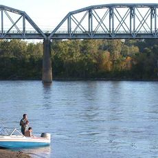
Visitors should know that the original bridge was demolished in 1968 and is no longer passable by vehicle. However, one pier from the original structure remains in the river and can be seen from various viewpoints along the shoreline.

Even though the bridge was completely demolished in 1968, the east pier still stands in the river as a reminder of the original 1888 construction. This solitary pier is a quiet testament to 19th-century engineering and shows that not everything from the past structure was erased.

The community of curious travelers

AroundUs brings together thousands of curated places, local tips, and hidden gems, enriched daily by 60,000 contributors worldwide.

Start exploring
Location
Location
Official opening
1888
GPS coordinates
41.25980,-95.92100
Latest update
December 11, 2025 18:09
Around this place
CHI Health Center Omaha
United States of America

CHI Health Center Omaha

682 m
Bob Kerrey Pedestrian Bridge
United States of America

Bob Kerrey Pedestrian Bridge

658 m
Jobbers Canyon Historic District
United States of America

Jobbers Canyon Historic District

684 m
Durham Museum
United States of America

Durham Museum

1.1 km
Heartland of America Park
United States of America

Heartland of America Park

502 m
Harrah's Council Bluffs
United States of America

Harrah's Council Bluffs

1.1 km
Union Pacific Missouri River Bridge
United States of America

Union Pacific Missouri River Bridge

1.2 km
Union Pacific Center
United States of America

Union Pacific Center

1.2 km
Orpheum Theater
United States of America

Orpheum Theater

1.3 km
Holland Performing Arts Center
United States of America

Holland Performing Arts Center

956 m
Slowdown
United States of America

Slowdown

1.3 km
Film Streams
United States of America

Film Streams

1.3 km
Lewis and Clark Landing
United States of America

Lewis and Clark Landing

378 m
United States of America

Union Pacific Railroad Omaha Shops Facility

709 m
Omaha Rail and Commerce Historic District
United States of America

Omaha Rail and Commerce Historic District

1.1 km
Christian Specht Building
United States of America

Christian Specht Building

849 m
Central Park Plaza
United States of America

Central Park Plaza

1.3 km
RiverFront Place Condos
United States of America

RiverFront Place Condos

849 m
Holland Center For Performing Arts
United States of America

Holland Center For Performing Arts

955 m
1200 Landmark Center
United States of America

1200 Landmark Center

950 m
Grand Central Hotel
United States of America

Grand Central Hotel

1.2 km
Kirschbraun and Sons Creamery, Inc.
United States of America

Kirschbraun and Sons Creamery, Inc.

597 m
Rose Realty-Securities Building
United States of America

Rose Realty-Securities Building

1.3 km
Museum Of Shadows
United States of America

Museum Of Shadows

851 m
Pioneer Courage Park
United States of America

Pioneer Courage Park

1.2 km
Old City Hall
United States of America

Old City Hall

552 m
Kiewit Luminarium
United States of America

Kiewit Luminarium

368 m
River City Star
United States of America

River City Star

1.3 km
Show the full map
Reviews
Share your experience

No review yet

Discussions
Start a discussion...

No discussion yet

« Ak-Sar-Ben Bridge - Road bridge between Omaha and Council Bluffs, United States » is provided by Around Us (aroundus.com). Images and texts are derived from Wikimedia project under a Creative Commons license. You are allowed to copy, distribute, and modify copies of this page, under the conditions set by the license, as long as this note is clearly visible.

Discover hidden gems everywhere you go!

From secret cafés to breathtaking viewpoints, skip the crowded tourist spots and find places that match your style. Our app makes it easy with voice search, smart filtering, route optimization, and insider tips from travelers worldwide. Download now for the complete mobile experience.

Around Us App Screenshot

A unique approach to discovering new places

Le Figaro

All the places worth exploring

France Info

A tailor-made excursion in just a few clicks

20 Minutes

Around Us
Travel Guide & Maps
Download

Send to your phone

QR Code
1

Open the camera app on your mobile.

2

Point at the QR code with your camera. A notification will appear.

3

Tap the notification to open the link.