Enable Location

We need your location to show you interesting places around you

Discover nearby places

Find interesting locations and hidden gems around you

Precise directions

Get accurate directions and distances to places

Your location is never shared with other users. It's only used when you tap the location button.

Log in to your account

Start exploring — it's free

Trusted by 62,469 travelers worldwide

Continue with Google
Continue with Apple
or

We will send you a code to connect

By continuing, you accept our Terms and Conditions and our Privacy Policy

Check your inbox

We've sent a pincode in your inbox. Please enter the code below.

State Game Lands Number 189

State Game Lands Number 189, Protected wildlife area in Beaver County, United States.

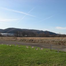
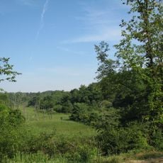
State Game Lands Number 189 is a protected wildlife area spanning about 170 hectares across Hanover and Independence Townships in Beaver County. The land features rolling terrain with forests and open spaces where visitors can observe wildlife in its natural setting.

The Pennsylvania Game Commission established this area as a protected wildlife zone during the 1970s as part of a broader conservation strategy. It remains part of the state's network of game lands dedicated to wildlife management and public outdoor use.

Pennsylvania residents maintain strong connections to outdoor traditions through designated hunting seasons and wildlife observation activities within these preserved natural spaces.

The main entrance is accessible from U.S. Route 30 on the southwest side, where parking is available. Visitors should respect current hunting seasons and come prepared for variable weather and forested terrain.

This protected area consists of two separate land parcels, with the smaller section positioned near Raccoon Creek State Park to form part of a larger wildlife corridor. This arrangement helps connect natural habitats across a wider region.

The community of curious travelers

AroundUs brings together thousands of curated places, local tips, and hidden gems, enriched daily by 60,000 contributors worldwide.

Start exploring
Location
Location
GPS coordinates
40.52833,-80.36111
Latest update
December 14, 2025 16:44
Around this place
Raccoon Creek State Park
United States of America

Raccoon Creek State Park

7.2 km
Old Economy Village
United States of America

Old Economy Village

13.2 km
Legionville
United States of America

Legionville

15.3 km
Hillman State Park
United States of America

Hillman State Park

10.6 km
Sewickley Bridge
United States of America

Sewickley Bridge

14.7 km
Wilpen Hall
United States of America

Wilpen Hall

17.9 km
Coraopolis Bridge
United States of America

Coraopolis Bridge

17.8 km
Montgomery Locks and Dam
United States of America

Montgomery Locks and Dam

13.7 km
Dashields Locks and Dam
United States of America

Dashields Locks and Dam

13.5 km
Ambridge-Aliquippa Bridge
United States of America

Ambridge-Aliquippa Bridge

12.7 km
Devil's Den, McClurg Covered Bridge
United States of America

Devil's Den, McClurg Covered Bridge

16.9 km
B.F. Jones Memorial Library
United States of America

B.F. Jones Memorial Library

13.2 km
Elmridge
United States of America

Elmridge

13.8 km
Shippingport Bridge
United States of America

Shippingport Bridge

12.5 km
Merrill Lock No. 6
United States of America

Merrill Lock No. 6

15.6 km
Vanport Bridge
United States of America

Vanport Bridge

17 km
Sewickley Public Library
United States of America

Sewickley Public Library

15.2 km
Nicholas Way House
United States of America

Nicholas Way House

14.8 km
Coraopolis Armory
United States of America

Coraopolis Armory

16.3 km
Mooncrest Historic District
United States of America

Mooncrest Historic District

14.5 km
David Littell House
United States of America

David Littell House

4.8 km
Lyle Covered Bridge
United States of America

Lyle Covered Bridge

8.3 km
Ralston Freeman Covered Bridge
United States of America

Ralston Freeman Covered Bridge

15.3 km
899 Old Thorn Run Road
United States of America

899 Old Thorn Run Road

14 km
Jackson's Mill Covered Bridge
United States of America

Jackson's Mill Covered Bridge

15.9 km
David Shields House
United States of America

David Shields House

14 km
United States Post Office-Sewickley Branch
United States of America

United States Post Office-Sewickley Branch

15 km
Joe Walton Stadium
United States of America

Joe Walton Stadium

12.3 km
Show the full map
« State Game Lands Number 189 - Protected wildlife area in Beaver County, United States » is provided by Around Us (aroundus.com). Images and texts are derived from Wikimedia project under a Creative Commons license. You are allowed to copy, distribute, and modify copies of this page, under the conditions set by the license, as long as this note is clearly visible.

Discover hidden gems everywhere you go!

From secret cafés to breathtaking viewpoints, skip the crowded tourist spots and find places that match your style. Our app makes it easy with voice search, smart filtering, route optimization, and insider tips from travelers worldwide. Download now for the complete mobile experience.

Around Us App Screenshot

A unique approach to discovering new places

Le Figaro

All the places worth exploring

France Info

A tailor-made excursion in just a few clicks

20 Minutes

Around Us
Travel Guide & Maps
Download

Send to your phone

QR Code
1

Open the camera app on your mobile.

2

Point at the QR code with your camera. A notification will appear.

3

Tap the notification to open the link.