Enable Location

We need your location to show you interesting places around you

Discover nearby places

Find interesting locations and hidden gems around you

Precise directions

Get accurate directions and distances to places

Your location is never shared with other users. It's only used when you tap the location button.

Neshanic Station Lenticular Truss Bridge

Log in to your account

Start exploring — it's free

Trusted by 62,367 travelers worldwide

Continue with Google
Continue with Apple
or

We will send you a code to connect

By continuing, you accept our Terms and Conditions and our Privacy Policy

Check your inbox

We've sent a pincode in your inbox. Please enter the code below.

Neshanic Station Lenticular Truss Bridge

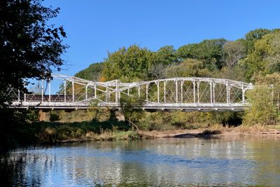
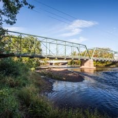
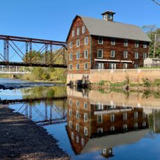
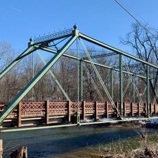
Neshanic Station Lenticular Truss Bridge, Iron truss bridge at Neshanic Station, United States.

The Neshanic Station Lenticular Truss Bridge is a road bridge crossing the South Branch Raritan River in Somerset County. It carries traffic along State Route 567 and features two equal steel spans with curved upper chords.

The bridge was built in 1896 by the Berlin Iron Bridge Company during an era when New Jersey was expanding its transportation network. It reflects the engineering solutions developed in that period to improve regional connectivity.

The bridge represents the technical expertise of 19th century American civil engineering, reflecting the industrial advancement of the northeastern United States.

The bridge is easily reached via State Route 567 and remains open for regular vehicle traffic. You can view it from the road or adjacent areas where parking may be available for inspection.

This is the only remaining lenticular truss bridge left in New Jersey, making it a rare surviving example of this design type. The curved upper chords create an unusual silhouette that was engineered to handle weight more efficiently.

The community of curious travelers

AroundUs brings together thousands of curated places, local tips, and hidden gems, enriched daily by 60,000 contributors worldwide.

Start exploring
Location
Inception
1896
Architects
Berlin Iron Bridge Co.
Part of
Neshanic Mills, Neshanic Station Historic District
GPS coordinates
40.50944,-74.72694
Latest update
December 14, 2025 16:41
Around this place
Duke Farms
United States of America

Duke Farms

10.6 km
Highfields
United States of America

Highfields

10.1 km
Duke Gardens
United States of America

Duke Gardens

10.2 km
Northlandz
United States of America

Northlandz

7.9 km
Sourland Mountain
United States of America

Sourland Mountain

4.8 km
Sourland Mountain Preserve
United States of America

Sourland Mountain Preserve

4.7 km
Nevius Street Bridge
United States of America

Nevius Street Bridge

9.9 km
General John Frelinghuysen House
United States of America

General John Frelinghuysen House

10.5 km
Neshanic Mills
United States of America

Neshanic Mills

132 m
John Basilone Veterans Memorial Bridge
United States of America

John Basilone Veterans Memorial Bridge

9.8 km
Rockafellows Mill Bridge
United States of America

Rockafellows Mill Bridge

8 km
Andrew Ten Eyck House
United States of America

Andrew Ten Eyck House

6 km
Dart's Mill Historic District
United States of America

Dart's Mill Historic District

9.6 km
Dirck Gulick House
United States of America

Dirck Gulick House

7.5 km
Mount Zion African Methodist Episcopal Church
United States of America

Mount Zion African Methodist Episcopal Church

10.3 km
Huff House and Farmstead
United States of America

Huff House and Farmstead

944 m
John Reading Farmstead
United States of America

John Reading Farmstead

9.5 km
Raritan-Readington South Branch Historic District
United States of America

Raritan-Readington South Branch Historic District

9.7 km
South Branch Schoolhouse
United States of America

South Branch Schoolhouse

4.9 km
South Branch Reformed Church
United States of America

South Branch Reformed Church

4.8 km
Readington Village Historic District
United States of America

Readington Village Historic District

6.6 km
Neshanic Reformed Church
United States of America

Neshanic Reformed Church

1.4 km
Clover Hill Reformed Church
United States of America

Clover Hill Reformed Church

5.2 km
Reaville Historic District
United States of America

Reaville Historic District

8.8 km
Clover Hill Historic District
United States of America

Clover Hill Historic District

5.4 km
Neshanic Historic District
United States of America

Neshanic Historic District

1.4 km
Neshanic Station Historic District
United States of America

Neshanic Station Historic District

410 m
South Branch Historic District
United States of America

South Branch Historic District

4.8 km
Show the full map
« Neshanic Station Lenticular Truss Bridge - Iron truss bridge at Neshanic Station, United States » is provided by Around Us (aroundus.com). Images and texts are derived from Wikimedia project under a Creative Commons license. You are allowed to copy, distribute, and modify copies of this page, under the conditions set by the license, as long as this note is clearly visible.

Discover hidden gems everywhere you go!

From secret cafés to breathtaking viewpoints, skip the crowded tourist spots and find places that match your style. Our app makes it easy with voice search, smart filtering, route optimization, and insider tips from travelers worldwide. Download now for the complete mobile experience.

Around Us App Screenshot

A unique approach to discovering new places

Le Figaro

All the places worth exploring

France Info

A tailor-made excursion in just a few clicks

20 Minutes

Around Us
Travel Guide & Maps
Download

Send to your phone

QR Code
1

Open the camera app on your mobile.

2

Point at the QR code with your camera. A notification will appear.

3

Tap the notification to open the link.