Enable Location

We need your location to show you interesting places around you

Discover nearby places

Find interesting locations and hidden gems around you

Precise directions

Get accurate directions and distances to places

Your location is never shared with other users. It's only used when you tap the location button.

Neshanic Mills

Log in to your account

Start exploring — it's free

Trusted by 63,069 travelers worldwide

Continue with Google
Continue with Apple
or

We will send you a code to connect

By continuing, you accept our Terms and Conditions and our Privacy Policy

Check your inbox

We've sent a pincode in your inbox. Please enter the code below.

Discussion Reviews 1 Photos
1.6k Popularity

Neshanic Mills, Historic district in Neshanic Station, United States

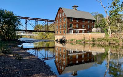
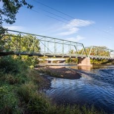
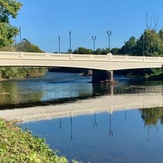
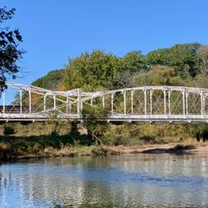
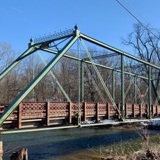
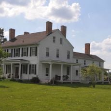
Neshanic Mills is a historic district containing four buildings and two structures spread across the landscape where the South Branch Raritan River flows through. The central element is a three-story grist mill built of stone and brick, surrounded by associated structures including a distinctive iron truss bridge.

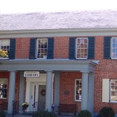
Andrew Lane built the grist mill in 1876 and kept it operating for more than 70 years as an active industrial facility. After its closure in the late 1940s, the building was converted for residential use but remains a documented historic landmark.

The milling operation served as the economic heart of the local community for generations, drawing workers and creating a small industrial village. You can sense this legacy today as you walk among the old structures standing near the water.

The site is located where River Road meets Mill Lane, making it straightforward to find and walk around the grounds. Sturdy footwear is advisable since the terrain is uneven and pathways near the water can be steep in places.

An iron truss bridge built in 1896 by the Berlin Iron Bridge Company still stands at the site and displays the craftsmanship of the late 1800s. This bridge was designed to cross over railroad tracks of the Central Railroad of New Jersey, showing how the mill connected to broader transportation networks.

The community of curious travelers

AroundUs brings together thousands of curated places, local tips, and hidden gems, enriched daily by 60,000 contributors worldwide.

Start exploring
Location
GPS coordinates
40.50861,-74.72583
Latest update
December 14, 2025 14:25
Around this place
Duke Farms
United States of America

Duke Farms

10.6 km
Highfields
United States of America

Highfields

10.1 km
Duke Gardens
United States of America

Duke Gardens

10.2 km
Northlandz
United States of America

Northlandz

8 km
Sourland Mountain
United States of America

Sourland Mountain

4.7 km
Sourland Mountain Preserve
United States of America

Sourland Mountain Preserve

4.6 km
Nevius Street Bridge
United States of America

Nevius Street Bridge

9.8 km
General John Frelinghuysen House
United States of America

General John Frelinghuysen House

10.5 km
John Basilone Veterans Memorial Bridge
United States of America

John Basilone Veterans Memorial Bridge

9.8 km
Neshanic Station Lenticular Truss Bridge
United States of America

Neshanic Station Lenticular Truss Bridge

132 m
Rockafellows Mill Bridge
United States of America

Rockafellows Mill Bridge

8.1 km
Andrew Ten Eyck House
United States of America

Andrew Ten Eyck House

6.1 km
Dart's Mill Historic District
United States of America

Dart's Mill Historic District

9.7 km
Dirck Gulick House
United States of America

Dirck Gulick House

7.4 km
Mount Zion African Methodist Episcopal Church
United States of America

Mount Zion African Methodist Episcopal Church

10.2 km
Huff House and Farmstead
United States of America

Huff House and Farmstead

999 m
John Reading Farmstead
United States of America

John Reading Farmstead

9.6 km
Raritan-Readington South Branch Historic District
United States of America

Raritan-Readington South Branch Historic District

9.8 km
South Branch Schoolhouse
United States of America

South Branch Schoolhouse

4.9 km
South Branch Reformed Church
United States of America

South Branch Reformed Church

4.9 km
Readington Village Historic District
United States of America

Readington Village Historic District

6.7 km
Neshanic Reformed Church
United States of America

Neshanic Reformed Church

1.3 km
Clover Hill Reformed Church
United States of America

Clover Hill Reformed Church

5.3 km
Reaville Historic District
United States of America

Reaville Historic District

8.8 km
Clover Hill Historic District
United States of America

Clover Hill Historic District

5.4 km
Neshanic Historic District
United States of America

Neshanic Historic District

1.2 km
Neshanic Station Historic District
United States of America

Neshanic Station Historic District

494 m
South Branch Historic District
United States of America

South Branch Historic District

4.8 km
Show the full map
Reviews
Share your experience

No review yet

Discussions
Start a discussion...

No discussion yet

« Neshanic Mills - Historic district in Neshanic Station, United States » is provided by Around Us (aroundus.com). Images and texts are derived from Wikimedia project under a Creative Commons license. You are allowed to copy, distribute, and modify copies of this page, under the conditions set by the license, as long as this note is clearly visible.

Discover hidden gems everywhere you go!

From secret cafés to breathtaking viewpoints, skip the crowded tourist spots and find places that match your style. Our app makes it easy with voice search, smart filtering, route optimization, and insider tips from travelers worldwide. Download now for the complete mobile experience.

Around Us App Screenshot

A unique approach to discovering new places

Le Figaro

All the places worth exploring

France Info

A tailor-made excursion in just a few clicks

20 Minutes

Around Us
Travel Guide & Maps
Download

Send to your phone

QR Code
1

Open the camera app on your mobile.

2

Point at the QR code with your camera. A notification will appear.

3

Tap the notification to open the link.