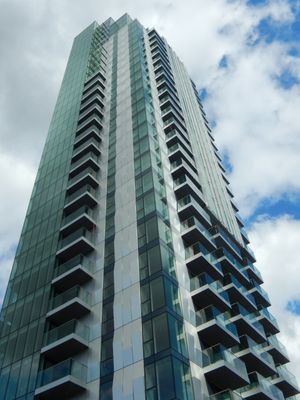
Skyline, Modern residential building in Woodberry Down, London, United Kingdom.
Skyline is a contemporary residential building in Woodberry Down featuring clean architectural lines, large windows that flood interiors with light, and a tall profile that stands out in the neighborhood. The structure contains multiple housing units arranged around shared courtyards and includes ground-floor commercial spaces that face the street.
The building was constructed during Woodberry Down's major regeneration phase, replacing post-war housing that had served the area for decades. This development represents a shift toward higher-density, contemporary residential solutions in this part of northeast London.
Residents of Skyline participate in local community events and activities, reflecting the diversity and social character of the Hackney borough.
The building sits directly on accessible streets with nearby public transportation options making it easy to reach by bus or walking. Since it is a residential property, visitors can view it from public areas, though access to interior courtyards and lobbies may be restricted.
The roofline includes a rainwater harvesting system that collects precipitation for use in landscape irrigation across the site. This hidden feature reflects how the designers integrated practical environmental thinking into the building's everyday operations.
Location: London Borough of Hackney
GPS coordinates: 51.57174,-0.08954
Latest update: December 14, 2025 13:01
Finsbury Park
788 m
Abney Park Cemetery
1.1 km
Clissold Park
1.2 km
Woodberry Wetlands
219 m
Abney Park Chapel
1.2 km
Railway Fields
990 m
Old Church of St Mary
1.2 km
Stoke Newington Municipal Buildings And Surrounding Walls
1.2 km
Church of St Andrew, Hackney
654 m
St Ann's Church
1.1 km
Clissold Park
1.2 km
Fowler Newsam Hall
1.1 km
Monument To Frank Bostock In Abney Park Cemetery
1.2 km
Monument To William Tyler In Abney Park Cemetery
1.2 km
Church of St Olave
290 m
St Ann's Church School
1.2 km
Spreat Monument In Abney Park Cemetery
1.2 km
Engine House Of Metropolitan Water Board
744 m
Pair Of K2 Telephone Kiosks Outside Number 117
1.2 km
Ancillary Building To North Of Engine House Of Metropolitan Water Board
716 m
Gas House To West Of Reservoir
232 m
Walls And Railings To Former Metropolitan Water Board Pumping Station; West Side Of Green Lanes From K2 Kiosk North For 15 Bays; East Side Of Green Lanes From Boundary With 212 Green Lanes North For 13 Bays
788 m
Tomb Of Anna Laetitia Barbauld, Churchyard Of Old Church Of St Mary
1.2 km
Tomb Of James Stephen, Churchyard Of Old Church Of St Mary
1.2 km
Post Office Pillar Box At East Corner Of King's Crescent
1.2 km
Ivy House Sluice
361 m
K2 Telephone Kiosk Outside Number 281, Green Lanes
857 m
8, Lordship Road N16
1.2 kmVisited this place? Tap the stars to rate it and share your experience / photos with the community! Try now! You can cancel it anytime.
Discover hidden gems everywhere you go!
From secret cafés to breathtaking viewpoints, skip the crowded tourist spots and find places that match your style. Our app makes it easy with voice search, smart filtering, route optimization, and insider tips from travelers worldwide. Download now for the complete mobile experience.
A unique approach to discovering new places❞
— Le Figaro
All the places worth exploring❞
— France Info
A tailor-made excursion in just a few clicks❞
— 20 Minutes