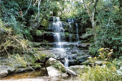
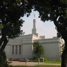
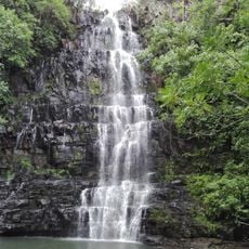
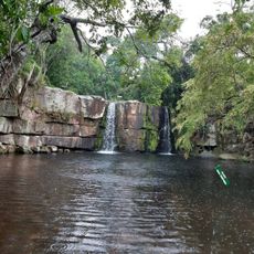
Salto Guaraní, Waterfall in Paraguarí, Paraguay.
A waterfall in Paraguarí province cascades over multiple tiers of black basalt rock formations, surrounded by subtropical vegetation. The water descends through several levels, forming successive natural pools between the rock ledges. Dense tree cover frames the cascade, while ferns and mosses grow on the moist rock surfaces. The volume of water varies according to the season and affects the flow rate across the formations.
During the pre-colonial era, various indigenous groups used the waterfall area as a geographic reference point for their territories. European cartographers first documented the site in the eighteenth century during the Spanish colonial period. In the twentieth century, the area was developed for local access, and basic paths were created leading to the rock formations. Conservation measures began in the nineteen nineties to protect the surrounding forest areas.
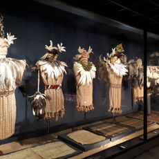
Local families use this site as a gathering point for community events. The Guaraní people consider the flowing water a spiritual element of their landscape and incorporate the location into their oral traditions. During the rainy season, residents from surrounding villages assemble to celebrate communal festivals and prepare traditional foods. The waterfall plays an important role in the cultural memory of the region.
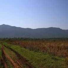
Visitors reach the cascade via a marked trail from the main parking area, approximately 800 meters away. Wooden viewing platforms at different elevations provide vantage points for observing the falls. The best time to visit is from April through October when humidity levels are lower. Sturdy footwear is recommended for the trail. Local vendors offer refreshments near the entrance on weekends. No formal facilities exist at the site itself.
The varying mineral deposits in the basalt rock create color shifts in the water ranging from greenish to brownish, depending on rainfall patterns and sediment concentrations. Geologists have identified unusual hexagonal column structures in the basalt formed during volcanic cooling processes. The natural pools contain microscopic organisms not documented elsewhere in Paraguay. Some rock formations display pre-Columbian markings of unknown origin.
Location: Paraguarí
Address: W5J2+M34, Mbokaja Puku 091607, Paraguay 091607 Mbokaja Puku
GPS coordinates: -26.06747,-56.84892
Latest update: November 27, 2025 21:12
Paraguay features a combination of natural sites, historical structures, and cultural institutions. In the capital Asunción, central buildings include the López Palace, the National Museum, and the National Pantheon of Heroes. The waterfront promenade runs along the river. The city contains several museums, including the Barro Museum with folk art and the Independence House. Religious structures include the Cathedral of Our Lady of the Assumption. The Botanical Garden includes a zoo. The Itapúa region contains two Jesuit reductions: Santísima Trinidad de Paraná and Jesús de Tavarangüé, both from the 17th and 18th centuries. In Ciudad del Este, the second largest city, modern shopping centers include Nissei and Monalisa, along with the Itaipú hydroelectric dam on the Brazilian border. The Monday Falls are located nearby. The Friendship Bridge connects Paraguay to Brazil. Natural areas include Lake Ypacaraí, a 90 square kilometer lake (35 square miles) near Asunción, and Ybycuí National Park with hiking trails and waterfalls. San Bernardino on the shores of Lake Ypacaraí has a viewpoint and a church. The Siete Saltos waterfalls are in the northern Salto del Guairá region.
Vapor Cué National Park
94 km
Ñu Guasú
113.1 km
Icono Tower
116.4 km
Cerro Lambaré
113.4 km
Mburuvicha Róga
114.6 km
St. Lawrence Cathedral, San Lorenzo
104.4 km
World Trade Center Asuncion
113.1 km
Cerro Ñemby
100.9 km
Museo Nacional de Bellas Artes de Asunción
116.3 km
Colegio Internacional
115.8 km
Asunción Paraguay Temple
115.1 km
Estadio General Adrián Jara
111.9 km
Salto Cristal
16 km
Los Pynandi World Cup Stadium
113.3 km
Mirador Bella Vista
96.1 km
Museum of the Conmebol
111.9 km
Ypoá National Park
60.6 km
Estadio José Tomás Silva
115.5 km
Estadio del Bicentenario Nacional
85 km
Museo del Barro
112.8 km
Estadio Presbítero Manuel Gamarra
81.2 km
Ybycuí National Park
3.5 km
Reserva de recursos manejados Yvytyrusú
66.9 km
Our Lady of the Assumption
96.1 km
Church of San Lorenzo
98.4 km
Museo judio del paraguay
116 km
Castillo Carlota Palmerola
100.3 km
Cathedral of Our Lady of the Rosary, Coronel Oviedo
80.4 kmReviews
Visited this place? Tap the stars to rate it and share your experience / photos with the community! Try now! You can cancel it anytime.
Discover hidden gems everywhere you go!
From secret cafés to breathtaking viewpoints, skip the crowded tourist spots and find places that match your style. Our app makes it easy with voice search, smart filtering, route optimization, and insider tips from travelers worldwide. Download now for the complete mobile experience.
A unique approach to discovering new places❞
— Le Figaro
All the places worth exploring❞
— France Info
A tailor-made excursion in just a few clicks❞
— 20 Minutes