Chest opened
+${chestReward.xp} XP
Explorer
NOUVEAU ×${chestReward.collectible.quantity}
tapez pour fermer

See the monuments around you in AR Open chests in the app

Around Us is built for your phone — point your camera at the streets and discover the monuments and places around you in augmented reality. Around Us is built for your phone — chests unlock when you walk, explore and capture nearby places.

•

Enable Location

We need your location to show you interesting places around you

Discover nearby places

Find interesting locations and hidden gems around you

Precise directions

Get accurate directions and distances to places

Your location is never shared with other users. It's only used when you tap the location button.

Cerro Ñemby

Log in to your account

Start exploring — it's free

Trusted by 93,009 travelers worldwide

Continue with Google
Continue with Apple
or

We will send you a code to connect

By continuing, you accept our Terms and Conditions and our Privacy Policy

Check your inbox

We've sent a pincode in your inbox. Please enter the code below.

Cerro Ñemby

Cerro Ñemby, Volcanic hill in Ñemby, Paraguay.

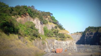
Cerro Ñemby is a volcanic hill in the Caaguazú neighbourhood of Ñemby, about 1,450 metres from the city centre. It has the form of a truncated cone with a base diameter of nearly 700 metres. Its solidified basaltic lava, about 45 million years old, was quarried for paving material, and the west side now stands at 154 metres while the east side reaches 206 metres.

The first written references to the hill date from the 18th century, when it was called cerro de La Frontera or Ñemby. Félix de Azara noted it on 8 February 1784, and on 2 September 1784 the pilot Pablo Zizur marked the "cerrito de La Frontera o Ñemby". Aguirre passed through in 1794 and recorded the same name. Old maps also label it Reducto (Mouchez, 1861) and Caaguazú (Gásperi, around 1920).

The name Ñemby may come from a Cario chief who held authority in the area when the conquistadors arrived, or from a Guaraní phrase meaning "stone that came out from inside", referring to the hill's volcanic origin. In old maps it also appears as Reducto, linked to the Jesuits of San Lorenzo, and as Caaguazú, from the Guaraní for "high forest".

The hill lies in the Caaguazú neighbourhood of Ñemby, about 1,450 m from the city centre and roughly 17 km south of Asunción. The west side has been lowered by quarrying to 154 m, while the east side remains the highest point at 206 m. The slopes are rocky with little soil, so wear firm shoes.

The hill's basalt, cooled from lava about 45 million years ago, was quarried for paving material; the 1963 measurement of 206 metres dates from the start of that extraction. The western side, lowered by quarrying, measured 154 metres in a 2019 GPS survey, while the eastern summit still reaches 206 metres.

The community of curious travelers

AroundUs brings together thousands of curated places, local tips, and hidden gems, enriched daily by 93,009 contributors worldwide.
Start exploring
GPS coordinates
-25.40412,-57.53480
Latest update
October 25, 2026 04:45
Reviews
Share your experience

No review yet

Discussions
Start a discussion...

No discussion yet

« Cerro Ñemby - Volcanic hill in Ñemby, Paraguay » is provided by Around Us (aroundus.com). Images and texts are derived from Wikimedia project under a Creative Commons license. You are allowed to copy, distribute, and modify copies of this page, under the conditions set by the license, as long as this note is clearly visible.

Discover hidden gems everywhere you go!

From secret cafés to breathtaking viewpoints, skip the crowded tourist spots and find places that match your style. Our app makes it easy with voice search, smart filtering, route optimization, and insider tips from travelers worldwide. Download now for the complete mobile experience.
Around Us App Screenshot
❝

A unique approach to discovering new places❞

— Le Figaro

❝

All the places worth exploring❞

— France Info

❝

A tailor-made excursion in just a few clicks❞

— 20 Minutes

Around Us
Travel Guide & Maps
Download

Send to your phone

QR Code
1

Open the camera app on your mobile.

2

Point at the QR code with your camera. A notification will appear.

3

Tap the notification to open the link.