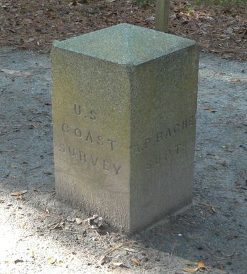
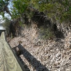
Alexander Bache U.S. Coast Survey Line, Historic survey line at Edisto Island, Charleston County, United States.
This survey line on Edisto Island is a relic from the 19th century, extending over several miles with granite blocks marking navigation points for coastal mapping. The blocks sit at regular intervals and serve as physical evidence of an early surveying technique.
The survey line was established in 1850 as part of a major project to improve U.S. coastal maps. A team led by Alexander Dallas Bache set up these measurement marks to document the coast's exact position.
The survey line shows how important accurate coastal measurements became for shipping and navigation. Visitors can see along the granite markers how early surveyors used the landscape to create reliable navigation points.
The site is located on State Cabin Road on Edisto Island and can be reached by car, with the granite blocks visible at open locations. It is advisable to wear sturdy shoes and explore the surrounding area to discover the markers spread across several miles.
Buried beneath the ground at each end of the line are additional granite blocks that can only be uncovered through deliberate digging. These hidden markers show how surveyors created a double backup system for their measurements.
The community of curious travelers
AroundUs brings together thousands of curated places, local tips, and hidden gems, enriched daily by 60,000 contributors worldwide.