Enable Location

We need your location to show you interesting places around you

Discover nearby places

Find interesting locations and hidden gems around you

Precise directions

Get accurate directions and distances to places

Your location is never shared with other users. It's only used when you tap the location button.

Mary Jenkins Community Praise House

Log in to your account

Start exploring — it's free

Trusted by 61,818 travelers worldwide

Continue with Google
Continue with Apple
or

We will send you a code to connect

By continuing, you accept our Terms and Conditions and our Privacy Policy

Check your inbox

We've sent a pincode in your inbox. Please enter the code below.

Mary Jenkins Community Praise House

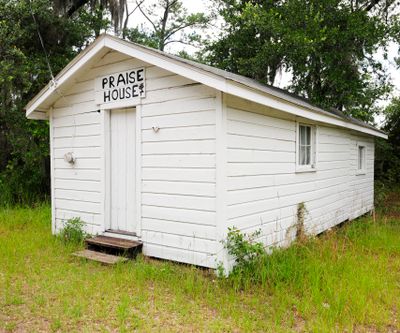
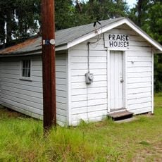
Mary Jenkins Community Praise House, Plantation-era worship building in St. Helena Island, South Carolina

Description

The Mary Jenkins Community Praise House is a wooden-frame structure with a gable roof and entrance positioned at the gable end on St. Helena Island. This simple building from the early 1900s continues to serve as a place for worship and community gathering.

History

Built around 1900 by Kit Chaplin, the praise house is one of four remaining structures of its kind from the post-plantation era on St. Helena Island. It represents religious independence that the community established after slavery.

Culture

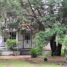
The praise house is where you can witness call-and-response singing and communal worship that embodies Gullah Geechee spiritual traditions. The way people gather here reflects beliefs passed down through families over many generations.

Practical

The praise house is located on Eddings Point Road on St. Helena Island and continues to function as an active worship and community meeting space. Visitors should be respectful, as this remains a place where the community regularly gathers.

Did you know?

A bell at the praise house has traditionally announced important community moments, from births to deaths to calls for worship services. This simple signaling system has linked residents together for many decades.

Location
GPS coordinates
32.42970,-80.56060
Latest update
December 14, 2025 18:00

AroundUs brings together thousands of curated places, local tips, and hidden gems, enriched daily by 60,000 contributors worldwide. Discover all places nearby (Beaufort County).

Around this place
Hunting Island State Park
United States of America

Hunting Island State Park

13 km
Beaufort National Cemetery
United States of America

Beaufort National Cemetery

11.2 km
Robert Smalls House
United States of America

Robert Smalls House

10.1 km
Penn School Historic District
United States of America

Penn School Historic District

4.8 km
Beaufort Historic District
United States of America

Beaufort Historic District

10.1 km
Reconstruction Era National Historical Park
United States of America

Reconstruction Era National Historical Park

10.3 km
St. Helena Parish Chapel of Ease Ruins
United States of America

St. Helena Parish Chapel of Ease Ruins

6.2 km
Coffin Point Plantation
United States of America

Coffin Point Plantation

8 km
Richard V. Woods Memorial Bridge
United States of America

Richard V. Woods Memorial Bridge

10.2 km
Marshlands
United States of America

Marshlands

9.9 km
Frogmore Plantation Complex
United States of America

Frogmore Plantation Complex

7.9 km
John Mark Verdier House
United States of America

John Mark Verdier House

10.4 km
Tabby Manse
United States of America

Tabby Manse

10.9 km
Barnwell-Gough House
United States of America

Barnwell-Gough House

10.5 km
The Anchorage
United States of America

The Anchorage

10.7 km
John A. Cuthbert House
United States of America

John A. Cuthbert House

10.8 km
Knights of Wise Men Lodge
United States of America

Knights of Wise Men Lodge

3.9 km
Sams Plantation Complex Tabby Ruins
United States of America

Sams Plantation Complex Tabby Ruins

3.2 km
Hunting Island Light
United States of America

Hunting Island Light

13 km
William Barnwell House
United States of America

William Barnwell House

10.5 km
Edgar Fripp Mausoleum, St. Helena Island Parish Church
United States of America

Edgar Fripp Mausoleum, St. Helena Island Parish Church

6.2 km
Coffin Point Plantation Caretaker's House
United States of America

Coffin Point Plantation Caretaker's House

8.2 km
Dr. York Bailey House
United States of America

Dr. York Bailey House

3.8 km
Eddings Point Community Praise House
United States of America

Eddings Point Community Praise House

2.2 km
The Green
United States of America

The Green

4 km
Emanuel Alston House
United States of America

Emanuel Alston House

3 km
Verdier House
United States of America

Verdier House

10.4 km
St. Helena Episcopal Church (Beaufort)
United States of America

St. Helena Episcopal Church (Beaufort)

10.7 km
Show the full map
« Mary Jenkins Community Praise House - Plantation-era worship building in St. Helena Island, South Carolina » is provided by Around Us (aroundus.com). Images and texts are derived from Wikimedia project under a Creative Commons license. You are allowed to copy, distribute, and modify copies of this page, under the conditions set by the license, as long as this note is clearly visible.

Discover hidden gems everywhere you go!

From secret cafés to breathtaking viewpoints, skip the crowded tourist spots and find places that match your style. Our app makes it easy with voice search, smart filtering, route optimization, and insider tips from travelers worldwide. Download now for the complete mobile experience.

Around Us App Screenshot

A unique approach to discovering new places

Le Figaro

All the places worth exploring

France Info

A tailor-made excursion in just a few clicks

20 Minutes

Around Us
Travel Guide & Maps
Download

Send to your phone

QR Code
1

Open the camera app on your mobile.

2

Point at the QR code with your camera. A notification will appear.

3

Tap the notification to open the link.