Sams Plantation Complex Tabby Ruins

Log in to your account

AroundUs is a community-driven map of interesting places, built by curious explorers like you. It grows with every review, story, and photo you share.
Connect to save your favorite spots, contribute locations, and create personalized routes.
Continue with Google
Continue with Apple
Continue with X
Continue with Facebook
Continue with email
By continuing, you accept our Terms and Conditions and our Privacy Policy
Create an account
Add to collection
Map
Suggest a change
Share

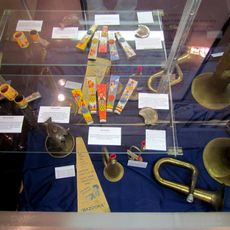
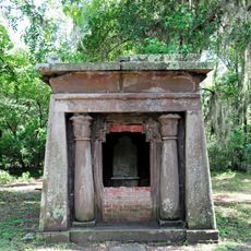
Sams Plantation Complex Tabby Ruins, Archaeological site from colonial period in Beaufort County, South Carolina.

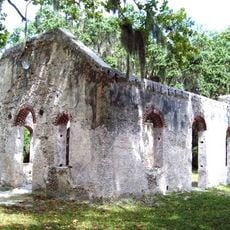
Sams Plantation Complex Tabby Ruins is a colonial-era archaeological site in Beaufort County containing twelve tabby structures across ten acres. The complex includes a main house, kitchen buildings, slave quarters, and various agricultural structures distributed across the property.

The Sams family established this plantation before 1783, growing indigo, cotton, and oranges with enslaved labor. The operation relied on a large workforce to maintain these crops and structures.

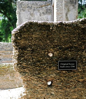
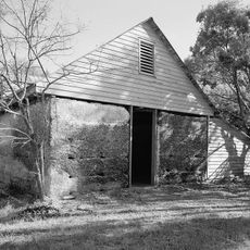
The structures show colonial-era tabby construction, a building method mixing oyster shells, lime, sand, and water that remains visible on site. This technique shaped regional architecture and allowed builders to create durable buildings.

The ruins are located at the southern end of Dataw Island near the intersection of Dataw Drive and Dataw Club Road. Visiting requires planning since site access may be limited and visitors should check conditions beforehand.

The site preserves the only known pitched tabby roof in the United States, positioned above the original smokehouse structure. This architectural detail shows how builders refined the construction technique and adapted it to more complex structures.

Location: Beaufort County

GPS coordinates: 32.43080,-80.59440

Latest update: December 14, 2025 16:43

Photos
Around this place
Beaufort National Cemetery
United States of America

Beaufort National Cemetery

8.1 km
Robert Smalls House
United States of America

Robert Smalls House

7 km
Penn School Historic District
United States of America

Penn School Historic District

5 km
Beaufort Historic District
United States of America

Beaufort Historic District

6.9 km
Reconstruction Era National Historical Park
United States of America

Reconstruction Era National Historical Park

7.2 km
St. Helena Parish Chapel of Ease Ruins
United States of America

St. Helena Parish Chapel of Ease Ruins

6.4 km
Coffin Point Plantation
United States of America

Coffin Point Plantation

11.2 km
Richard V. Woods Memorial Bridge
United States of America

Richard V. Woods Memorial Bridge

7 km
Marshlands
United States of America

Marshlands

6.7 km
The Kazoo Museum
United States of America

The Kazoo Museum

11.8 km
Frogmore Plantation Complex
United States of America

Frogmore Plantation Complex

8.6 km
John Mark Verdier House
United States of America

John Mark Verdier House

7.2 km
Tabby Manse
United States of America

Tabby Manse

7.7 km
Barnwell-Gough House
United States of America

Barnwell-Gough House

7.4 km
The Anchorage
United States of America

The Anchorage

7.5 km
John A. Cuthbert House
United States of America

John A. Cuthbert House

7.6 km
Knights of Wise Men Lodge
United States of America

Knights of Wise Men Lodge

4.8 km
Mary Jenkins Community Praise House
United States of America

Mary Jenkins Community Praise House

3.2 km
William Barnwell House
United States of America

William Barnwell House

7.3 km
Edgar Fripp Mausoleum, St. Helena Island Parish Church
United States of America

Edgar Fripp Mausoleum, St. Helena Island Parish Church

6.4 km
Coffin Point Plantation Caretaker's House
United States of America

Coffin Point Plantation Caretaker's House

11.4 km
Dr. York Bailey House
United States of America

Dr. York Bailey House

4.1 km
Eddings Point Community Praise House
United States of America

Eddings Point Community Praise House

4.9 km
Union Church of Port Royal
United States of America

Union Church of Port Royal

11 km
The Green
United States of America

The Green

4.2 km
Emanuel Alston House
United States of America

Emanuel Alston House

4.5 km
Verdier House
United States of America

Verdier House

7.2 km
St. Helena Episcopal Church (Beaufort)
United States of America

St. Helena Episcopal Church (Beaufort)

7.6 km
Show the full map
Reviews

Visited this place? Tap the stars to rate it and share your experience / photos with the community! Try now! You can cancel it anytime.

« Sams Plantation Complex Tabby Ruins - Archaeological site from colonial period in Beaufort County, South Carolina » is provided by Around Us (aroundus.com). Images and texts are derived from Wikimedia project under a Creative Commons license. You are allowed to copy, distribute, and modify copies of this page, under the conditions set by the license, as long as this note is clearly visible.

Discover hidden gems everywhere you go!

From secret cafés to breathtaking viewpoints, skip the crowded tourist spots and find places that match your style. Our app makes it easy with voice search, smart filtering, route optimization, and insider tips from travelers worldwide. Download now for the complete mobile experience.

Around Us App Screenshot

A unique approach to discovering new places

Le Figaro

All the places worth exploring

France Info

A tailor-made excursion in just a few clicks

20 Minutes