Enable Location

We need your location to show you interesting places around you

Discover nearby places

Find interesting locations and hidden gems around you

Precise directions

Get accurate directions and distances to places

Your location is never shared with other users. It's only used when you tap the location button.

Old Burying Ground

Log in to your account

Start exploring — it's free

Trusted by 62,455 travelers worldwide

Continue with Google
Continue with Apple
or

We will send you a code to connect

By continuing, you accept our Terms and Conditions and our Privacy Policy

Check your inbox

We've sent a pincode in your inbox. Please enter the code below.

Old Burying Ground, cemetery in Beaufort, North Carolina, USA

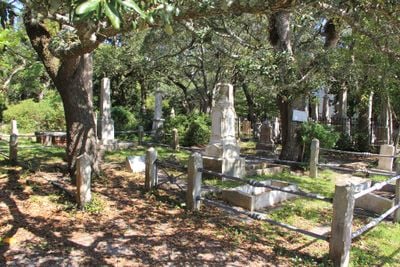
Old Burying Ground is the town's oldest cemetery, situated in the middle of Beaufort's historic district on Ann Street. The grounds contain hundreds of graves marked with stones, shells, bricks, and wooden slabs, with some featuring brick vaults built to protect the markers from water and decay over the centuries.

The cemetery began in the early 1700s as a burial place for the nearby St. John's Parish church. In 1731, Nathaniel Taylor donated the land to the town, officially establishing it as a public cemetery that served the growing community.

The cemetery reflects how early residents honored their dead with simple markers made from stone, shells, bricks, and wood based on what was locally available. These varied burial practices show the resourcefulness and daily choices of people who lived and worked on this coastal area.

The cemetery is open to visitors during daylight hours and can be explored on foot at your own pace. Self-guided maps are available at the gates, and organized tours are offered to help you understand the stories behind the graves and markers.

An unusual story involves a child who died at sea and was buried in a keg of rum, showing how sailors handled tragedy in their own way. Captain Otway Burns, a known privateer, and the crew of the schooner Crissie Wright, who perished in an 1886 storm at sea, also rest here.

The community of curious travelers

AroundUs brings together thousands of curated places, local tips, and hidden gems, enriched daily by 60,000 contributors worldwide.

Start exploring
Location
GPS coordinates
34.71860,-76.66420
Latest update
February 9, 2026 08:21
Around this place
Fort Macon State Park
United States of America

Fort Macon State Park

3.4 km
Cape Lookout Lighthouse
United States of America

Cape Lookout Lighthouse

16.7 km
Cape Lookout National Seashore
United States of America

Cape Lookout National Seashore

32 km
North Carolina Maritime Museum
United States of America

North Carolina Maritime Museum

209 m
United States of America

Neusiok Trail

17 km
Theodore Roosevelt State Natural Area
United States of America

Theodore Roosevelt State Natural Area

15.6 km
Harvey Mansion
United States of America

Harvey Mansion

54.9 km
Cape Lookout Village Historic District
United States of America

Cape Lookout Village Historic District

17.1 km
Cedar Island National Wildlife Refuge
United States of America

Cedar Island National Wildlife Refuge

43.5 km
China Grove
United States of America

China Grove

40.9 km
Cape Lookout Coast Guard Station
United States of America

Cape Lookout Coast Guard Station

17.3 km
Palo Alto Plantation
United States of America

Palo Alto Plantation

51.1 km
Ocracoke Historic District
United States of America

Ocracoke Historic District

52.9 km
Beaufort Historic District
United States of America

Beaufort Historic District

280 m
Morehead City Historic District
United States of America

Morehead City Historic District

4.6 km
Jacob Henry House
United States of America

Jacob Henry House

341 m
Gibbs House
United States of America

Gibbs House

683 m
Morehead City Municipal Building
United States of America

Morehead City Municipal Building

4.5 km
Mount Shiloh Missionary Baptist Church
United States of America

Mount Shiloh Missionary Baptist Church

52.8 km
Carteret County Home
United States of America

Carteret County Home

1.7 km
Core Sound Waterfowl Museum
United States of America

Core Sound Waterfowl Museum

12.9 km
Cape Lookout Visitor's Center
United States of America

Cape Lookout Visitor's Center

13.1 km
Keepers' Quarters Museum
United States of America

Keepers' Quarters Museum

16.6 km
Beaufort Historic Site
United States of America

Beaufort Historic Site

151 m
Havelock Tourist & Event Center
United States of America

Havelock Tourist & Event Center

30.7 km
Harkers Island Visitor Center
United States of America

Harkers Island Visitor Center

13.1 km
History Museum of Carteret County
United States of America

History Museum of Carteret County

4.8 km
Cape Lookout Lighthouse
United States of America

Cape Lookout Lighthouse

16.7 km
Show the full map
« Old Burying Ground - cemetery in Beaufort, North Carolina, USA » is provided by Around Us (aroundus.com). Images and texts are derived from Wikimedia project under a Creative Commons license. You are allowed to copy, distribute, and modify copies of this page, under the conditions set by the license, as long as this note is clearly visible.

Discover hidden gems everywhere you go!

From secret cafés to breathtaking viewpoints, skip the crowded tourist spots and find places that match your style. Our app makes it easy with voice search, smart filtering, route optimization, and insider tips from travelers worldwide. Download now for the complete mobile experience.

Around Us App Screenshot

A unique approach to discovering new places

Le Figaro

All the places worth exploring

France Info

A tailor-made excursion in just a few clicks

20 Minutes

Around Us
Travel Guide & Maps
Download

Send to your phone

QR Code
1

Open the camera app on your mobile.

2

Point at the QR code with your camera. A notification will appear.

3

Tap the notification to open the link.