Enable Location

We need your location to show you interesting places around you

Discover nearby places

Find interesting locations and hidden gems around you

Precise directions

Get accurate directions and distances to places

Your location is never shared with other users. It's only used when you tap the location button.

Forest Hills Historic District

Log in to your account

Start exploring — it's free

Trusted by 63,114 travelers worldwide

Continue with Google
Continue with Apple
or

We will send you a code to connect

By continuing, you accept our Terms and Conditions and our Privacy Policy

Check your inbox

We've sent a pincode in your inbox. Please enter the code below.

Discussion Reviews 1 Photos
10.6k Popularity

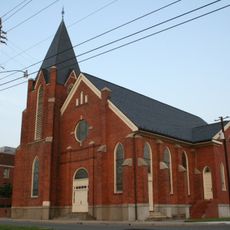
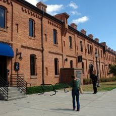
Forest Hills Historic District, Historic district in Durham, United States

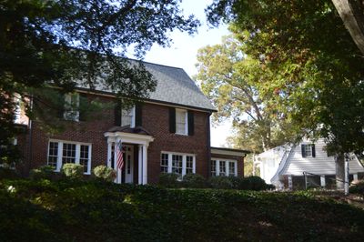
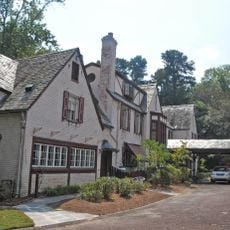
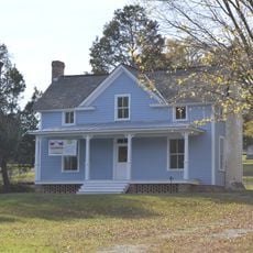
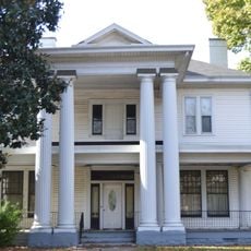
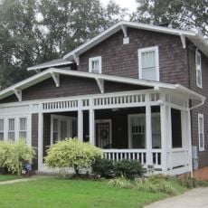
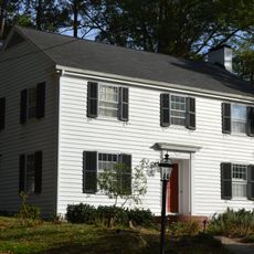
Forest Hills is a residential neighborhood in Durham covering 245 acres with over 300 buildings in Colonial Revival and Craftsman styles built between 1923 and 1955. Tree-lined streets and green spaces connect the homes, creating a coherent residential layout throughout the area.

The New Hope Realty Company developed Forest Hills in 1917 as Durham's first automobile suburb, designed by landscape architect Earl Sumner Draper. The neighborhood continued developing over following decades, reflecting changes in residential design and community needs.

The name Forest Hills reflects the rolling terrain and former golf course that shaped this neighborhood. Today, residents and visitors use the green spaces as gathering spots for walks, picnics, and recreation.

The neighborhood is centrally located in Durham between Kent Street, Bivins Street, and several boundary streets, making it accessible to explore on foot. Walking through at a comfortable pace allows you to notice the architectural details and street character.

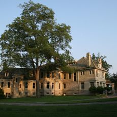
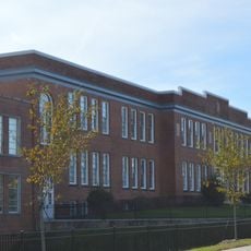
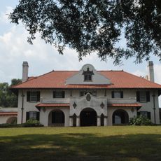
The former golf course clubhouse became home to Durham Academy in 1933 when Ann Hill founded the Calvert Method School there. This building marks an unexpected shift from recreation to education in the neighborhood's story.

The community of curious travelers

AroundUs brings together thousands of curated places, local tips, and hidden gems, enriched daily by 60,000 contributors worldwide.

Start exploring
Location
GPS coordinates
35.98190,-78.91470
Latest update
December 8, 2025 19:51
Around this place
11 foot 8 Bridge
United States of America

11 foot 8 Bridge

2 km
American Tobacco Trail
United States of America

American Tobacco Trail

1.2 km
Durham Performing Arts Center
United States of America

Durham Performing Arts Center

1.7 km
American Tobacco Historic District
United States of America

American Tobacco Historic District

1.7 km
Confederate Soldiers Monument
United States of America

Confederate Soldiers Monument

1.9 km
Hill Building
United States of America

Hill Building

2 km
Carolina Theatre
United States of America

Carolina Theatre

2.2 km
Mary Duke Biddle Estate
United States of America

Mary Duke Biddle Estate

427 m
W. T. Blackwell and Company Tobacco Factory
United States of America

W. T. Blackwell and Company Tobacco Factory

1.6 km
Durham County Justice Center
United States of America

Durham County Justice Center

1.5 km
21c Museum Hotel
United States of America

21c Museum Hotel

1.9 km
Pauli Murray Family Home
United States of America

Pauli Murray Family Home

1.2 km
North Carolina Mutual Life Insurance Company Building
United States of America

North Carolina Mutual Life Insurance Company Building

1.7 km
Emmanuel AME Church
United States of America

Emmanuel AME Church

1.4 km
Durham Centre
United States of America

Durham Centre

2.2 km
St. Joseph's African Methodist Episcopal Church
United States of America

St. Joseph's African Methodist Episcopal Church

1.6 km
The Tower at Mutual Plaza
United States of America

The Tower at Mutual Plaza

1.7 km
Downtown Durham Historic District
United States of America

Downtown Durham Historic District

2 km
Greystone
United States of America

Greystone

1.3 km
Scarborough House
United States of America

Scarborough House

1.3 km
Smith Warehouse
United States of America

Smith Warehouse

2.2 km
Somerhill Gallery
United States of America

Somerhill Gallery

1.7 km
Hillside Park High School
United States of America

Hillside Park High School

1.1 km
Burch Avenue Historic District
United States of America

Burch Avenue Historic District

1.8 km
Venable Tobacco Company Prizery and Receiving Room
United States of America

Venable Tobacco Company Prizery and Receiving Room

1.9 km
Morehead Hill Historic District
United States of America

Morehead Hill Historic District

885 m
Venable Tobacco Company Warehouse
United States of America

Venable Tobacco Company Warehouse

1.7 km
John Sprunt Hill House
United States of America

John Sprunt Hill House

972 m
Show the full map
Reviews
Share your experience

No review yet

Discussions
Start a discussion...

No discussion yet

« Forest Hills Historic District - Historic district in Durham, United States » is provided by Around Us (aroundus.com). Images and texts are derived from Wikimedia project under a Creative Commons license. You are allowed to copy, distribute, and modify copies of this page, under the conditions set by the license, as long as this note is clearly visible.

Discover hidden gems everywhere you go!

From secret cafés to breathtaking viewpoints, skip the crowded tourist spots and find places that match your style. Our app makes it easy with voice search, smart filtering, route optimization, and insider tips from travelers worldwide. Download now for the complete mobile experience.

Around Us App Screenshot

A unique approach to discovering new places

Le Figaro

All the places worth exploring

France Info

A tailor-made excursion in just a few clicks

20 Minutes

Around Us
Travel Guide & Maps
Download

Send to your phone

QR Code
1

Open the camera app on your mobile.

2

Point at the QR code with your camera. A notification will appear.

3

Tap the notification to open the link.