Enable Location

We need your location to show you interesting places around you

Discover nearby places

Find interesting locations and hidden gems around you

Precise directions

Get accurate directions and distances to places

Your location is never shared with other users. It's only used when you tap the location button.

American Tobacco Trail

Log in to your account

Start exploring — it's free

Trusted by 61,993 travelers worldwide

Continue with Google
Continue with Apple
or

We will send you a code to connect

By continuing, you accept our Terms and Conditions and our Privacy Policy

Check your inbox

We've sent a pincode in your inbox. Please enter the code below.

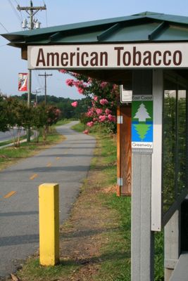
American Tobacco Trail, Rail trail and bike path in Durham, Chatham, and Wake Counties, United States.

The American Tobacco Trail is a rail-converted path stretching about 22.6 miles across Durham, Wake, and Chatham Counties. The trail features asphalt surfaces in some areas and stone dust in others, accommodating both cyclists and equestrians.

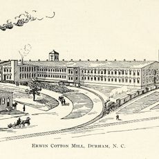
The trail follows a former Norfolk Southern Railway line that once transported tobacco company materials through the region in the early 1900s. The abandoned rail corridor was later transformed into a public recreational path.

The Triangle Rails-to-Trails Conservancy established in 1989 transformed this industrial railway corridor into a recreational path connecting multiple communities.

The trail is open from sunrise to sunset with parking access at several locations along the route. The different surface types mean you should wear appropriate footwear or bring a suitable bike for your planned activity.

The trail welcomes both cyclists and horse riders, making it unusual for accommodating multiple types of recreation in one place. This dual-use purpose is why different surface materials are maintained throughout its length.

The community of curious travelers

AroundUs brings together thousands of curated places, local tips, and hidden gems, enriched daily by 60,000 contributors worldwide.

Start exploring
Location
Location
Location
GPS coordinates
35.99048,-78.90632
Latest update
December 7, 2025 20:47
Around this place
11 foot 8 Bridge
United States of America

11 foot 8 Bridge

1 km
Durham Performing Arts Center
United States of America

Durham Performing Arts Center

487 m
Forest Hills Historic District
United States of America

Forest Hills Historic District

1.2 km
American Tobacco Historic District
United States of America

American Tobacco Historic District

557 m
Confederate Soldiers Monument
United States of America

Confederate Soldiers Monument

764 m
Hill Building
United States of America

Hill Building

752 m
Carolina Theatre
United States of America

Carolina Theatre

945 m
W. T. Blackwell and Company Tobacco Factory
United States of America

W. T. Blackwell and Company Tobacco Factory

416 m
Durham County Justice Center
United States of America

Durham County Justice Center

349 m
21c Museum Hotel
United States of America

21c Museum Hotel

734 m
Bright Leaf Historic District
United States of America

Bright Leaf Historic District

1.3 km
Pauli Murray Family Home
United States of America

Pauli Murray Family Home

894 m
North Carolina Mutual Life Insurance Company Building
United States of America

North Carolina Mutual Life Insurance Company Building

685 m
Emmanuel AME Church
United States of America

Emmanuel AME Church

1.2 km
Durham Centre
United States of America

Durham Centre

950 m
St. Joseph's African Methodist Episcopal Church
United States of America

St. Joseph's African Methodist Episcopal Church

872 m
The Tower at Mutual Plaza
United States of America

The Tower at Mutual Plaza

683 m
Downtown Durham Historic District
United States of America

Downtown Durham Historic District

740 m
Greystone
United States of America

Greystone

302 m
Bullington Warehouse
United States of America

Bullington Warehouse

1.4 km
Somerhill Gallery
United States of America

Somerhill Gallery

614 m
Hillside Park High School
United States of America

Hillside Park High School

983 m
Liberty Warehouse Nos. 1 and 2
United States of America

Liberty Warehouse Nos. 1 and 2

1.3 km
Burch Avenue Historic District
United States of America

Burch Avenue Historic District

1.3 km
Erwin Cotton Mills Company Mill No. 1 Headquarters Building
United States of America

Erwin Cotton Mills Company Mill No. 1 Headquarters Building

1.2 km
Morehead Hill Historic District
United States of America

Morehead Hill Historic District

590 m
Venable Tobacco Company Prizery and Receiving Room
United States of America

Venable Tobacco Company Prizery and Receiving Room

683 m
Venable Tobacco Company Warehouse
United States of America

Venable Tobacco Company Warehouse

592 m
Show the full map
« American Tobacco Trail - Rail trail and bike path in Durham, Chatham, and Wake Counties, United States » is provided by Around Us (aroundus.com). Images and texts are derived from Wikimedia project under a Creative Commons license. You are allowed to copy, distribute, and modify copies of this page, under the conditions set by the license, as long as this note is clearly visible.

Discover hidden gems everywhere you go!

From secret cafés to breathtaking viewpoints, skip the crowded tourist spots and find places that match your style. Our app makes it easy with voice search, smart filtering, route optimization, and insider tips from travelers worldwide. Download now for the complete mobile experience.

Around Us App Screenshot

A unique approach to discovering new places

Le Figaro

All the places worth exploring

France Info

A tailor-made excursion in just a few clicks

20 Minutes

Around Us
Travel Guide & Maps
Download

Send to your phone

QR Code
1

Open the camera app on your mobile.

2

Point at the QR code with your camera. A notification will appear.

3

Tap the notification to open the link.