Chest opened
+${chestReward.xp} XP
Explorer
NOUVEAU ×${chestReward.collectible.quantity}
tapez pour fermer
Chest locked

Open chests in the app

Around Us is built for your phone — chests unlock when you walk, explore and capture nearby places.

Enable Location

We need your location to show you interesting places around you

Discover nearby places

Find interesting locations and hidden gems around you

Precise directions

Get accurate directions and distances to places

Your location is never shared with other users. It's only used when you tap the location button.

Log in to your account

Start exploring — it's free

Trusted by 72,923 travelers worldwide

Continue with Google
Continue with Apple
or

We will send you a code to connect

By continuing, you accept our Terms and Conditions and our Privacy Policy

Check your inbox

We've sent a pincode in your inbox. Please enter the code below.

Tom Mix Wash
Discussion Reviews Photo
2.5k Popularity

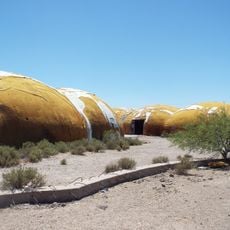
Tom Mix Wash, Desert stream in Pinal County, Arizona

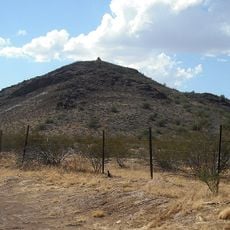
Tom Mix Wash is a desert streambed in the Sonoran Desert landscape of Pinal County, Arizona, that carries water during seasonal rainfall. The channel cuts through arid terrain and reveals the natural drainage patterns that shape this dry region.

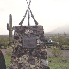
The streambed was named after silent film actor Tom Mix, who died in a car accident near this location in 1940. The name preserves the connection between a Hollywood star and this remote desert location.

The wash stands as a memorial to early Western cinema, connecting the natural landscape with the legacy of American film entertainment from the 1920s.

Visitors should bring plenty of water and check weather conditions, as flash floods can occur following rainfall in the area. The best time to explore is during the drier months when the terrain is safer to navigate.

Tom Mix was one of the highest-paid film stars of the 1920s, yet his name now marks a quiet desert location that recalls his sudden death. Despite its significance, this place remains unknown to most travelers passing through the Arizona wilderness.

The community of curious travelers

AroundUs brings together thousands of curated places, local tips, and hidden gems, enriched daily by 60,000 contributors worldwide.

Start exploring
Location
Location
GPS coordinates
32.84560,-111.31310
Latest update
December 12, 2025 17:43
Around this place
Casa Grande Ruins National Monument
United States of America

Casa Grande Ruins National Monument

26.5 km
Picacho Peak State Park
United States of America

Picacho Peak State Park

25.7 km
St. Anthony's Greek Orthodox Monastery
United States of America

St. Anthony's Greek Orthodox Monastery

9.6 km
Corona Satellite Calibration Targets
United States of America

Corona Satellite Calibration Targets

40.7 km
Poston Butte
United States of America

Poston Butte

25 km
McFarland State Historic Park
United States of America

McFarland State Historic Park

22.3 km
Florence High School
United States of America

Florence High School

20.9 km
Second Pinal County Courthouse
United States of America

Second Pinal County Courthouse

21.8 km
C.H. Cook Memorial Church
United States of America

C.H. Cook Memorial Church

47.7 km
Casa Grande Stone Church
United States of America

Casa Grande Stone Church

41.4 km
First Baptist Church
United States of America

First Baptist Church

41.1 km
Casa Grande Woman's Club Building
United States of America

Casa Grande Woman's Club Building

41.5 km
Saint Anthony's Church
United States of America

Saint Anthony's Church

41.2 km
White House
United States of America

White House

40.7 km
First Presbyterian Church of Florence
United States of America

First Presbyterian Church of Florence

21.7 km
Valley National Bank
United States of America

Valley National Bank

41.2 km
Cruz Trading Post
United States of America

Cruz Trading Post

41.5 km
Building at 400 East Third Street
United States of America

Building at 400 East Third Street

41 km
Harvey-Niemeyer House
United States of America

Harvey-Niemeyer House

21.6 km
Henry and Anna Kochsmeier House
United States of America

Henry and Anna Kochsmeier House

41.9 km
Walter Wilbur House
United States of America

Walter Wilbur House

40.4 km
Casa Grande Hospital
United States of America

Casa Grande Hospital

40.8 km
The Domes of Casa Grande
United States of America

The Domes of Casa Grande

43.2 km
McFarland State Historic Park
United States of America

McFarland State Historic Park

22.3 km
The Golf Club at Johnson Ranch
United States of America

The Golf Club at Johnson Ranch

41.9 km
Paramount Theatre
United States of America

Paramount Theatre

41.2 km
Casa Grande City Hall
United States of America

Casa Grande City Hall

40.8 km
Isis Theatre
United States of America

Isis Theatre

22.2 km
Show the full map
Reviews
Share your experience

No review yet

Discussions
Start a discussion...

No discussion yet

« Tom Mix Wash - Desert stream in Pinal County, Arizona » is provided by Around Us (aroundus.com). Images and texts are derived from Wikimedia project under a Creative Commons license. You are allowed to copy, distribute, and modify copies of this page, under the conditions set by the license, as long as this note is clearly visible.

Discover hidden gems everywhere you go!

From secret cafés to breathtaking viewpoints, skip the crowded tourist spots and find places that match your style. Our app makes it easy with voice search, smart filtering, route optimization, and insider tips from travelers worldwide. Download now for the complete mobile experience.

Around Us App Screenshot

A unique approach to discovering new places

Le Figaro

All the places worth exploring

France Info

A tailor-made excursion in just a few clicks

20 Minutes

Around Us
Travel Guide & Maps
Download

Send to your phone

QR Code
1

Open the camera app on your mobile.

2

Point at the QR code with your camera. A notification will appear.

3

Tap the notification to open the link.