Enable Location

We need your location to show you interesting places around you

Discover nearby places

Find interesting locations and hidden gems around you

Precise directions

Get accurate directions and distances to places

Your location is never shared with other users. It's only used when you tap the location button.

Cedar Crossing Bridge

Log in to your account

Start exploring — it's free

Trusted by 62,339 travelers worldwide

Continue with Google
Continue with Apple
or

We will send you a code to connect

By continuing, you accept our Terms and Conditions and our Privacy Policy

Check your inbox

We've sent a pincode in your inbox. Please enter the code below.

Cedar Crossing Bridge

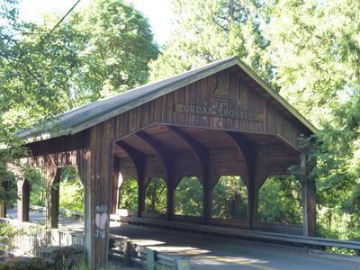
Cedar Crossing Bridge, Covered bridge in Multnomah County, Oregon, US

Cedar Crossing Bridge is a covered structure crossing Johnson Creek with large windows positioned along its sides for natural light. The interior is finished with knotty pine wood, creating a warm appearance throughout the passage.

The bridge was constructed in 1982 to replace an older wooden structure that had become unsafe for use. This project marked a major infrastructure update for the area.

The structure blends practical engineering with traditional covered bridge aesthetics seen throughout the region. A dedicated pedestrian walkway allows visitors to experience the crossing safely alongside vehicle traffic.

The bridge can be reached by heading east on Foster Road from Interstate 205, then turning south onto Southeast 132nd Street. Deardorf Road provides direct access to the crossing point.

Unlike historical covered bridges, this structure does not rely on traditional wooden truss systems for support underneath. The design instead employs modern engineering methods that set it apart from its older counterparts throughout the region.

The community of curious travelers

AroundUs brings together thousands of curated places, local tips, and hidden gems, enriched daily by 60,000 contributors worldwide.

Start exploring
Location
Official opening
1982
GPS coordinates
45.47203,-122.52372
Latest update
December 14, 2025 14:42
« Cedar Crossing Bridge - Covered bridge in Multnomah County, Oregon, US » is provided by Around Us (aroundus.com). Images and texts are derived from Wikimedia project under a Creative Commons license. You are allowed to copy, distribute, and modify copies of this page, under the conditions set by the license, as long as this note is clearly visible.

Discover hidden gems everywhere you go!

From secret cafés to breathtaking viewpoints, skip the crowded tourist spots and find places that match your style. Our app makes it easy with voice search, smart filtering, route optimization, and insider tips from travelers worldwide. Download now for the complete mobile experience.

Around Us App Screenshot

A unique approach to discovering new places

Le Figaro

All the places worth exploring

France Info

A tailor-made excursion in just a few clicks

20 Minutes

Around Us
Travel Guide & Maps
Download

Send to your phone

QR Code
1

Open the camera app on your mobile.

2

Point at the QR code with your camera. A notification will appear.

3

Tap the notification to open the link.