Chest opened
+${chestReward.xp} XP
Explorer
NOUVEAU ×${chestReward.collectible.quantity}
tapez pour fermer
Chest locked

Open chests in the app

Around Us is built for your phone — chests unlock when you walk, explore and capture nearby places.

Enable Location

We need your location to show you interesting places around you

Discover nearby places

Find interesting locations and hidden gems around you

Precise directions

Get accurate directions and distances to places

Your location is never shared with other users. It's only used when you tap the location button.

Log in to your account

Start exploring — it's free

Trusted by 72,880 travelers worldwide

Continue with Google
Continue with Apple
or

We will send you a code to connect

By continuing, you accept our Terms and Conditions and our Privacy Policy

Check your inbox

We've sent a pincode in your inbox. Please enter the code below.

Hoover-Mason Trestle
Discussion Reviews Photo
2.2k Popularity

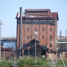
Hoover-Mason Trestle, Elevated park and railway bridge in Bethlehem, United States.

The Hoover-Mason Trestle is an elevated walkway built over the former steel mill grounds, offering views of five preserved blast furnaces from above. The structure sits among machinery, pipes, and industrial equipment that show how the steelworks operated.

Built in 1905, this narrow gauge railway transported raw materials from the Lehigh River to the steel mill's blast furnaces. The transport system was critical to steel production throughout the 20th century.

The site reflects the steel industry that once shaped life in this city and region. Walking the elevated path, you encounter reminders of the work and communities that depended on this production.

Access the walkway through stairs or an elevator at the Bethlehem Visitor Center, where the route is well marked. The best time to walk is in the morning or mid-afternoon, when sunlight shows the industrial surroundings most clearly.

The steel mill produced material for the Golden Gate Bridge and numerous World War II naval vessels. The trestle still displays the railway infrastructure that moved these raw materials across the mill.

The community of curious travelers

AroundUs brings together thousands of curated places, local tips, and hidden gems, enriched daily by 60,000 contributors worldwide.

Start exploring
Location
GPS coordinates
40.61505,-75.36492
Latest update
December 13, 2025 17:06
Around this place
Martin Tower
United States of America

Martin Tower

3.1 km
Goodman Stadium
United States of America

Goodman Stadium

3 km
Stabler Arena
United States of America

Stabler Arena

3.5 km
Lost River Caverns
United States of America

Lost River Caverns

4.8 km
Neuweiler Brewery
United States of America

Neuweiler Brewery

7.9 km
Hill to Hill Bridge
United States of America

Hill to Hill Bridge

1.7 km
Central Park
United States of America

Central Park

4.8 km
Bethlehem Waterworks
United States of America

Bethlehem Waterworks

1.6 km
America On Wheels
United States of America

America On Wheels

7.4 km
Historic Moravian Bethlehem Historic District
United States of America

Historic Moravian Bethlehem Historic District

1.4 km
Burnside Plantation
United States of America

Burnside Plantation

2.7 km
Pembroke Village
United States of America

Pembroke Village

1.8 km
Cathedral Church of the Nativity
United States of America

Cathedral Church of the Nativity

1.6 km
Philip J. Fahy Memorial Bridge
United States of America

Philip J. Fahy Memorial Bridge

1.2 km
Gemeinhaus-Lewis David de Schweinitz Residence
United States of America

Gemeinhaus-Lewis David de Schweinitz Residence

1.4 km
Central Bethlehem Historic District
United States of America

Central Bethlehem Historic District

1.5 km
Sky Zone Bethlehem
United States of America

Sky Zone Bethlehem

4.4 km
South Bethlehem Downtown Historic District
United States of America

South Bethlehem Downtown Historic District

898 m
Fountain Hill Historic District
United States of America

Fountain Hill Historic District

1.8 km
Illick's Mill
United States of America

Illick's Mill

3.3 km
Lutz-Franklin School
United States of America

Lutz-Franklin School

7.3 km
Elmwood Park Historic District
United States of America

Elmwood Park Historic District

1 km
Michael and Margaret Heller House
United States of America

Michael and Margaret Heller House

4.3 km
Gristmiller's House
United States of America

Gristmiller's House

1.7 km
Ehrhart's Mill Historic District
United States of America

Ehrhart's Mill Historic District

6.1 km
National Museum of Industrial History
United States of America

National Museum of Industrial History

572 m
Minsi Trail Bridge
United States of America

Minsi Trail Bridge

600 m
Movies
United States of America

Movies

3.8 km
Show the full map
Reviews
Share your experience

No review yet

Discussions
Start a discussion...

No discussion yet

« Hoover-Mason Trestle - Elevated park and railway bridge in Bethlehem, United States » is provided by Around Us (aroundus.com). Images and texts are derived from Wikimedia project under a Creative Commons license. You are allowed to copy, distribute, and modify copies of this page, under the conditions set by the license, as long as this note is clearly visible.

Discover hidden gems everywhere you go!

From secret cafés to breathtaking viewpoints, skip the crowded tourist spots and find places that match your style. Our app makes it easy with voice search, smart filtering, route optimization, and insider tips from travelers worldwide. Download now for the complete mobile experience.

Around Us App Screenshot

A unique approach to discovering new places

Le Figaro

All the places worth exploring

France Info

A tailor-made excursion in just a few clicks

20 Minutes

Around Us
Travel Guide & Maps
Download

Send to your phone

QR Code
1

Open the camera app on your mobile.

2

Point at the QR code with your camera. A notification will appear.

3

Tap the notification to open the link.