Chest opened
+${chestReward.xp} XP
Explorer
NOUVEAU ×${chestReward.collectible.quantity}
tapez pour fermer
Chest locked

Open chests in the app

Around Us is built for your phone — chests unlock when you walk, explore and capture nearby places.

Enable Location

We need your location to show you interesting places around you

Discover nearby places

Find interesting locations and hidden gems around you

Precise directions

Get accurate directions and distances to places

Your location is never shared with other users. It's only used when you tap the location button.

Log in to your account

Start exploring — it's free

Trusted by 72,952 travelers worldwide

Continue with Google
Continue with Apple
or

We will send you a code to connect

By continuing, you accept our Terms and Conditions and our Privacy Policy

Check your inbox

We've sent a pincode in your inbox. Please enter the code below.

Ireteba Peaks Wilderness
Discussion Reviews Photo
1.4k Popularity

Ireteba Peaks Wilderness, Protected wilderness area in southern Nevada, US.

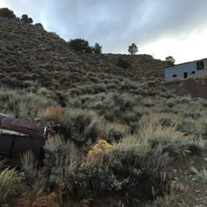
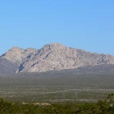
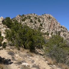
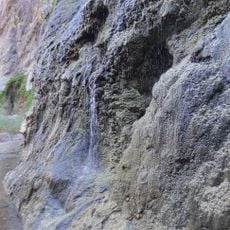
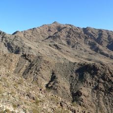
Ireteba Peaks Wilderness is a protected desert area in southern Nevada featuring steep canyons and wide bajadas that slope toward Lake Mohave. The landscape is shaped by jagged ridges and rock formations that create dramatic elevation changes across the terrain.

The area was named after Ireteba, a Mohave leader who guided Lieutenant J.C. Ives during a Colorado River expedition in the 1800s. This historical connection was later honored by establishing the land as a protected wilderness.

The National Park Service and Bureau of Land Management jointly manage this natural reserve, preserving its native Mojave Desert ecosystem and geological formations.

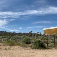
Visitors can access the area via dirt roads from Nelson Road in the north or Cottonwood Cove Road in the south. Motorized vehicles are not permitted throughout the wilderness, so prepare for hiking on foot with proper boots and ample water.

The area is home to desert tortoises and bighorn sheep that thrive in this protected habitat. The variety of cacti and other adapted plants demonstrates the resilience of the Mojave ecosystem.

The community of curious travelers

AroundUs brings together thousands of curated places, local tips, and hidden gems, enriched daily by 60,000 contributors worldwide.

Start exploring
GPS coordinates
35.59443,-114.82887
Latest update
December 14, 2025 16:40
Around this place
Hoover Dam
United States of America

Hoover Dam

47.6 km
Mike O'Callaghan–Pat Tillman Memorial Bridge
United States of America

Mike O'Callaghan–Pat Tillman Memorial Bridge

47.2 km
Desperado
United States of America

Desperado

50.3 km
Black Canyon of the Colorado
United States of America

Black Canyon of the Colorado

25.8 km
Castle Mountains National Monument
United States of America

Castle Mountains National Monument

39.9 km
United States of America

Black Mountain

42.2 km
Sloan Canyon National Conservation Area
United States of America

Sloan Canyon National Conservation Area

38.6 km
El Dorado Canyon
United States of America

El Dorado Canyon

16.7 km
Grapevine Canyon Petroglyphs
United States of America

Grapevine Canyon Petroglyphs

42.9 km
Eldorado Casino
United States of America

Eldorado Casino

50.7 km
Nevada Southern Railroad Museum
United States of America

Nevada Southern Railroad Museum

42 km
Spirit Mountain
United States of America

Spirit Mountain

36.8 km
Spirit Mountain Wilderness
United States of America

Spirit Mountain Wilderness

40.2 km
United States of America

Bridge Canyon Wilderness

42.4 km
Boulder City Historic District
United States of America

Boulder City Historic District

42.7 km
Gold Strike Hot Springs
United States of America

Gold Strike Hot Springs

45.8 km
Grapevine Canyon
United States of America

Grapevine Canyon

42.9 km
Willow Beach Gauging Station
United States of America

Willow Beach Gauging Station

35.3 km
Mount Wilson
United States of America

Mount Wilson

48.9 km
Wee Thump Joshua Tree Wilderness, Nevada
United States of America

Wee Thump Joshua Tree Wilderness, Nevada

25.5 km
Dig This
United States of America

Dig This

50.3 km
Seven Magic Mountains
United States of America

Seven Magic Mountains

48.4 km
Shan-Gri-La Prehistoric Park (aka the Dinosaur House)
United States of America

Shan-Gri-La Prehistoric Park (aka the Dinosaur House)

47.7 km
Winged Figures of the Republic
United States of America

Winged Figures of the Republic

47.7 km
Boulder Theatre
United States of America

Boulder Theatre

42.7 km
Hoover Dam Exhibits
United States of America

Hoover Dam Exhibits

47.7 km
Hoover Dam Visitor Center
United States of America

Hoover Dam Visitor Center

47.6 km
Alan Bible Visitor Center
United States of America

Alan Bible Visitor Center

46.3 km
Show the full map
Reviews
Share your experience

No review yet

Discussions
Start a discussion...

No discussion yet

« Ireteba Peaks Wilderness - Protected wilderness area in southern Nevada, US » is provided by Around Us (aroundus.com). Images and texts are derived from Wikimedia project under a Creative Commons license. You are allowed to copy, distribute, and modify copies of this page, under the conditions set by the license, as long as this note is clearly visible.

Discover hidden gems everywhere you go!

From secret cafés to breathtaking viewpoints, skip the crowded tourist spots and find places that match your style. Our app makes it easy with voice search, smart filtering, route optimization, and insider tips from travelers worldwide. Download now for the complete mobile experience.

Around Us App Screenshot

A unique approach to discovering new places

Le Figaro

All the places worth exploring

France Info

A tailor-made excursion in just a few clicks

20 Minutes

Around Us
Travel Guide & Maps
Download

Send to your phone

QR Code
1

Open the camera app on your mobile.

2

Point at the QR code with your camera. A notification will appear.

3

Tap the notification to open the link.