Mike O'Callaghan–Pat Tillman Memorial Bridge

Log in to your account

AroundUs is a community-driven map of interesting places, built by curious explorers like you. It grows with every review, story, and photo you share.
Connect to save your favorite spots, contribute locations, and create personalized routes.
Continue with Google
Continue with Apple
Continue with X
Continue with Facebook
Continue with email
By continuing, you accept our Terms and Conditions and our Privacy Policy
Create an account

Mike O'Callaghan–Pat Tillman Memorial Bridge

Add to collection
Map
Suggest a change
Share

Mike O'Callaghan–Pat Tillman Memorial Bridge, Arch bridge near Boulder City, United States.

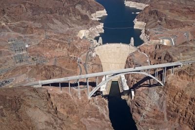
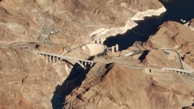
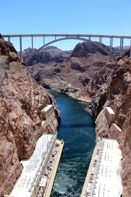
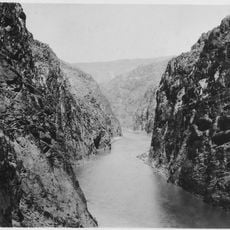
The Mike O'Callaghan–Pat Tillman Memorial Bridge is a reinforced concrete arch bridge in Mohave County and Clark County that stretches 579 meters across the Colorado River, linking Nevada and Arizona. The roadway sits 270 meters (886 feet) above the water and offers pedestrians a direct view into the Black Canyon and down to the dam below.

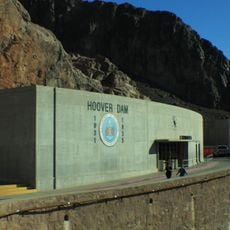
Construction began in 2005 and finished in 2010, replacing a route that had run directly over the dam for decades. The new crossing relieved congestion and improved safety for traffic moving between the two states.

The crossing honors Mike O'Callaghan, who served as Nevada's governor, and Pat Tillman, a professional football player who joined the military and lost his life in Afghanistan. Their names link public service, sport, and military sacrifice in a single memorial structure.

Pedestrian walkways run along both sides of the crossing, allowing visitors to walk out over the canyon and take in the scale of the gorge below. The paths provide safe access to observation points and make it easy to photograph both the structure and the surrounding landscape.

This crossing contains the widest concrete arches in the Western Hemisphere and represents the first composite structure of its kind built in the United States. The design allowed engineers to span the canyon at record height while maintaining stability in desert winds.

Location: Mohave County

Location: Clark County

Inception: October 14, 2010

Official opening: October 16, 2010

Length: 579 m

Longest Span: 323 m

Made from material: reinforced concrete

Part of: Hoover Dam Bypass

GPS coordinates: 36.01250,-114.74139

Latest update: December 13, 2025 15:36

Photos
Around this place
Hoover Dam
United States of America

Hoover Dam

493 m
Sam Boyd Stadium
United States of America

Sam Boyd Stadium

26.1 km
Lake Las Vegas
United States of America

Lake Las Vegas

19.6 km
Ethel M Chocolate Factory
United States of America

Ethel M Chocolate Factory

30.7 km
Sam's Town Hotel and Gambling Hall, Las Vegas
United States of America

Sam's Town Hotel and Gambling Hall, Las Vegas

30.9 km
Black Canyon of the Colorado
United States of America

Black Canyon of the Colorado

23.2 km
Clark County Heritage Museum
United States of America

Clark County Heritage Museum

18.3 km
United States of America

Black Mountain

28.7 km
Sloan Canyon National Conservation Area
United States of America

Sloan Canyon National Conservation Area

28.1 km
Clark County Wetlands Park
United States of America

Clark County Wetlands Park

27.2 km
Eastside Cannery
United States of America

Eastside Cannery

30.2 km
The District at Green Valley Ranch
United States of America

The District at Green Valley Ranch

31.1 km
Sunrise Mountain
United States of America

Sunrise Mountain

32.5 km
Henderson Pavilion
United States of America

Henderson Pavilion

30.6 km
Acacia Demonstration Gardens
United States of America

Acacia Demonstration Gardens

24.7 km
Boulder City Historic District
United States of America

Boulder City Historic District

9.2 km
Gold Strike Hot Springs
United States of America

Gold Strike Hot Springs

1.5 km
Mount Wilson
United States of America

Mount Wilson

11.8 km
Nevada State Railroad Museum Boulder City
United States of America

Nevada State Railroad Museum Boulder City

11.2 km
Emerald Cove
United States of America

Emerald Cove

14.6 km
Shan-Gri-La Prehistoric Park (aka the Dinosaur House)
United States of America

Shan-Gri-La Prehistoric Park (aka the Dinosaur House)

21.2 km
Winged Figures of the Republic
United States of America

Winged Figures of the Republic

511 m
Hoover Dam Exhibits
United States of America

Hoover Dam Exhibits

554 m
Boulder Theatre
United States of America

Boulder Theatre

9.3 km
Liberty Bell Arch
United States of America

Liberty Bell Arch

4.5 km
Hoover Dam Visitor Center
United States of America

Hoover Dam Visitor Center

438 m
Swim Beach
United States of America

Swim Beach

6.3 km
North Beach
United States of America

North Beach

6.5 km
Show the full map
Reviews

Visited this place? Tap the stars to rate it and share your experience / photos with the community! Try now! You can cancel it anytime.

« Mike O'Callaghan–Pat Tillman Memorial Bridge - Arch bridge near Boulder City, United States » is provided by Around Us (aroundus.com). Images and texts are derived from Wikimedia project under a Creative Commons license. You are allowed to copy, distribute, and modify copies of this page, under the conditions set by the license, as long as this note is clearly visible.

Discover hidden gems everywhere you go!

From secret cafés to breathtaking viewpoints, skip the crowded tourist spots and find places that match your style. Our app makes it easy with voice search, smart filtering, route optimization, and insider tips from travelers worldwide. Download now for the complete mobile experience.

Around Us App Screenshot

A unique approach to discovering new places

Le Figaro

All the places worth exploring

France Info

A tailor-made excursion in just a few clicks

20 Minutes