Chest opened
+${chestReward.xp} XP
Explorer
NOUVEAU ×${chestReward.collectible.quantity}
tapez pour fermer
Chest locked

Open chests in the app

Around Us is built for your phone — chests unlock when you walk, explore and capture nearby places.

Enable Location

We need your location to show you interesting places around you

Discover nearby places

Find interesting locations and hidden gems around you

Precise directions

Get accurate directions and distances to places

Your location is never shared with other users. It's only used when you tap the location button.

Log in to your account

Start exploring — it's free

Trusted by 73,002 travelers worldwide

Continue with Google
Continue with Apple
or

We will send you a code to connect

By continuing, you accept our Terms and Conditions and our Privacy Policy

Check your inbox

We've sent a pincode in your inbox. Please enter the code below.

C.W. Bill Jones Pumping Plant
Discussion Reviews Photo
1.9k Popularity

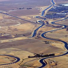
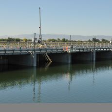
C.W. Bill Jones Pumping Plant, Water pumping facility in Tracy, California, US

The C.W. Bill Jones Pumping Plant is a water facility in Tracy, California that moves water from the Sacramento River into the Delta-Mendota Canal system. Six large electrical motors power the operation, each capable of lifting enormous quantities of water to higher elevations across the region.

The facility was built between 1947 and 1951 as part of a major federal water project designed to serve the San Joaquin Valley region. Since opening, it has played a key role in managing water supplies for agricultural and urban areas across central California.

The plant honors C.W. Bill Jones, a California farmer who dedicated his career to agricultural water management and served on multiple water authorities.

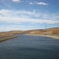
The facility is visible from the road and can be observed from outside, with the large exterior structures clearly visible to passersby. Keep in mind this is an active industrial operation, so access to certain areas may be restricted for safety reasons.

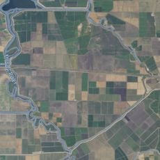
Water travels roughly 50 miles through natural waterways after being lifted by the pumps before reaching agricultural areas. This long journey allows the water to distribute gradually across different canal routes.

The community of curious travelers

AroundUs brings together thousands of curated places, local tips, and hidden gems, enriched daily by 60,000 contributors worldwide.

Start exploring
GPS coordinates
37.79660,-121.58549
Latest update
December 14, 2025 11:01
Around this place
Centennial Light
United States of America

Centennial Light

18.7 km
California Aqueduct
United States of America

California Aqueduct

4.5 km
Altamont Raceway Park
United States of America

Altamont Raceway Park

6.8 km
Altamont Pass
United States of America

Altamont Pass

8.5 km
Black Diamond Mines Regional Preserve
United States of America

Black Diamond Mines Regional Preserve

29.4 km
Antioch Bridge
United States of America

Antioch Bridge

29.2 km
Blackhawk Museum
United States of America

Blackhawk Museum

29.2 km
USS Lucid
United States of America

USS Lucid

27.6 km
Franks Tract State Recreation Area
United States of America

Franks Tract State Recreation Area

28.5 km
Del Valle Regional Park
United States of America

Del Valle Regional Park

24.7 km
Stone House of John Marsh
United States of America

Stone House of John Marsh

16.1 km
Mokelumne Aqueduct
United States of America

Mokelumne Aqueduct

18.6 km
Wiley’s Waterpark
United States of America

Wiley’s Waterpark

28.5 km
Contra Costa Canal
United States of America

Contra Costa Canal

24.4 km
Marsh Creek State Park
United States of America

Marsh Creek State Park

17.1 km
Bethany Reservoir
United States of America

Bethany Reservoir

3.2 km
Boomers Livermore
United States of America

Boomers Livermore

22.5 km
Jones Tract
United States of America

Jones Tract

17.9 km
Livermore Carnegie Library and Park
United States of America

Livermore Carnegie Library and Park

20.7 km
Shannon-Williamson Ranch
United States of America

Shannon-Williamson Ranch

24 km
Doolan Canyon
United States of America

Doolan Canyon

23.3 km
Bank of Tracy
United States of America

Bank of Tracy

15.6 km
Bank of Italy
United States of America

Bank of Italy

15.7 km
Tracy City Hall and Jail
United States of America

Tracy City Hall and Jail

15.6 km
Antioch WaterPark
United States of America

Antioch WaterPark

24.9 km
Del Valle East Beach
United States of America

Del Valle East Beach

25.7 km
Shadow Cliffs Beach
United States of America

Shadow Cliffs Beach

26.6 km
Regal Hacienda Crossings Stadium 20 & IMAX
United States of America

Regal Hacienda Crossings Stadium 20 & IMAX

28.4 km
Show the full map
Reviews
Share your experience

No review yet

Discussions
Start a discussion...

No discussion yet

« C.W. Bill Jones Pumping Plant - Water pumping facility in Tracy, California, US » is provided by Around Us (aroundus.com). Images and texts are derived from Wikimedia project under a Creative Commons license. You are allowed to copy, distribute, and modify copies of this page, under the conditions set by the license, as long as this note is clearly visible.

Discover hidden gems everywhere you go!

From secret cafés to breathtaking viewpoints, skip the crowded tourist spots and find places that match your style. Our app makes it easy with voice search, smart filtering, route optimization, and insider tips from travelers worldwide. Download now for the complete mobile experience.

Around Us App Screenshot

A unique approach to discovering new places

Le Figaro

All the places worth exploring

France Info

A tailor-made excursion in just a few clicks

20 Minutes

Around Us
Travel Guide & Maps
Download

Send to your phone

QR Code
1

Open the camera app on your mobile.

2

Point at the QR code with your camera. A notification will appear.

3

Tap the notification to open the link.