Enable Location

We need your location to show you interesting places around you

Discover nearby places

Find interesting locations and hidden gems around you

Precise directions

Get accurate directions and distances to places

Your location is never shared with other users. It's only used when you tap the location button.

Log in to your account

Start exploring — it's free

Trusted by 63,038 travelers worldwide

Continue with Google
Continue with Apple
or

We will send you a code to connect

By continuing, you accept our Terms and Conditions and our Privacy Policy

Check your inbox

We've sent a pincode in your inbox. Please enter the code below.

Galesville Reservoir
Discussion Reviews Photo
2.6k Popularity

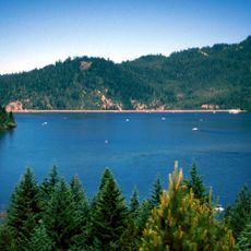
Galesville Reservoir, water storage reservoir in galesville

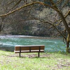
Galesville Reservoir is a man-made lake in southern Douglas County, Oregon, created by damming the Cow Creek. The lake contains multiple fish species including bass, trout, crappie, sunfish, and catfish, spread across a wide surface surrounded by forested banks.

The dam was completed in 1986 to control flooding and generate electricity for the surrounding area. It also provides water supply for farming, industrial use, and local communities, while supporting fish populations downstream.

The reservoir takes its name from the town of Galesville and an early settler named Gale from the Cow Creek Valley. Today it serves as a gathering place where locals and visitors enjoy fishing, camping, and time in the quiet forest surroundings.

The lake is accessible year-round from Chief Miwaleta County Park, which offers parking, boat launches, and picnic areas. The main boat ramp features three lanes with extensive parking for vehicles and trailers, while a smaller secondary launch is also available.

The reservoir appeared in the 2013 film Night Moves, giving it some recognition in cinema. Additionally, fish from the water carry elevated mercury levels from nearby historical mining claims, so consumption of caught fish is not recommended without checking local health advisories.

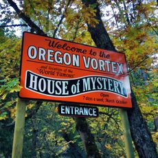
The community of curious travelers

AroundUs brings together thousands of curated places, local tips, and hidden gems, enriched daily by 60,000 contributors worldwide.

Start exploring
Location
GPS coordinates
42.84600,-123.16200
Latest update
February 9, 2026 08:22
Around this place
Oregon Vortex
United States of America

Oregon Vortex

39.8 km
Wildlife Safari
United States of America

Wildlife Safari

39.3 km
Lost Creek Lake
United States of America

Lost Creek Lake

45.3 km
Wolf Creek Inn
United States of America

Wolf Creek Inn

25.4 km
Seven Feathers Casino Resort
United States of America

Seven Feathers Casino Resort

14.5 km
Casey State Recreation Site
United States of America

Casey State Recreation Site

43.5 km
Tiller Ranger Station
United States of America

Tiller Ranger Station

19.5 km
Grave Creek Bridge
United States of America

Grave Creek Bridge

29.3 km
Rand Ranger Station
United States of America

Rand Ranger Station

44.3 km
Whisky Creek Cabin
United States of America

Whisky Creek Cabin

43.8 km
Methodist Episcopal Church South
United States of America

Methodist Episcopal Church South

42.8 km
Floed–Lane House
United States of America

Floed–Lane House

43.4 km
Milo Academy Bridge
United States of America

Milo Academy Bridge

14.3 km
Horse Creek Bridge
United States of America

Horse Creek Bridge

22.3 km
Wimer Bridge
United States of America

Wimer Bridge

34.3 km
Neal Lane Bridge
United States of America

Neal Lane Bridge

21.1 km
Newman United Methodist Church
United States of America

Newman United Methodist Church

46.8 km
Roseburg National Guard Armory
United States of America

Roseburg National Guard Armory

42.9 km
Judge James Watson Hamilton House
United States of America

Judge James Watson Hamilton House

42.7 km
James Wimer Octagonal Barn
United States of America

James Wimer Octagonal Barn

46.4 km
Cavitt Creek Bridge
United States of America

Cavitt Creek Bridge

45.8 km
Hugo Community Baptist Church
United States of America

Hugo Community Baptist Church

35.1 km
U.S. Post Office
United States of America

U.S. Post Office

43 km
John and Susanna Ahlf House
United States of America

John and Susanna Ahlf House

46.5 km
Kohlhagen Building
United States of America

Kohlhagen Building

43 km
Douglas County Museum
United States of America

Douglas County Museum

42 km
Red Mountain Lookout
United States of America

Red Mountain Lookout

19.5 km
Robertson Bridge
United States of America

Robertson Bridge

47.2 km
Show the full map
Reviews
Share your experience

No review yet

Discussions
Start a discussion...

No discussion yet

« Galesville Reservoir - water storage reservoir in galesville » is provided by Around Us (aroundus.com). Images and texts are derived from Wikimedia project under a Creative Commons license. You are allowed to copy, distribute, and modify copies of this page, under the conditions set by the license, as long as this note is clearly visible.

Discover hidden gems everywhere you go!

From secret cafés to breathtaking viewpoints, skip the crowded tourist spots and find places that match your style. Our app makes it easy with voice search, smart filtering, route optimization, and insider tips from travelers worldwide. Download now for the complete mobile experience.

Around Us App Screenshot

A unique approach to discovering new places

Le Figaro

All the places worth exploring

France Info

A tailor-made excursion in just a few clicks

20 Minutes

Around Us
Travel Guide & Maps
Download

Send to your phone

QR Code
1

Open the camera app on your mobile.

2

Point at the QR code with your camera. A notification will appear.

3

Tap the notification to open the link.