Enable Location

We need your location to show you interesting places around you

Discover nearby places

Find interesting locations and hidden gems around you

Precise directions

Get accurate directions and distances to places

Your location is never shared with other users. It's only used when you tap the location button.

Redman Hirahara Farmstead

Log in to your account

Start exploring — it's free

Trusted by 61,362 travelers worldwide

Continue with Google
Continue with Apple
or

We will send you a code to connect

By continuing, you accept our Terms and Conditions and our Privacy Policy

Check your inbox

We've sent a pincode in your inbox. Please enter the code below.

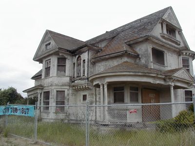
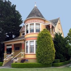
Redman Hirahara Farmstead, Historic farmstead in Watsonville, United States

Description

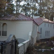
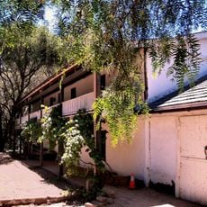
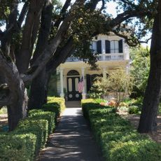
The Redman Hirahara Farmstead is a Victorian farmhouse situated on around 14 acres of agricultural land along Highway 1 in California's Pajaro Valley, featuring oak and maple interior finishes. The property is currently used for organic crop production, while preservation efforts work to maintain the historical structures.

History

The farmstead was built in 1897 by architect William H. Weeks for James Redman, and was later purchased by the Hirahara family in the 1930s. This change of ownership connected the property to the Japanese-American history of the region.

Culture

The farmstead provided shelter to Japanese families who returned from internment camps after World War II, helping them rebuild their lives in the community. This role made the place a symbol of support during a difficult period in local history.

Practical

The property sits along Highway 1, making it easy to locate, though much of it remains on active farmland that is not freely accessible to visitors. The site's historical significance is best appreciated from the road or through organized tours if available.

Did you know?

During World War II internment, local citizens including attorney John McCarthy protected the Hirahara family's property rights, allowing them to retain ownership during their absence. This neighborhood support was uncommon and proved crucial to the family's ability to return and rebuild.

Location
Inception
1897
Address
1635 West Beach Drive
GPS coordinates
36.89639,-121.77583
Latest update
December 7, 2025 20:46

AroundUs brings together thousands of curated places, local tips, and hidden gems, enriched daily by 60,000 contributors worldwide. Discover all places nearby (Watsonville).

Around this place
Gilroy Gardens
United States of America

Gilroy Gardens

17.9 km
The Forest of Nisene Marks State Park
United States of America

The Forest of Nisene Marks State Park

19.1 km
Seacliff State Beach
United States of America

Seacliff State Beach

14.9 km
Uvas Canyon County Park
United States of America

Uvas Canyon County Park

20.5 km
New Brighton State Beach
United States of America

New Brighton State Beach

16.3 km
Manresa State Beach
United States of America

Manresa State Beach

8.5 km
Rispin Mansion
United States of America

Rispin Mansion

18.5 km
Castro Adobe
United States of America

Castro Adobe

6.4 km
Moss Landing State Beach
United States of America

Moss Landing State Beach

9.3 km
Salinas River State Beach
United States of America

Salinas River State Beach

12.7 km
Santa Cruz Breakwater Light
United States of America

Santa Cruz Breakwater Light

21.4 km
Salinas River National Wildlife Refuge
United States of America

Salinas River National Wildlife Refuge

17.4 km
Ellicott Slough National Wildlife Refuge
United States of America

Ellicott Slough National Wildlife Refuge

6.6 km
Venetian Court
United States of America

Venetian Court

17.9 km
Pleasure Point roadhouse
United States of America

Pleasure Point roadhouse

18.4 km
Frank Norris Cabin
United States of America

Frank Norris Cabin

16.6 km
Godfrey M. Bockius House
United States of America

Godfrey M. Bockius House

3.3 km
Castroville Japanese Language School
United States of America

Castroville Japanese Language School

14.8 km
Giant artichoke
United States of America

Giant artichoke

15 km
Porter-Vallejo Mansion
United States of America

Porter-Vallejo Mansion

2.5 km
Judge Lee House
United States of America

Judge Lee House

2.6 km
Hihn Building
United States of America

Hihn Building

17.6 km
Marentis House
United States of America

Marentis House

21.6 km
Centro Hortícola y Jardín Botánico de Cabrillo College
United States of America

Centro Hortícola y Jardín Botánico de Cabrillo College

15.1 km
Santa Cruz Boardroom
United States of America

Santa Cruz Boardroom

18.4 km
Sunset Beach
United States of America

Sunset Beach

5.2 km
Lettunich Building
United States of America

Lettunich Building

2.3 km
Highway 152 Tree Row
United States of America

Highway 152 Tree Row

19.4 km
Show the full map
« Redman Hirahara Farmstead - Historic farmstead in Watsonville, United States » is provided by Around Us (aroundus.com). Images and texts are derived from Wikimedia project under a Creative Commons license. You are allowed to copy, distribute, and modify copies of this page, under the conditions set by the license, as long as this note is clearly visible.

Discover hidden gems everywhere you go!

From secret cafés to breathtaking viewpoints, skip the crowded tourist spots and find places that match your style. Our app makes it easy with voice search, smart filtering, route optimization, and insider tips from travelers worldwide. Download now for the complete mobile experience.

Around Us App Screenshot

A unique approach to discovering new places

Le Figaro

All the places worth exploring

France Info

A tailor-made excursion in just a few clicks

20 Minutes

Around Us
Travel Guide & Maps
Download

Send to your phone

QR Code
1

Open the camera app on your mobile.

2

Point at the QR code with your camera. A notification will appear.

3

Tap the notification to open the link.