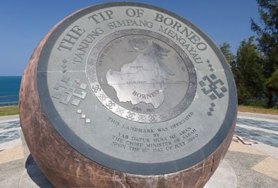
Tanjung Simpang Mengayau, Historic cape at northern tip of Borneo, Kudat, Malaysia.
Tanjung Simpang Mengayau is a historic cape marking the northern extremity of Borneo, where the South China Sea and Sulu Sea meet and create a distinctive junction point. The headland features coastal rock formations and a shoreline shaped by the meeting of these two maritime zones.
During the Song, Ming, and Qing dynasties, merchant ships encountered treacherous conditions near this cape, with many vessels wrecking on the rocks. These incidents made the location a notorious hazard along ancient trade routes across Asian waters.
The name comes from the Rungus language and recalls how indigenous people defended their coastline against pirate attacks over centuries. This linguistic heritage reflects the deep bond between the local communities and the surrounding waters.
The site lies roughly 215 kilometers from Kota Kinabalu via paved roads with gravel sections, and the journey takes about three hours by vehicle. Visitors should be prepared for the long drive and check local weather conditions before making the trip.
A large bronze globe marks the geographic coordinates of this location and features historical inscriptions on its reverse side depicting the island of Borneo. This monument serves as a visible landmark that visitors encounter upon arrival at the headland.
The community of curious travelers
AroundUs brings together thousands of curated places, local tips, and hidden gems, enriched daily by 60,000 contributors worldwide.