Fray Bentos

Log in to your account

AroundUs is a community-driven map of interesting places, built by curious explorers like you. It grows with every review, story, and photo you share.
Connect to save your favorite spots, contribute locations, and create personalized routes.
Continue with Google
Continue with Apple
Continue with X
Continue with Facebook
Continue with email
By continuing, you accept our Terms and Conditions and our Privacy Policy
Create an account

Fray Bentos

Add to collection
Map
Suggest a change
Share

Fray Bentos, Industrial heritage site in Rio Negro Department, Uruguay.

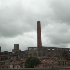
Fray Bentos is an industrial city on the Uruguay River in Río Negro Department where a large former meat processing plant still stands with its brick buildings, tall chimney, and factory structures fully preserved. The factory complex spreads across a significant area and shows the rooms where meat was processed and packaged for export.

The plant opened in 1863 and made the city a major global supplier of processed meat products for more than a century. This long period of production shaped the city fundamentally and attracted workers from many countries who came to work there.

The workers who came to this city from around the world left their mark on local life, traditions, and the way the community developed over generations. You can still see this international heritage reflected in the neighborhoods and social spaces built near the factory.

The former factory is accessible as a museum where guided tours in multiple languages take visitors through machinery rooms and production areas. It is helpful to allow enough time to explore the different levels and spaces at a comfortable pace.

The factory's cold storage building retains its original marble floors and original equipment that shows how meat was processed from slaughter through packaging and storage. These rooms document the technical methods from the 1800s that were considered advanced technology at that time.

Location: Río Negro Department

Inception: April 16, 1859

Elevation above the sea: 23 m

GPS coordinates: -33.11652,-58.31310

Latest update: December 14, 2025 19:06

Photos
Around this place
San José palace
Argentina

San José palace

79.2 km
Frigorífico Anglo del Uruguay
Uruguay

Frigorífico Anglo del Uruguay

2.2 km
Palmar Dam
Uruguay

Palmar Dam

80.7 km
Colegio del Uruguay
Argentina

Colegio del Uruguay

70.8 km
Agraciada Beach
Uruguay

Agraciada Beach

77.7 km
Parque Nacional de los Esteros de Farrapos e Islas del Río Uruguay
Uruguay

Parque Nacional de los Esteros de Farrapos e Islas del Río Uruguay

46.1 km
Gualeguaychú Sambadrome
Argentina

Gualeguaychú Sambadrome

22.2 km
Monumento a Perpetuidad, Paysandú
Uruguay

Monumento a Perpetuidad, Paysandú

90.8 km
Teatro Florencio Sánchez
Uruguay

Teatro Florencio Sánchez

91.5 km
St. Joseph's Cathedral, Gualeguaychú
Argentina

St. Joseph's Cathedral, Gualeguaychú

22.1 km
Reserva forestal Chaviyú
Argentina

Reserva forestal Chaviyú

73.2 km
National Technological University – Concepción del Uruguay Regional Faculty
Argentina

National Technological University – Concepción del Uruguay Regional Faculty

69.6 km
Museo Luis Alberto Solari
Uruguay

Museo Luis Alberto Solari

63 m
Gualeguaychú train station
Argentina

Gualeguaychú train station

22.1 km
Stella Maris Lighthouse
Argentina

Stella Maris Lighthouse

72.2 km
Centro de Documentación e Investigación Daniel Vidart
Uruguay

Centro de Documentación e Investigación Daniel Vidart

91.4 km
San Isidro Golf & Yacht Club
Uruguay

San Isidro Golf & Yacht Club

31.6 km
Centro de detención del Batallón de Infantería No. 9
Uruguay

Centro de detención del Batallón de Infantería No. 9

177 m
Basilica of Our Lady of the Rosary and Saint Benedict of Palermo
Uruguay

Basilica of Our Lady of the Rosary and Saint Benedict of Palermo

91.6 km
Biblioteca Popular El porvenir
Argentina

Biblioteca Popular El porvenir

70.6 km
Monumento al Himno Nacional
Uruguay

Monumento al Himno Nacional

90.9 km
Plaza Ramírez
Argentina

Plaza Ramírez

79.2 km
Jefatura de policía de Paysandu
Uruguay

Jefatura de policía de Paysandu

91.4 km
Edificio del antiguo Hospital y Asilo Pinillas. Primer hospital de caridad de las Hermanas del Huerto construido en 1883 - Actual Sede de la Casa del Espíritu de Paysandú.
Uruguay

Edificio del antiguo Hospital y Asilo Pinillas. Primer hospital de caridad de las Hermanas del Huerto construido en 1883 - Actual Sede de la Casa del Espíritu de Paysandú.

91.4 km
Casa que habito el Gral. Benjamín Victorica
Argentina

Casa que habito el Gral. Benjamín Victorica

70.9 km
Edificio de la Aduana Vieja
Argentina

Edificio de la Aduana Vieja

69.5 km
Casa del Gral. Justo José de Urquiza
Argentina

Casa del Gral. Justo José de Urquiza

70.8 km
La Vanguardia Polo & Golf
Uruguay

La Vanguardia Polo & Golf

80.8 km
Show the full map
Reviews

Visited this place? Tap the stars to rate it and share your experience / photos with the community! Try now! You can cancel it anytime.

« Fray Bentos - Industrial heritage site in Rio Negro Department, Uruguay » is provided by Around Us (aroundus.com). Images and texts are derived from Wikimedia project under a Creative Commons license. You are allowed to copy, distribute, and modify copies of this page, under the conditions set by the license, as long as this note is clearly visible.

Discover hidden gems everywhere you go!

From secret cafés to breathtaking viewpoints, skip the crowded tourist spots and find places that match your style. Our app makes it easy with voice search, smart filtering, route optimization, and insider tips from travelers worldwide. Download now for the complete mobile experience.

Around Us App Screenshot

A unique approach to discovering new places

Le Figaro

All the places worth exploring

France Info

A tailor-made excursion in just a few clicks

20 Minutes