Paso de los Libres – Uruguaiana International Bridge

Log in to your account

AroundUs is a community-driven map of interesting places, built by curious explorers like you. It grows with every review, story, and photo you share.
Connect to save your favorite spots, contribute locations, and create personalized routes.
Continue with Google
Continue with Apple
Continue with X
Continue with Facebook
Continue with email
By continuing, you accept our Terms and Conditions and our Privacy Policy
Create an account

Paso de los Libres – Uruguaiana International Bridge

Add to collection
Map
Suggest a change
Share

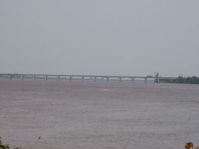
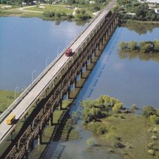
Paso de los Libres – Uruguaiana International Bridge, Combined road and railway bridge connecting Paso de los Libres, Argentina and Uruguaiana, Brazil

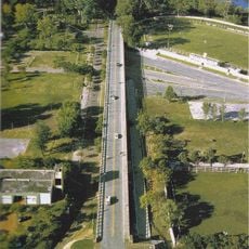
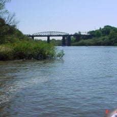
The Paso de los Libres–Uruguaiana International Bridge is a combined road and railway crossing spanning 1,419 meters (4,655 feet) above the Uruguay River, linking Paso de los Libres in Argentina with Uruguaiana in Brazil. The structure features separate lanes for vehicles and trains, allowing both forms of traffic to operate side by side safely.

Construction of this international connection began in 1942 during World War II and was completed on October 15, 1945. The project marked a turning point in regional infrastructure, enabling direct transportation links between Argentina and Brazil.

The bridge carries the names of two national leaders—Agustín P. Justo from Argentina and Getúlio Vargas from Brazil—reflecting the political partnership between the nations. As you cross, you encounter these names as a reminder of the shared history binding the two countries.

The structure serves as a border crossing and operates daily with international cargo trucks, passenger vehicles, and railway transport. When crossing, allow extra time for processing, especially during peak hours and holidays.

The bridge employs a cantilever design that supports the roadways above the wide river without driving pilings into the water. This engineering solution was remarkable for its time and remains a noteworthy feat of structural design.

Inception: October 15, 1945

Official opening: October 15, 1945

Part of: Argentina–Brazil border

GPS coordinates: -29.74306,-57.09306

Latest update: December 8, 2025 20:02

Photos
Reviews

Visited this place? Tap the stars to rate it and share your experience / photos with the community! Try now! You can cancel it anytime.

« Paso de los Libres – Uruguaiana International Bridge - Combined road and railway bridge connecting Paso de los Libres, Argentina and Uruguaiana, Brazil » is provided by Around Us (aroundus.com). Images and texts are derived from Wikimedia project under a Creative Commons license. You are allowed to copy, distribute, and modify copies of this page, under the conditions set by the license, as long as this note is clearly visible.

Discover hidden gems everywhere you go!

From secret cafés to breathtaking viewpoints, skip the crowded tourist spots and find places that match your style. Our app makes it easy with voice search, smart filtering, route optimization, and insider tips from travelers worldwide. Download now for the complete mobile experience.

Around Us App Screenshot

A unique approach to discovering new places

Le Figaro

All the places worth exploring

France Info

A tailor-made excursion in just a few clicks

20 Minutes