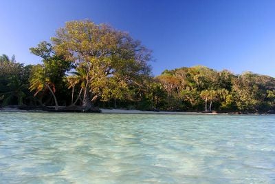
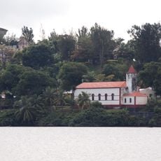
Île aux Nattes, Tropical island south of Île Sainte-Marie, Madagascar
Île aux Nattes is a small tropical island south of Île Sainte-Marie featuring white sand beaches and shallow coral reefs visible from the shore. The island covers less than 5 square kilometers and is dotted with fishing villages that sit mostly on the southern side.
The island was settled by maritime communities that established themselves along Madagascar's eastern coast centuries ago. Fishing has remained the foundation of life ever since that early settlement.
Fishing traditions shape daily life on the island, with residents working the waters as their families have for generations. You will see wooden pirogues dotted along the shoreline, handmade using methods passed down through families.
The island is reachable by pirogue in about 10 minutes from the southern tip of Île Sainte-Marie and is accessible year-round. Arranging boat transport with locals beforehand helps ensure smooth passage to the island.
The beaches here serve as important nesting grounds for several sea turtle species, making conservation efforts a priority on the island. This role in marine protection makes it a valuable site for understanding turtle breeding and survival in the Indian Ocean.
Location: Toamasina Province
GPS coordinates: -17.10944,49.80672
Latest update: December 6, 2025 17:43
Madagascar features natural landscapes ranging from the baobab avenues near Morondava to the limestone formations of the Tsingy and coastal areas with coral reefs. The country's national parks protect tropical rainforests inhabited by lemurs, along with geological features including crater lakes and...
Rova of Antananarivo
314.2 km
Ambohimanga
300.8 km
Marojejy National Park
295.1 km
Masoala National Park
167.4 km
Mahamasina Municipal Stadium
314.5 km
Rainforests of the Atsinanana
295.2 km
Ambohitsorohitra Palace
314 km
Zahamena National Park
122.7 km
Peyrieras Reptile Reserve
293.4 km
Andafiavaratra Palace
314 km
Botanical and Zoological Garden of Tsimbazaza
315.2 km
Immaculate Conception Cathedral, Antananarivo
314 km
Zoma
313.7 km
Lycée Andohalo Antananarivo
314 km
Leuchtturm l'île aux Prunes
110.9 km
Saint Laurent's Cathedral, Ambohimanoro
313.8 km
FJKM Rasalama Maritiora Ambohipotsy
314.8 km
Betsiboka Bridge
304.7 km
EKAR Faravohitra
313.2 km
Humbert Falls
299.8 km
Croc Farm Ivato
310.4 km
Temple FJKM de Faravohitra
313.4 km
Pont de la Kamoro
290.3 km
Tranompokonolona Analakely
313.6 km
Lemur Island
245.9 km
Saint Mary, Ambodifototra
12.4 km
Pirates Cemetery
11.7 km
Ville haute d'Antananarivo
314.1 kmVisited this place? Tap the stars to rate it and share your experience / photos with the community! Try now! You can cancel it anytime.
Discover hidden gems everywhere you go!
From secret cafés to breathtaking viewpoints, skip the crowded tourist spots and find places that match your style. Our app makes it easy with voice search, smart filtering, route optimization, and insider tips from travelers worldwide. Download now for the complete mobile experience.
A unique approach to discovering new places❞
— Le Figaro
All the places worth exploring❞
— France Info
A tailor-made excursion in just a few clicks❞
— 20 Minutes