Chest opened
+${chestReward.xp} XP
Explorer
NOUVEAU ×${chestReward.collectible.quantity}
tapez pour fermer
Chest locked

Open chests in the app

Around Us is built for your phone — chests unlock when you walk, explore and capture nearby places.

Enable Location

We need your location to show you interesting places around you

Discover nearby places

Find interesting locations and hidden gems around you

Precise directions

Get accurate directions and distances to places

Your location is never shared with other users. It's only used when you tap the location button.

King Salmon

Log in to your account

Start exploring — it's free

Trusted by 72,890 travelers worldwide

Continue with Google
Continue with Apple
or

We will send you a code to connect

By continuing, you accept our Terms and Conditions and our Privacy Policy

Check your inbox

We've sent a pincode in your inbox. Please enter the code below.

Discussion Reviews 1 Photos
26.1k Popularity

King Salmon, Census-designated place in Bristol Bay Borough and Lake and Peninsula Borough, Alaska.

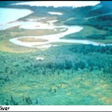
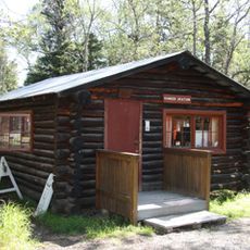
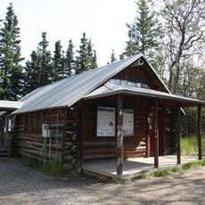
King Salmon is a small community in Alaska situated near the Naknek River, functioning as a gateway to Katmai National Park and Preserve. The settlement provides essential services and is positioned at a key point for exploring the surrounding wild landscapes.

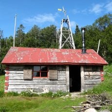
The settlement was established in 1930 alongside the construction of the Naknek Air Force Base, a military facility that was later converted into the current airport. This aviation infrastructure remained central to the community after the military era ended.

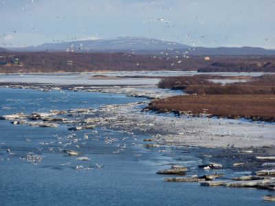
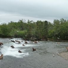
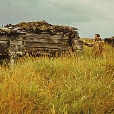
The community's identity is rooted in salmon fishing, which shapes how people work and spend their time here. This tradition remains central to the local way of life.

King Salmon Airport is the main way to reach the area, and ground transportation and rental vehicles are available there. Sturdy footwear and weather-resistant clothing are essential, as conditions change quickly and the surroundings are often damp and windy.

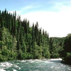
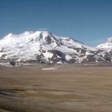
The location sits at the edge of a habitat where wild bears and large salmon runs move seasonally between river and ocean. This untamed nature is visible right outside the community and shapes its character.

The community of curious travelers

AroundUs brings together thousands of curated places, local tips, and hidden gems, enriched daily by 60,000 contributors worldwide.

Start exploring
Inception
1930s
Elevation above the sea
21 m
GPS coordinates
58.68604,-156.65508
Latest update
December 25, 2025 07:59
Around this place
Novarupta
United States of America

Novarupta

98.9 km
Katmai National Park and Preserve
United States of America

Katmai National Park and Preserve

98.2 km
Brooks Falls
United States of America

Brooks Falls

52.1 km
Fure's Cabin
United States of America

Fure's Cabin

71.1 km
Alagnak River
United States of America

Alagnak River

80.8 km
Mount Griggs
United States of America

Mount Griggs

97.4 km
Trident Volcano
United States of America

Trident Volcano

103.4 km
Becharof National Wildlife Refuge
United States of America

Becharof National Wildlife Refuge

80 km
Mount Martin
United States of America

Mount Martin

95.1 km
Mount Mageik
United States of America

Mount Mageik

98.3 km
Old Savonoski Site
United States of America

Old Savonoski Site

83.6 km
Brooks River Archeological District
United States of America

Brooks River Archeological District

52.8 km
Elevation of Holy Cross Church
United States of America

Elevation of Holy Cross Church

20.4 km
Brooks Camp Boat House
United States of America

Brooks Camp Boat House

52.9 km
Brooks River Historic Ranger Station
United States of America

Brooks River Historic Ranger Station

52.9 km
St. John the Baptist Chapel
United States of America

St. John the Baptist Chapel

21 km
United States of America

Savonoski River Archeological District

95.4 km
Brooks Camp Visitor Center
United States of America

Brooks Camp Visitor Center

52.8 km
Falling Mountain
United States of America

Falling Mountain

103.4 km
United States of America

Middle Bluff

59.2 km
United States of America

Alagnak Wild River

48.3 km
United States of America

Battle Lake

109.1 km
United States of America

Kulik Lake

101.9 km
United States of America

Mount Martin

95 km
United States of America

Prehistoric Alutiiq Pit House

52.5 km
United States of America

Scenic viewpoint

75.8 km
United States of America

Scenic viewpoint

66.8 km
United States of America

Scenic viewpoint

51.5 km
Show the full map
Reviews
Share your experience

No review yet

Discussions
Start a discussion...

No discussion yet

« King Salmon - Census-designated place in Bristol Bay Borough and Lake and Peninsula Borough, Alaska » is provided by Around Us (aroundus.com). Images and texts are derived from Wikimedia project under a Creative Commons license. You are allowed to copy, distribute, and modify copies of this page, under the conditions set by the license, as long as this note is clearly visible.

Discover hidden gems everywhere you go!

From secret cafés to breathtaking viewpoints, skip the crowded tourist spots and find places that match your style. Our app makes it easy with voice search, smart filtering, route optimization, and insider tips from travelers worldwide. Download now for the complete mobile experience.

Around Us App Screenshot

A unique approach to discovering new places

Le Figaro

All the places worth exploring

France Info

A tailor-made excursion in just a few clicks

20 Minutes

Around Us
Travel Guide & Maps
Download

Send to your phone

QR Code
1

Open the camera app on your mobile.

2

Point at the QR code with your camera. A notification will appear.

3

Tap the notification to open the link.