Enable Location

We need your location to show you interesting places around you

Discover nearby places

Find interesting locations and hidden gems around you

Precise directions

Get accurate directions and distances to places

Your location is never shared with other users. It's only used when you tap the location button.

Slaven's Cabin

Log in to your account

Start exploring — it's free

Trusted by 61,365 travelers worldwide

Continue with Google
Continue with Apple
or

We will send you a code to connect

By continuing, you accept our Terms and Conditions and our Privacy Policy

Check your inbox

We've sent a pincode in your inbox. Please enter the code below.

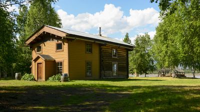
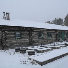
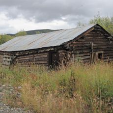
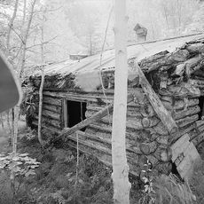
Slaven's Cabin, Historic roadhouse in Yukon-Charley Rivers National Preserve, Alaska

Description

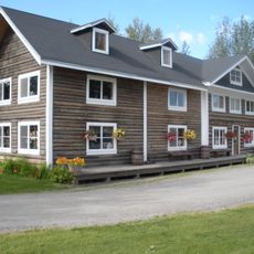
Slaven's Cabin is a two-story spruce log structure built with a compact footprint and vertical walls that support its upper level. A covered overhang on the south side provides additional space and weather protection for those seeking shelter.

History

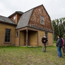
Frank Slaven built this cabin in 1932 to serve as a resting point along the Yukon River for people traveling through the region. It remained an active stop for miners and travelers until around the 1950s.

Culture

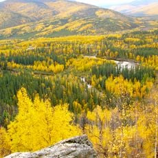
The cabin reflects how early 20th-century travelers and workers depended on river routes to move through remote Alaska. Visitors can sense how people gathered at such stops to rest, trade information, and connect with others passing through.

Practical

The restored building serves today as a public facility within the preserve where visitors can stop and orient themselves. Access comes from the main route through the area, and the location provides a good stopping point for those exploring the surrounding mining district.

Did you know?

The cabin serves as an official checkpoint for the Yukon Quest International Sled Dog Race, a long-distance winter competition across remote Alaska. During the race, the location becomes a vital meeting point for mushers and their support teams navigating one of North America's toughest endurance events.

Location
Architectural style
rustic architecture
GPS coordinates
65.35056,-143.12000
Latest update
December 14, 2025 16:45

AroundUs brings together thousands of curated places, local tips, and hidden gems, enriched daily by 60,000 contributors worldwide. Discover all places nearby (Alaska).

Around this place
Trans-Alaska Pipeline System
United States of America

Trans-Alaska Pipeline System

185.5 km
Bluefish Caves
Canada

Bluefish Caves

183.2 km
Fairbanks Gold Rush
United States of America

Fairbanks Gold Rush

207.5 km
Goldstream Dredge No. 8
United States of America

Goldstream Dredge No. 8

217 km
Yukon Flats National Wildlife Refuge
United States of America

Yukon Flats National Wildlife Refuge

170.8 km
White Mountains National Recreation Area
United States of America

White Mountains National Recreation Area

217.9 km
Rika's Landing Roadhouse
United States of America

Rika's Landing Roadhouse

185.4 km
Chena River State Recreation Area
United States of America

Chena River State Recreation Area

157.9 km
Creamer's Field Migratory Waterfowl Refuge
United States of America

Creamer's Field Migratory Waterfowl Refuge

222.6 km
Fort Egbert
United States of America

Fort Egbert

109.1 km
Lacey Street Theatre
United States of America

Lacey Street Theatre

222.6 km
Coal Creek Historic Mining District
United States of America

Coal Creek Historic Mining District

5.8 km
Biederman's Cabin
United States of America

Biederman's Cabin

27.2 km
Discovery Claim on Pedro Creek
United States of America

Discovery Claim on Pedro Creek

208 km
Kandik River
United States of America

Kandik River

82.1 km
Fairbanks Exploration Company Housing
United States of America

Fairbanks Exploration Company Housing

222.5 km
Sullivan Roadhouse
United States of America

Sullivan Roadhouse

192 km
Fairbanks Exploration Company Machine Shop
United States of America

Fairbanks Exploration Company Machine Shop

222.7 km
Fairbanks Exploration Company Manager's House
United States of America

Fairbanks Exploration Company Manager's House

222.3 km
Steele Creek Roadhouse
United States of America

Steele Creek Roadhouse

148.4 km
Illinois Street Historic District
United States of America

Illinois Street Historic District

222.6 km
Chicken Historic District
United States of America

Chicken Historic District

152.8 km
George McGregor Cabin
United States of America

George McGregor Cabin

331 m
Johnson River
United States of America

Johnson River

205.9 km
Angel Rocks Trail
United States of America

Angel Rocks Trail

149.5 km
Eagle Historic District
United States of America

Eagle Historic District

109.4 km
Tanana Pipeline Bridge
United States of America

Tanana Pipeline Bridge

185.5 km
Tanana River Bridge
United States of America

Tanana River Bridge

185.6 km
Show the full map
« Slaven's Cabin - Historic roadhouse in Yukon-Charley Rivers National Preserve, Alaska » is provided by Around Us (aroundus.com). Images and texts are derived from Wikimedia project under a Creative Commons license. You are allowed to copy, distribute, and modify copies of this page, under the conditions set by the license, as long as this note is clearly visible.

Discover hidden gems everywhere you go!

From secret cafés to breathtaking viewpoints, skip the crowded tourist spots and find places that match your style. Our app makes it easy with voice search, smart filtering, route optimization, and insider tips from travelers worldwide. Download now for the complete mobile experience.

Around Us App Screenshot

A unique approach to discovering new places

Le Figaro

All the places worth exploring

France Info

A tailor-made excursion in just a few clicks

20 Minutes

Around Us
Travel Guide & Maps
Download

Send to your phone

QR Code
1

Open the camera app on your mobile.

2

Point at the QR code with your camera. A notification will appear.

3

Tap the notification to open the link.