Oxnard State Beach

Log in to your account

AroundUs is a community-driven map of interesting places, built by curious explorers like you. It grows with every review, story, and photo you share.
Connect to save your favorite spots, contribute locations, and create personalized routes.
Continue with Google
Continue with Apple
Continue with X
Continue with Facebook
Continue with email
By continuing, you accept our Terms and Conditions and our Privacy Policy
Create an account
Add to collection
Map
Suggest a change
Share

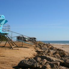
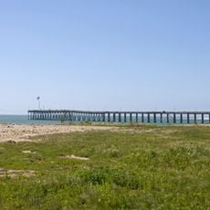
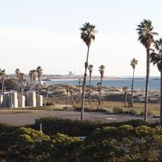
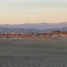
Oxnard State Beach, State beach in Oxnard, United States.

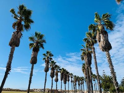
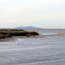
Oxnard State Beach is a sandy shoreline along the California coast featuring dunes and wetland areas that border the Pacific Ocean. The landscape extends toward the Channel Islands visible across the water.

The Chumash people, the original inhabitants of this region, called this area Ololkoy, reflecting its role as a natural sandy gathering place. This name preserves the memory of the original significance of the coastal landscape.

The beach serves as a gathering place where locals celebrate their connection to the ocean through seasonal events and community activities. These occasions reflect how residents view the coast as central to their regional identity.

Multiple parking areas are located near 5th Street and Harbor Boulevard, offering space for vehicles and beach equipment. Arriving early in the day helps ensure parking availability.

The beach contains nesting areas protected for Least Terns and Snowy Plovers, two species that depend on the sandy ground for breeding. Visitors may spot these birds during nesting season if they walk carefully along the shore.

Location: California

Address: Oxnard State Beach Park, California, USA

Website: https://visitoxnard.com/directory/oxnard-beach-park

GPS coordinates: 34.18280,-119.24000

Latest update: December 12, 2025 08:00

Photos
Around this place
Mission San Buenaventura
United States of America

Mission San Buenaventura

12.2 km
Emma Wood State Beach
United States of America

Emma Wood State Beach

13.9 km
Mullin Automotive Museum
United States of America

Mullin Automotive Museum

7 km
Ventura Pier
United States of America

Ventura Pier

11.3 km
Camarillo Ranch House
United States of America

Camarillo Ranch House

20.9 km
Henry Levy House
United States of America

Henry Levy House

5.3 km
San Buenaventura State Beach
United States of America

San Buenaventura State Beach

10.1 km
McGrath State Beach
United States of America

McGrath State Beach

5 km
Majestic Ventura Theatre
United States of America

Majestic Ventura Theatre

11.9 km
Mandalay State Beach
United States of America

Mandalay State Beach

2.1 km
Ventura County Courthouse
United States of America

Ventura County Courthouse

12.1 km
Statues of Junípero Serra
United States of America

Statues of Junípero Serra

12.1 km
Elizabeth Bard Memorial Hospital
United States of America

Elizabeth Bard Memorial Hospital

11.9 km
Foster Park Bowl
United States of America

Foster Park Bowl

20 km
Point Hueneme Light
United States of America

Point Hueneme Light

5 km
San Buenaventura Mission Aqueduct
United States of America

San Buenaventura Mission Aqueduct

18.3 km
Henry T. Oxnard Historic District
United States of America

Henry T. Oxnard Historic District

5.3 km
Golf 'N' Stuff
United States of America

Golf 'N' Stuff

8.5 km
First Baptist Church of Ventura
United States of America

First Baptist Church of Ventura

11.5 km
George Washington Faulkner House
United States of America

George Washington Faulkner House

20.2 km
Dudley House
United States of America

Dudley House

10.4 km
Feraud General Merchandise Store
United States of America

Feraud General Merchandise Store

12.2 km
San Miguel Chapel Site
United States of America

San Miguel Chapel Site

11.8 km
Peirano Market
United States of America

Peirano Market

12.1 km
Berylwood
United States of America

Berylwood

4.8 km
Emmanuel Franz House
United States of America

Emmanuel Franz House

12 km
Carnegie Art Museum
United States of America

Carnegie Art Museum

5.7 km
Women's Improvement Club of Hueneme
United States of America

Women's Improvement Club of Hueneme

5.4 km
Show the full map
Reviews

Visited this place? Tap the stars to rate it and share your experience / photos with the community! Try now! You can cancel it anytime.

« Oxnard State Beach - State beach in Oxnard, United States » is provided by Around Us (aroundus.com). Images and texts are derived from Wikimedia project under a Creative Commons license. You are allowed to copy, distribute, and modify copies of this page, under the conditions set by the license, as long as this note is clearly visible.

Discover hidden gems everywhere you go!

From secret cafés to breathtaking viewpoints, skip the crowded tourist spots and find places that match your style. Our app makes it easy with voice search, smart filtering, route optimization, and insider tips from travelers worldwide. Download now for the complete mobile experience.

Around Us App Screenshot

A unique approach to discovering new places

Le Figaro

All the places worth exploring

France Info

A tailor-made excursion in just a few clicks

20 Minutes