Enable Location

We need your location to show you interesting places around you

Discover nearby places

Find interesting locations and hidden gems around you

Precise directions

Get accurate directions and distances to places

Your location is never shared with other users. It's only used when you tap the location button.

Devils Peak

Log in to your account

Start exploring — it's free

Trusted by 61,367 travelers worldwide

Continue with Google
Continue with Apple
or

We will send you a code to connect

By continuing, you accept our Terms and Conditions and our Privacy Policy

Check your inbox

We've sent a pincode in your inbox. Please enter the code below.

Devils Peak

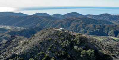
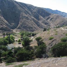
Devils Peak, Mountain summit in Channel Islands, United States.

Description

Devils Peak is a mountain summit on Santa Rosa Island in the Channel Islands that rises steeply from the ocean. The rocky formations display sharp angles and dark coloring that make the peak recognizable from the surrounding waters.

History

The summit served sailors as a navigation marker starting in the early 19th century when ships regularly passed between the islands. The recognizable shape made it valuable for maritime travelers to chart their courses through this area.

Culture

Local Native American tribes considered Devils Peak a sacred site for celestial observations and seasonal ceremonial gatherings throughout generations.

Practical

Access is difficult and requires careful planning for safety and environmental protection on this protected island. Visitors need to check conditions and any restrictions before attempting to visit the area.

Did you know?

The summit provides simultaneous views of five different Channel Islands during clear weather conditions, making it a significant geographical reference point.

Location
Part of
Channel Islands of California
GPS coordinates
34.02916,-119.78439
Latest update
December 10, 2025 20:02

AroundUs brings together thousands of curated places, local tips, and hidden gems, enriched daily by 60,000 contributors worldwide. Discover all places nearby (California).

Around this place
United States of America

Offshore oil and gas in California

41.7 km
Moreton Bay Fig Tree
United States of America

Moreton Bay Fig Tree

43.6 km
Stearns Wharf
United States of America

Stearns Wharf

43.4 km
Harder Stadium
United States of America

Harder Stadium

44 km
UC Santa Barbara Events Center
United States of America

UC Santa Barbara Events Center

43.3 km
Arroyo Burro Beach
United States of America

Arroyo Burro Beach

41.8 km
SS Winfield Scott
United States of America

SS Winfield Scott

37 km
Storke Tower
United States of America

Storke Tower

43.1 km
Douglas Family Preserve
United States of America

Douglas Family Preserve

41.5 km
Casa de la Guerra
United States of America

Casa de la Guerra

44.2 km
Goleta Beach
United States of America

Goleta Beach

43.2 km
Anacapa Island Light
United States of America

Anacapa Island Light

39.3 km
Leadbetter Beach
United States of America

Leadbetter Beach

42.3 km
Santa Barbara Museum of Natural History Sea Center
United States of America

Santa Barbara Museum of Natural History Sea Center

43.4 km
East Beach
United States of America

East Beach

43.9 km
East Beach
United States of America

East Beach

43.9 km
Paseo Nuevo
United States of America

Paseo Nuevo

43.9 km
Arlington Theatre
United States of America

Arlington Theatre

44 km
Casa Dolores
United States of America

Casa Dolores

44 km
Santa Barbara Light
United States of America

Santa Barbara Light

41.3 km
Art, Design & Architecture Museum
United States of America

Art, Design & Architecture Museum

43 km
Bren Hall
United States of America

Bren Hall

43 km
Allan Herschell 3-Abreast Carousel
United States of America

Allan Herschell 3-Abreast Carousel

43.9 km
The Wolf Museum of Exploration and Innovation
United States of America

The Wolf Museum of Exploration and Innovation

43.6 km
Paseo de la Guerra
United States of America

Paseo de la Guerra

44.2 km
Santa Barbara Maritime Museum
United States of America

Santa Barbara Maritime Museum

42.5 km
Santa Cruz Island Scorpion Ranch Campground
United States of America

Santa Cruz Island Scorpion Ranch Campground

20.7 km
Santa Rosa Island Campground
United States of America

Santa Rosa Island Campground

24.7 km
Show the full map
« Devils Peak - Mountain summit in Channel Islands, United States » is provided by Around Us (aroundus.com). Images and texts are derived from Wikimedia project under a Creative Commons license. You are allowed to copy, distribute, and modify copies of this page, under the conditions set by the license, as long as this note is clearly visible.

Discover hidden gems everywhere you go!

From secret cafés to breathtaking viewpoints, skip the crowded tourist spots and find places that match your style. Our app makes it easy with voice search, smart filtering, route optimization, and insider tips from travelers worldwide. Download now for the complete mobile experience.

Around Us App Screenshot

A unique approach to discovering new places

Le Figaro

All the places worth exploring

France Info

A tailor-made excursion in just a few clicks

20 Minutes

Around Us
Travel Guide & Maps
Download

Send to your phone

QR Code
1

Open the camera app on your mobile.

2

Point at the QR code with your camera. A notification will appear.

3

Tap the notification to open the link.