California State Route 2, Mountain highway in Los Angeles County and San Bernardino County, United States
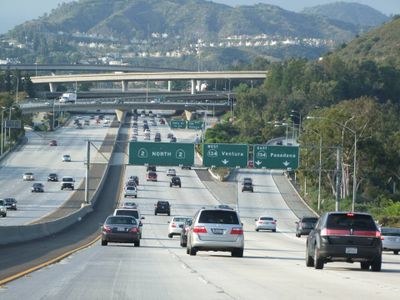
California State Route 2 is a mountain highway connecting the Los Angeles Basin with the San Gabriel Mountains and High Desert regions across 87 miles of varied terrain. The road climbs from urban foothills into alpine elevations, passing through dense forests and open ridges with different conditions at each section.
Construction began in 1929 as a fire access route through the mountains, was interrupted during World War II, and finally completed in 1956. The project relied on prison labor during its later phases to connect the lowland valleys with the high forest regions.
The road serves as the main gateway for Los Angeles residents seeking access to high-elevation wilderness and outdoor recreation. Hikers and weekenders use it regularly to reach remote trails and mountain communities that feel far removed from the city below.
The road climbs to elevations above 7,000 feet and closes seasonally between Islip Saddle and Vincent Gap when snow makes it impassable. Check conditions ahead before traveling to the upper sections, especially during late fall and winter months.
The section between La Cañada Flintridge and the Los Angeles-San Bernardino county line holds dual designation as both a National Forest Scenic Byway and a California Scenic Highway. This recognition reflects the road's visual qualities and importance for travelers seeking mountain views on their drive.
The community of curious travelers
AroundUs brings together thousands of curated places, local tips, and hidden gems, enriched daily by 60,000 contributors worldwide.