Chest opened
+${chestReward.xp} XP
Explorer
NOUVEAU ×${chestReward.collectible.quantity}
tapez pour fermer
Chest locked

Open chests in the app

Around Us is built for your phone — chests unlock when you walk, explore and capture nearby places.

Enable Location

We need your location to show you interesting places around you

Discover nearby places

Find interesting locations and hidden gems around you

Precise directions

Get accurate directions and distances to places

Your location is never shared with other users. It's only used when you tap the location button.

El Pino

Log in to your account

Start exploring — it's free

Trusted by 72,884 travelers worldwide

Continue with Google
Continue with Apple
or

We will send you a code to connect

By continuing, you accept our Terms and Conditions and our Privacy Policy

Check your inbox

We've sent a pincode in your inbox. Please enter the code below.

El Pino
Discussion Reviews 1 Photos
30.6k Popularity

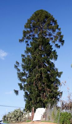
El Pino, Bunya pine landmark in Boyle Heights, Los Angeles, United States.

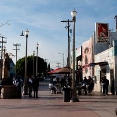
El Pino is a bunya pine tree located at the corner of Folsom Street and North Indiana Street, marking the boundary between East Los Angeles and Boyle Heights. The tree stands over 100 feet (30 meters) tall and has been a natural landmark in the area for generations.

The tree grows on land that once belonged to Dr. Okuno, a Japanese dentist who received the property after his release from World War II internment camps. The property changed hands over the decades, but the pine has remained rooted at this corner throughout.

The tree serves as a meeting place where neighbors gather to discuss neighborhood affairs and share concerns about local development. It has become a symbol of continuity for the community in a changing area.

The tree is located at a busy street corner near local shops and transit options, making it easy to reach on foot. Visitors should come during daylight hours and be aware of street traffic, as it sits at an active intersection.

The tree gained wider attention after appearing in the 1993 film Blood In Blood Out. This film appearance introduced it to many people who might not have known about it otherwise.

The community of curious travelers

AroundUs brings together thousands of curated places, local tips, and hidden gems, enriched daily by 60,000 contributors worldwide.

Start exploring
Location
Address
Folsom and N Indiana Streets
GPS coordinates
34.04325,-118.19236
Latest update
December 18, 2025 11:41
Around this place
Los Angeles County+USC Medical Center
United States of America

Los Angeles County+USC Medical Center

2.4 km
Sixth Street Viaduct
United States of America

Sixth Street Viaduct

3.2 km
Linda Vista Community Hospital
United States of America

Linda Vista Community Hospital

2.4 km
Atchison, Topeka and Santa Fe Railway 3751
United States of America

Atchison, Topeka and Santa Fe Railway 3751

4.2 km
Japanese American National Museum
United States of America

Japanese American National Museum

4.4 km
Evergreen Cemetery
United States of America

Evergreen Cemetery

806 m
Sears, Roebuck & Company Mail Order Building
United States of America

Sears, Roebuck & Company Mail Order Building

3.4 km
Lincoln Park
United States of America

Lincoln Park

2.7 km
Mariachi Plaza
United States of America

Mariachi Plaza

2.5 km
Weingart Stadium
United States of America

Weingart Stadium

3.7 km
William Mead Homes
United States of America

William Mead Homes

4.2 km
Breed Street Shul
United States of America

Breed Street Shul

1.5 km
Golden Gate Theater
United States of America

Golden Gate Theater

4.2 km
MTA Building
United States of America

MTA Building

4 km
Terminal Annex
United States of America

Terminal Annex

4.4 km
Woman's Building
United States of America

Woman's Building

4.3 km
Atomic Cafe
United States of America

Atomic Cafe

4.3 km
El Mercado de Los Angeles
United States of America

El Mercado de Los Angeles

709 m
Edward R. Roybal Federal Building and United States Courthouse
United States of America

Edward R. Roybal Federal Building and United States Courthouse

4.4 km
Boyle Hotel – Cummings Block
United States of America

Boyle Hotel – Cummings Block

2.6 km
Santa Fe Freight Depot
United States of America

Santa Fe Freight Depot

3.7 km
Lincoln Heights Branch
United States of America

Lincoln Heights Branch

4.2 km
Robert Louis Stevenson Branch
United States of America

Robert Louis Stevenson Branch

1.8 km
Malabar Branch
United States of America

Malabar Branch

959 m
Geffen Contemporary at MOCA
United States of America

Geffen Contemporary at MOCA

4.4 km
Luna Luna
United States of America

Luna Luna

3.1 km
Higashi Hongan-ji Buddhist Temple
United States of America

Higashi Hongan-ji Buddhist Temple

4.4 km
Cesar Chavez Avenue Viaduct
United States of America

Cesar Chavez Avenue Viaduct

3.5 km
Show the full map
Reviews
Share your experience

No review yet

Discussions
Start a discussion...

No discussion yet

« El Pino - Bunya pine landmark in Boyle Heights, Los Angeles, United States » is provided by Around Us (aroundus.com). Images and texts are derived from Wikimedia project under a Creative Commons license. You are allowed to copy, distribute, and modify copies of this page, under the conditions set by the license, as long as this note is clearly visible.

Discover hidden gems everywhere you go!

From secret cafés to breathtaking viewpoints, skip the crowded tourist spots and find places that match your style. Our app makes it easy with voice search, smart filtering, route optimization, and insider tips from travelers worldwide. Download now for the complete mobile experience.

Around Us App Screenshot

A unique approach to discovering new places

Le Figaro

All the places worth exploring

France Info

A tailor-made excursion in just a few clicks

20 Minutes

Around Us
Travel Guide & Maps
Download

Send to your phone

QR Code
1

Open the camera app on your mobile.

2

Point at the QR code with your camera. A notification will appear.

3

Tap the notification to open the link.