Enable Location

We need your location to show you interesting places around you

Discover nearby places

Find interesting locations and hidden gems around you

Precise directions

Get accurate directions and distances to places

Your location is never shared with other users. It's only used when you tap the location button.

Mulholland Drive

Log in to your account

Join the adventure

Create your free account and start exploring (like 60k+ others)

We will send you a code to connect

or
Continue with Google
Continue with Apple
By continuing, you accept our Terms and Conditions and our Privacy Policy

Check your inbox

We've sent a pincode in your inbox. Please enter the code below.

Mulholland Drive

Mulholland Drive, Scenic mountain road in Los Angeles County, US.

Description

Mulholland Drive is a mountain road in Los Angeles County that runs 21 miles along the crest of the Santa Monica Mountains and Hollywood Hills, linking two sections of U.S. Route 101. The route follows the natural ridgeline and offers alternating views of the city to the south and the San Fernando Valley to the north, passing through residential neighborhoods, parks, and undeveloped land.

History

Construction began in 1924 by a group of investors seeking to promote interest in property in the Hollywood Hills, under the direction of engineer William Mulholland. Over the following decades, the road was gradually extended westward, with some sections paved and others remaining as dirt trails.

Culture

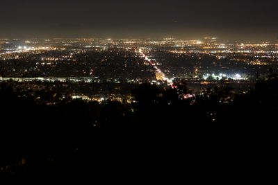
The name honors William Mulholland, the engineer who brought water to Los Angeles and made settlement in the hills possible. Today, locals use the overlooks along the route as popular meeting spots, especially at sunset or at night when the city lights up below.

Practical

Several sections of the route are unpaved and open only to pedestrians and cyclists, while cars must take detours through parallel roads. The best views are typically found in clear weather and during morning or evening hours, when the sun is low and the light illuminates the city.

Did you know?

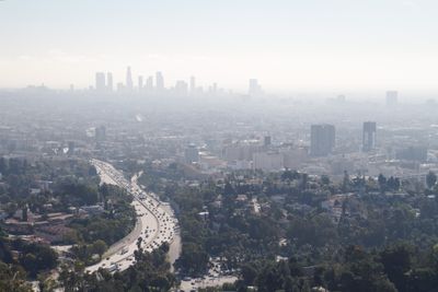
The eastern terminus near Cahuenga Boulevard offers simultaneous views of the Hollywood Sign and the downtown Los Angeles skyline. At this point, the two mountain ranges meet, and the orientation of the road shifts abruptly from east-west to north-south.

GPS coordinates
34.13130,-118.49000
Latest update
December 12, 2025 20:51

AroundUs brings together thousands of curated places, local tips, and hidden gems, enriched daily by 60,000 contributors worldwide. Discover all places nearby (Los Angeles County).

Around this place
Getty Center
United States of America

Getty Center

6.1 km
J. Paul Getty Museum
United States of America

J. Paul Getty Museum

6.2 km
Chartwell Mansion
United States of America

Chartwell Mansion

6.6 km
Harold Lloyd Estate
United States of America

Harold Lloyd Estate

7.5 km
Sheats Goldstein Residence
United States of America

Sheats Goldstein Residence

6.6 km
Murphy Ranch
United States of America

Murphy Ranch

6.9 km
Carolwood Pacific Railroad
United States of America

Carolwood Pacific Railroad

7.6 km
Sepulveda Dam
United States of America

Sepulveda Dam

4.2 km
George Sturges House
United States of America

George Sturges House

7.2 km
Bel-Air Country Club
United States of America

Bel-Air Country Club

7 km
UCLA Drake Track and Field Stadium
United States of America

UCLA Drake Track and Field Stadium

7.7 km
Beverly Hills Women's Club
United States of America

Beverly Hills Women's Club

7.5 km
Bel Air Presbyterian Church
United States of America

Bel Air Presbyterian Church

467 m
The Japanese Garden
United States of America

The Japanese Garden

5.9 km
UCLA Fowler Museum of Cultural History
United States of America

UCLA Fowler Museum of Cultural History

7.8 km
Los Encinos State Historic Park
United States of America

Los Encinos State Historic Park

3.3 km
Wallis Annenberg Stadium
United States of America

Wallis Annenberg Stadium

7.7 km
United States of America

Van Nuys City Hall

7.1 km
Franklin D. Murphy Sculpture Garden
United States of America

Franklin D. Murphy Sculpture Garden

7.8 km
Valley Beth Shalom
United States of America

Valley Beth Shalom

3 km
Cathedral of St. Mary Byzantine Catholic Church
United States of America

Cathedral of St. Mary Byzantine Catholic Church

4.6 km
Saint Saviour's Chapel
United States of America

Saint Saviour's Chapel

7.4 km
Van Nuys Branch
United States of America

Van Nuys Branch

7 km
UCLA University Residence
United States of America

UCLA University Residence

7.5 km
UCLA Broad Art Center
United States of America

UCLA Broad Art Center

7.6 km
UCLA Straus Stadium
United States of America

UCLA Straus Stadium

7.8 km
UCLA Marion Anderson Hall
United States of America

UCLA Marion Anderson Hall

7.7 km
Standing Woman
United States of America

Standing Woman

7.8 km
Show the full map
« Mulholland Drive - Scenic mountain road in Los Angeles County, US » is provided by Around Us (aroundus.com). Images and texts are derived from Wikimedia project under a Creative Commons license. You are allowed to copy, distribute, and modify copies of this page, under the conditions set by the license, as long as this note is clearly visible.

Discover hidden gems everywhere you go!

From secret cafés to breathtaking viewpoints, skip the crowded tourist spots and find places that match your style. Our app makes it easy with voice search, smart filtering, route optimization, and insider tips from travelers worldwide. Download now for the complete mobile experience.

Around Us App Screenshot

A unique approach to discovering new places

Le Figaro

All the places worth exploring

France Info

A tailor-made excursion in just a few clicks

20 Minutes

Around Us
Travel Guide & Maps
Download

Send to your phone

QR Code
1

Open the camera app on your mobile.

2

Point at the QR code with your camera. A notification will appear.

3

Tap the notification to open the link.