Enable Location

We need your location to show you interesting places around you

Discover nearby places

Find interesting locations and hidden gems around you

Precise directions

Get accurate directions and distances to places

Your location is never shared with other users. It's only used when you tap the location button.

Phoenix Air Defense Sector

Log in to your account

Join the adventure

Create your free account and start exploring (like 60k+ others)

We will send you a code to connect

or
Continue with Google
Continue with Apple
By continuing, you accept our Terms and Conditions and our Privacy Policy

Check your inbox

We've sent a pincode in your inbox. Please enter the code below.

Phoenix Air Defense Sector

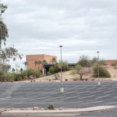
Phoenix Air Defense Sector, Military air defense installation in Luke Air Force Base, Arizona.

Description

Phoenix Air Defense Sector was a military installation at Luke Air Force Base in Arizona that coordinated aircraft and radar operations across a large area of the Southwest region. The facility managed multiple radar stations and interceptor squadrons to maintain continuous monitoring of designated airspace.

History

The installation was established in June 1959 and integrated advanced SAGE computer systems as part of Air Defense Command operations. It operated until April 1966, playing an important role in Cold War defense strategy.

Culture

The installation fostered professional development among military personnel through specialized training programs focused on radar operations and interceptor aircraft tactics.

Practical

Access to the installation is limited today since information is primarily available through military archives and historical records. Visitors interested in air defense history can search documentation and archives to learn more about its operations.

Did you know?

The facility used two AN/FSQ-7 computers, which occupied an entire floor and processed data from multiple radar stations. These computer systems were cutting-edge machines at the time, capable of analyzing massive amounts of airspace data in real time.

Location
GPS coordinates
33.54280,-112.35700
Latest update
December 12, 2025 12:05

AroundUs brings together thousands of curated places, local tips, and hidden gems, enriched daily by 60,000 contributors worldwide. Discover all places nearby (Arizona).

Around this place
State Farm Stadium
United States of America

State Farm Stadium

8.9 km
Phoenix Raceway
United States of America

Phoenix Raceway

19.2 km
Desert Sky Pavilion
United States of America

Desert Sky Pavilion

14 km
Castles N' Coasters
United States of America

Castles N' Coasters

22.3 km
White Tank Mountains
United States of America

White Tank Mountains

20.9 km
Wildlife World Zoo
United States of America

Wildlife World Zoo

5.2 km
White Tank Mountain Regional Park
United States of America

White Tank Mountain Regional Park

20.7 km
Main Event
United States of America

Main Event

11.3 km
Martin Auto Museum
United States of America

Martin Auto Museum

25.3 km
Phoenix Arizona Temple
United States of America

Phoenix Arizona Temple

24.4 km
Manistee Ranch
United States of America

Manistee Ranch

17.4 km
Desert Storm
United States of America

Desert Storm

22.3 km
Sahuaro Ranch
United States of America

Sahuaro Ranch

15.9 km
Cartwright Elementary School District
United States of America

Cartwright Elementary School District

17.4 km
Cathedral of Saints Simon and Jude
United States of America

Cathedral of Saints Simon and Jude

22.4 km
Sun Bowl Amphitheatre
United States of America

Sun Bowl Amphitheatre

7.3 km
Glendale Veterans War Memorial
United States of America

Glendale Veterans War Memorial

16.3 km
First Methodist Episcopal Church of Glendale
United States of America

First Methodist Episcopal Church of Glendale

15.9 km
Phoenix Show Palace
United States of America

Phoenix Show Palace

20.7 km
Sachs-Webster House
United States of America

Sachs-Webster House

22.5 km
Wigwam Resort
United States of America

Wigwam Resort

4.6 km
Floralcroft Historic District
United States of America

Floralcroft Historic District

15.7 km
Sterling Grove Golf Course
United States of America

Sterling Grove Golf Course

8.9 km
Harkins Christown
United States of America

Harkins Christown

24.6 km
Peoria Theatre
United States of America

Peoria Theatre

11.8 km
Avon Theatre
United States of America

Avon Theatre

12 km
Glendale Main Library
United States of America

Glendale Main Library

16.2 km
Agua Fria River Bridge
United States of America

Agua Fria River Bridge

8.7 km
Show the full map
« Phoenix Air Defense Sector - Military air defense installation in Luke Air Force Base, Arizona » is provided by Around Us (aroundus.com). Images and texts are derived from Wikimedia project under a Creative Commons license. You are allowed to copy, distribute, and modify copies of this page, under the conditions set by the license, as long as this note is clearly visible.

Discover hidden gems everywhere you go!

From secret cafés to breathtaking viewpoints, skip the crowded tourist spots and find places that match your style. Our app makes it easy with voice search, smart filtering, route optimization, and insider tips from travelers worldwide. Download now for the complete mobile experience.

Around Us App Screenshot

A unique approach to discovering new places

Le Figaro

All the places worth exploring

France Info

A tailor-made excursion in just a few clicks

20 Minutes

Around Us
Travel Guide & Maps
Download

Send to your phone

QR Code
1

Open the camera app on your mobile.

2

Point at the QR code with your camera. A notification will appear.

3

Tap the notification to open the link.