White Tank Mountain Regional Park

Log in to your account

AroundUs is a community-driven map of interesting places, built by curious explorers like you. It grows with every review, story, and photo you share.
Connect to save your favorite spots, contribute locations, and create personalized routes.
By continuing, you accept our Terms and Conditions and our Privacy Policy
Add to collection
Map
Suggest a change
Share

White Tank Mountain Regional Park, Regional park in Maricopa County, US.

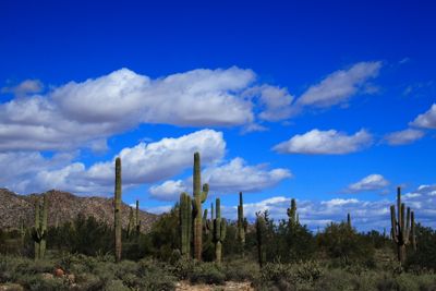
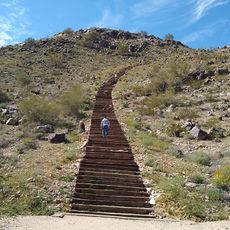
White Tank Mountain Regional Park covers about 30,000 acres with peaks reaching 4,000 feet and displays white granite formations with natural depressions. The terrain runs through several canyons that feature these distinctive white rocks and eroded water channels.

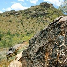
The land contains archaeological sites with remains of Hohokam settlements that thrived between 500 and 1100 CE in these canyons. These early desert dwellers developed ways to harvest and use the natural water resources found throughout the mountains.

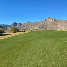
The landscape here reflects the Sonoran Desert ecosystem, where palo verde trees, ironwood, and various desert plants support native wildlife including bighorn sheep and roadrunners. Local communities have used these mountains for centuries as a place to connect with the natural environment.

The park offers more than 40 miles of trails for hiking and cycling at various difficulty levels. Visiting hours vary by season, so it is best to check exact opening times before heading out.

The tanks that give the park its name were carved by flash floods over thousands of years, hollowing out the white granite into natural water basins. These water-collection features remained essential to life in the desert and remain visible along several canyons today.

Location: Maricopa County

Location: Arizona

Opening Hours: Monday-Sunday 01:00-October 31-05:00-21:00; October 31-05:,April 30-06: Monday-Sunday 01:00-April 30-06:00-20:00

Phone: +6025062930

Website: https://maricopacountyparks.net/park-locator/white-tank-mountain-regional-park

GPS coordinates: 33.58833,-112.57361

Latest update: December 8, 2025 19:57

Photos
Around this place
State Farm Stadium
United States of America

State Farm Stadium

29.6 km
Phoenix Raceway
United States of America

Phoenix Raceway

34.1 km
Desert Sky Pavilion
United States of America

Desert Sky Pavilion

34.2 km
Wet'n'Wild Phoenix
United States of America

Wet'n'Wild Phoenix

41 km
White Tank Mountains
United States of America

White Tank Mountains

1.5 km
Wildlife World Zoo
United States of America

Wildlife World Zoo

15.5 km
New Waddell Dam
United States of America

New Waddell Dam

40.5 km
Phoenix Arizona Temple
United States of America

Phoenix Arizona Temple

39.2 km
Deer Valley Petroglyph Preserve
United States of America

Deer Valley Petroglyph Preserve

41.4 km
Manistee Ranch
United States of America

Manistee Ranch

37.7 km
Sahuaro Ranch
United States of America

Sahuaro Ranch

35.6 km
Cartwright Elementary School District
United States of America

Cartwright Elementary School District

38 km
Hassayampa River Preserve
United States of America

Hassayampa River Preserve

40.6 km
Sun Bowl Amphitheatre
United States of America

Sun Bowl Amphitheatre

26.2 km
Hassayampa Bridge
United States of America

Hassayampa Bridge

30 km
Glendale Veterans War Memorial
United States of America

Glendale Veterans War Memorial

35.9 km
First Methodist Episcopal Church of Glendale
United States of America

First Methodist Episcopal Church of Glendale

36.4 km
Victory Steps at Verrado
United States of America

Victory Steps at Verrado

10.1 km
Urban Air Trampoline and Adventure Park
United States of America

Urban Air Trampoline and Adventure Park

22.2 km
Wigwam Resort
United States of America

Wigwam Resort

22.8 km
Floralcroft Historic District
United States of America

Floralcroft Historic District

36.1 km
Sterling Grove Golf Course
United States of America

Sterling Grove Golf Course

12.7 km
Verrado Golf Club- The Victory Course 4242 North Golf Club Drive Buckeye AZ 85396
United States of America

Verrado Golf Club- The Victory Course 4242 North Golf Club Drive Buckeye AZ 85396

10.3 km
Mattel Adventure Park
United States of America

Mattel Adventure Park

29.5 km
Peoria Theatre
United States of America

Peoria Theatre

31.1 km
Avon Theatre
United States of America

Avon Theatre

26.9 km
Glendale Main Library
United States of America

Glendale Main Library

35.9 km
Agua Fria River Bridge
United States of America

Agua Fria River Bridge

25.1 km
Show the full map
Reviews

Visited this place? Tap the stars to rate it and share your experience / photos with the community! Try now! You can cancel it anytime.

« White Tank Mountain Regional Park - Regional park in Maricopa County, US » is provided by Around Us (aroundus.com). Images and texts are derived from Wikimedia project under a Creative Commons license. You are allowed to copy, distribute, and modify copies of this page, under the conditions set by the license, as long as this note is clearly visible.

Discover hidden gems everywhere you go!

From secret cafés to breathtaking viewpoints, skip the crowded tourist spots and find places that match your style. Our app makes it easy with voice search, smart filtering, route optimization, and insider tips from travelers worldwide. Download now for the complete mobile experience.

Around Us App Screenshot

A unique approach to discovering new places

Le Figaro

All the places worth exploring

France Info

A tailor-made excursion in just a few clicks

20 Minutes