Enable Location

We need your location to show you interesting places around you

Discover nearby places

Find interesting locations and hidden gems around you

Precise directions

Get accurate directions and distances to places

Your location is never shared with other users. It's only used when you tap the location button.

Hassayampa Bridge

Log in to your account

Start exploring — it's free

Trusted by 62,560 travelers worldwide

Continue with Google
Continue with Apple
or

We will send you a code to connect

By continuing, you accept our Terms and Conditions and our Privacy Policy

Check your inbox

We've sent a pincode in your inbox. Please enter the code below.

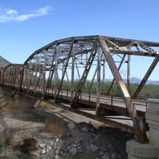
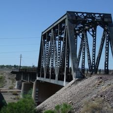
Hassayampa Bridge, Road bridge in Maricopa County, Arizona.

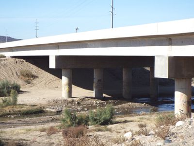
Hassayampa Bridge is a road bridge built in 1929 across the Hassayampa River in Maricopa County. It has seven concrete spans, each roughly 45 feet long, and carries vehicle traffic on an asphalt-over-concrete deck.

The bridge was constructed in 1929 by the firm Strong and Grant from Springville, Utah. It replaced an earlier timber crossing from 1915 that had originally served this river passage.

The structure displays design elements typical of the 1920s, with its four-rib concrete construction and molded concrete railings. These details reflect engineering methods that were common across the United States during that era.

The bridge is located on Old U.S. Highway Route 80 and is accessible to regular vehicle traffic. Since it is a historic structure on a roadway, visitors should drive carefully and be aware of traffic conditions.

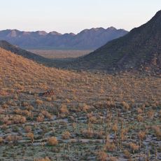
This crossing served as a critical point on Arizona's most traveled highway at the time and helped eliminate a major barrier to regional commerce. Its location on this historic route made it an important hub for the region's economic growth.

The community of curious travelers

AroundUs brings together thousands of curated places, local tips, and hidden gems, enriched daily by 60,000 contributors worldwide.

Start exploring
Location
Location
Inception
1929
GPS coordinates
33.34833,-112.72139
Latest update
December 14, 2025 18:14
Around this place
State Farm Stadium
United States of America

State Farm Stadium

47.1 km
Phoenix Raceway
United States of America

Phoenix Raceway

38.3 km
Desert Sky Pavilion
United States of America

Desert Sky Pavilion

47.4 km
White Tank Mountains
United States of America

White Tank Mountains

28.6 km
Sonoran Desert National Monument
United States of America

Sonoran Desert National Monument

48.3 km
Wildlife World Zoo
United States of America

Wildlife World Zoo

36.3 km
Painted Rock Petroglyph Site
United States of America

Painted Rock Petroglyph Site

47.3 km
White Tank Mountain Regional Park
United States of America

White Tank Mountain Regional Park

30 km
Gillespie Dam Highway Bridge
United States of America

Gillespie Dam Highway Bridge

14.2 km
Sahuaro Ranch
United States of America

Sahuaro Ranch

55.5 km
Cartwright Elementary School District
United States of America

Cartwright Elementary School District

51.9 km
Phoenix Air Defense Sector
United States of America

Phoenix Air Defense Sector

40.2 km
Sugarloaf Mountain
United States of America

Sugarloaf Mountain

47.8 km
Sun Bowl Amphitheatre
United States of America

Sun Bowl Amphitheatre

47.4 km
Gatlin Site
United States of America

Gatlin Site

40.3 km
First Methodist Episcopal Church of Glendale
United States of America

First Methodist Episcopal Church of Glendale

54.2 km
Sachs-Webster House
United States of America

Sachs-Webster House

46.7 km
Laveen School Auditorium
United States of America

Laveen School Auditorium

51.5 km
Wigwam Resort
United States of America

Wigwam Resort

38.4 km
Floralcroft Historic District
United States of America

Floralcroft Historic District

54.1 km
Sterling Grove Golf Course
United States of America

Sterling Grove Golf Course

37.6 km
Gila Bend Visitor Center and Museum
United States of America

Gila Bend Visitor Center and Museum

44.9 km
Peoria Theatre
United States of America

Peoria Theatre

51.8 km
Stout's Hotel
United States of America

Stout's Hotel

44.6 km
Avon Theatre
United States of America

Avon Theatre

36 km
Glendale Main Library
United States of America

Glendale Main Library

55.8 km
Agua Fria River Bridge
United States of America

Agua Fria River Bridge

48.3 km
Rocky Point
United States of America

Rocky Point

51.5 km
Show the full map
« Hassayampa Bridge - Road bridge in Maricopa County, Arizona » is provided by Around Us (aroundus.com). Images and texts are derived from Wikimedia project under a Creative Commons license. You are allowed to copy, distribute, and modify copies of this page, under the conditions set by the license, as long as this note is clearly visible.

Discover hidden gems everywhere you go!

From secret cafés to breathtaking viewpoints, skip the crowded tourist spots and find places that match your style. Our app makes it easy with voice search, smart filtering, route optimization, and insider tips from travelers worldwide. Download now for the complete mobile experience.

Around Us App Screenshot

A unique approach to discovering new places

Le Figaro

All the places worth exploring

France Info

A tailor-made excursion in just a few clicks

20 Minutes

Around Us
Travel Guide & Maps
Download

Send to your phone

QR Code
1

Open the camera app on your mobile.

2

Point at the QR code with your camera. A notification will appear.

3

Tap the notification to open the link.