Enable Location

We need your location to show you interesting places around you

Discover nearby places

Find interesting locations and hidden gems around you

Precise directions

Get accurate directions and distances to places

Your location is never shared with other users. It's only used when you tap the location button.

Gillespie Dam Highway Bridge

Log in to your account

Join the adventure

Create your free account and start exploring (like 60k+ others)

We will send you a code to connect

or
Continue with Google
Continue with Apple
By continuing, you accept our Terms and Conditions and our Privacy Policy

Check your inbox

We've sent a pincode in your inbox. Please enter the code below.

Gillespie Dam Highway Bridge

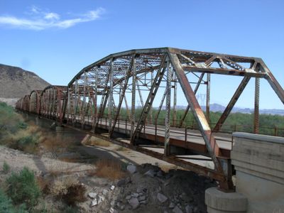
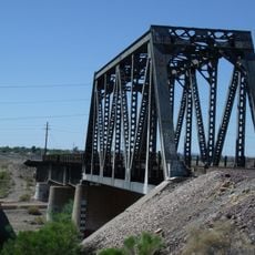
Gillespie Dam Highway Bridge, Steel truss bridge along Old US 80 Highway in Maricopa County, Arizona.

Description

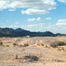
The Gillespie Dam Highway Bridge is a steel truss bridge crossing the Gila River with nine spans supported by concrete abutments anchored in bedrock. The structure stretches approximately 500 meters across the desert landscape along what was once a major highway.

History

This bridge was completed in 1927 and formed part of the original Route 80, a major transcontinental highway connecting the Pacific coast to the Atlantic. The route shifted away from this location in 1956 as transportation networks evolved.

Culture

The bridge stands as an engineering achievement from the early automotive era and has been recognized in the National Register of Historic Places since 1981. It represents how communities marked important transportation routes with enduring structures.

Practical

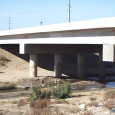
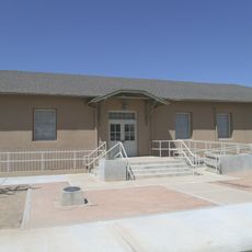
The bridge is accessible to visitors who want to explore this historical route, and an interpretive center on-site provides information about its history and engineering. Access is easiest from the nearby towns of Arlington or Gila Bend in either direction.

Did you know?

The bridge features a distinctive Camelback truss design that has proven its resilience during several major flooding events in the region. This design allowed the structure to withstand powerful surges of water without suffering significant damage.

Location
GPS coordinates
33.22728,-112.76943
Latest update
December 8, 2025 19:49

AroundUs brings together thousands of curated places, local tips, and hidden gems, enriched daily by 60,000 contributors worldwide. Discover all places nearby (Maricopa County).

Around this place
State Farm Stadium
United States of America

State Farm Stadium

57.8 km
Phoenix Raceway
United States of America

Phoenix Raceway

45.7 km
Desert Sky Pavilion
United States of America

Desert Sky Pavilion

56.8 km
White Tank Mountains
United States of America

White Tank Mountains

42.7 km
Sonoran Desert National Monument
United States of America

Sonoran Desert National Monument

37.4 km
Wildlife World Zoo
United States of America

Wildlife World Zoo

48.8 km
Painted Rock Petroglyph Site
United States of America

Painted Rock Petroglyph Site

34.5 km
White Tank Mountain Regional Park
United States of America

White Tank Mountain Regional Park

44.1 km
Main Event
United States of America

Main Event

52.4 km
Cartwright Elementary School District
United States of America

Cartwright Elementary School District

61.2 km
Phoenix Air Defense Sector
United States of America

Phoenix Air Defense Sector

52 km
Isanaklesh Peaks
United States of America

Isanaklesh Peaks

50.3 km
Sugarloaf Mountain
United States of America

Sugarloaf Mountain

56.6 km
Eagletail Mountains Wilderness
United States of America

Eagletail Mountains Wilderness

63.3 km
Sun Bowl Amphitheatre
United States of America

Sun Bowl Amphitheatre

59.2 km
Gatlin Site
United States of America

Gatlin Site

27.5 km
Hassayampa Bridge
United States of America

Hassayampa Bridge

14.2 km
Sachs-Webster House
United States of America

Sachs-Webster House

53.7 km
Del Monte Market
United States of America

Del Monte Market

62.5 km
Laveen School Auditorium
United States of America

Laveen School Auditorium

57.9 km
Wigwam Resort
United States of America

Wigwam Resort

49.5 km
Sterling Grove Golf Course
United States of America

Sterling Grove Golf Course

50.7 km
Gila Bend Visitor Center and Museum
United States of America

Gila Bend Visitor Center and Museum

31.7 km
Peoria Theatre
United States of America

Peoria Theatre

63.1 km
Stout's Hotel
United States of America

Stout's Hotel

31.5 km
Avon Theatre
United States of America

Avon Theatre

45.5 km
Agua Fria River Bridge
United States of America

Agua Fria River Bridge

60.5 km
Rocky Point
United States of America

Rocky Point

39.6 km
Show the full map
« Gillespie Dam Highway Bridge - Steel truss bridge along Old US 80 Highway in Maricopa County, Arizona » is provided by Around Us (aroundus.com). Images and texts are derived from Wikimedia project under a Creative Commons license. You are allowed to copy, distribute, and modify copies of this page, under the conditions set by the license, as long as this note is clearly visible.

Discover hidden gems everywhere you go!

From secret cafés to breathtaking viewpoints, skip the crowded tourist spots and find places that match your style. Our app makes it easy with voice search, smart filtering, route optimization, and insider tips from travelers worldwide. Download now for the complete mobile experience.

Around Us App Screenshot

A unique approach to discovering new places

Le Figaro

All the places worth exploring

France Info

A tailor-made excursion in just a few clicks

20 Minutes

Around Us
Travel Guide & Maps
Download

Send to your phone

QR Code
1

Open the camera app on your mobile.

2

Point at the QR code with your camera. A notification will appear.

3

Tap the notification to open the link.