Ciénega Bridge

Log in to your account

AroundUs is a community-driven map of interesting places, built by curious explorers like you. It grows with every review, story, and photo you share.
Connect to save your favorite spots, contribute locations, and create personalized routes.
By continuing, you accept our Terms and Conditions and our Privacy Policy
Add to collection
Map
Suggest a change
Share

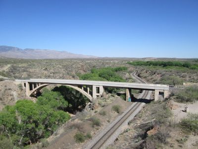
Ciénega Bridge, Concrete arch bridge in Pima County, Arizona
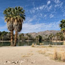
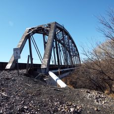
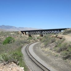
The Ciénega Bridge spans 278 feet across Ciénega Creek and the Union Pacific Railroad tracks with five concrete spans and twin tapered ribs.

The Arizona Highway Department completed the construction of Ciénega Bridge in March 1921 at a cost of 40,000 dollars after taking over from the initial contractor.

The bridge represents early 20th-century transportation infrastructure development in Arizona, earning its place on the National Register of Historic Places in 1988.
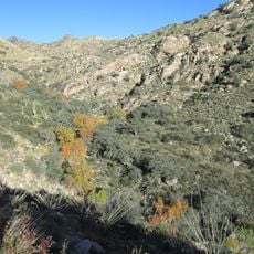
Visitors need to obtain a parking permit from Pima County Parks & Recreation at least two business days before accessing the bridge area.

The structure provides an observation point for approximately 40 daily trains, including double-stack containers, military units, and Amtrak's Sunset Limited service.

Location: Pima County

GPS coordinates: 32.01971,-110.64601

Latest update: March 4, 2025 14:42

Around this place
Show the full map
309th Aerospace Maintenance and Regeneration Group
United States of America

309th Aerospace Maintenance and Regeneration Group

22.9 km
Pima Air & Space Museum
United States of America

Pima Air & Space Museum

24.6 km
Kartchner Caverns State Park
United States of America

Kartchner Caverns State Park

34.8 km
Empire Ranch
United States of America

Empire Ranch

26.1 km
Colossal Cave
United States of America

Colossal Cave

5.2 km
Tucson Botanical Gardens
United States of America

Tucson Botanical Gardens

34.7 km
Reid Park Zoo
United States of America

Reid Park Zoo

33.3 km
Las Cienegas National Conservation Area
United States of America

Las Cienegas National Conservation Area

26.6 km
Pima Canyon
United States of America

Pima Canyon

33.4 km
Apache Peak
United States of America

Apache Peak

29.9 km
Agua Caliente Regional Park
United States of America

Agua Caliente Regional Park

30.3 km
Molino Canyon
United States of America

Molino Canyon

34.6 km
Manning Cabin
United States of America

Manning Cabin

22.6 km
Benson Railroad Historic District
United States of America

Benson Railroad Historic District

33.6 km
Apache Powder Historic Residential District
United States of America

Apache Powder Historic Residential District

33.2 km
Programa de las Leguminosas del Desierto
United States of America

Programa de las Leguminosas del Desierto

17.6 km
Saguaro Wilderness
United States of America

Saguaro Wilderness

20.7 km
San Pedro Golf Course
United States of America

San Pedro Golf Course

34.4 km
Colonia Solana Residential Historic District
United States of America

Colonia Solana Residential Historic District

34.1 km
Ignite Sign Art Museum
United States of America

Ignite Sign Art Museum

35.5 km
The Historic Aviation Bone Yard
United States of America

The Historic Aviation Bone Yard

23 km
Rincon Mountain Visitor Center
United States of America

Rincon Mountain Visitor Center

19.8 km
Saint Joseph church in Tucson
United States of America

Saint Joseph church in Tucson

30.6 km
Saint Cyril of Alexandria church in Tucson
United States of America

Saint Cyril of Alexandria church in Tucson

33.7 km
Aerospace Maintenance and Regeneration Center
United States of America

Aerospace Maintenance and Regeneration Center

22.9 km
San Pedro chapel capillita in Tucson
United States of America

San Pedro chapel capillita in Tucson

34.8 km
San Pedro River Railroad Bridge
United States of America

San Pedro River Railroad Bridge

35.2 km
Marsh Station Bridge
United States of America

Marsh Station Bridge

61 m
Show the full map

Reviews

Visited this place? Tap the stars to rate it and share your experience / photos with the community! Try now! You can cancel it anytime.

« Ciénega Bridge: Concrete arch bridge in Pima County, Arizona » is provided by Around Us (aroundus.com). Images and texts are derived from Wikimedia project under a Creative Commons license. You are allowed to copy, distribute, and modify copies of this page, under the conditions set by the license, as long as this note is clearly visible.

Discover hidden gems everywhere you go!

From secret cafés to breathtaking viewpoints, skip the crowded tourist spots and find places that match your style. Our app makes it easy with voice search, smart filtering, route optimization, and insider tips from travelers worldwide. Download now for the complete mobile experience.

Around Us App Screenshot

A unique approach to discovering new places

Le Figaro

All the places worth exploring

France Info

A tailor-made excursion in just a few clicks

20 Minutes