Enable Location

We need your location to show you interesting places around you

Discover nearby places

Find interesting locations and hidden gems around you

Precise directions

Get accurate directions and distances to places

Your location is never shared with other users. It's only used when you tap the location button.

Biosphere 2

Log in to your account

Start exploring — it's free

Trusted by travelers worldwide

Continue with Google
Continue with Apple
or

We will send you a code to connect

By continuing, you accept our Terms and Conditions and our Privacy Policy

Check your inbox

We've sent a pincode in your inbox. Please enter the code below.

Biosphere 2

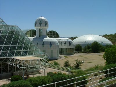
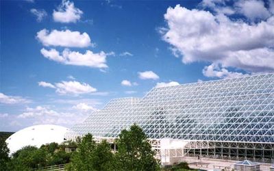
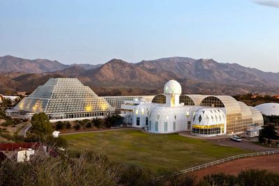
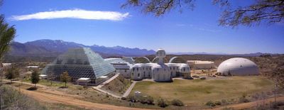
Biosphere 2, Artificial biosphere in Oracle, Arizona

Description

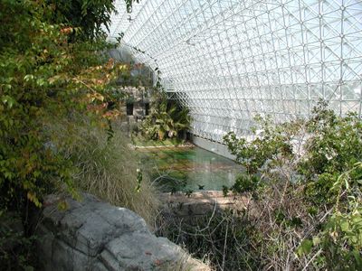
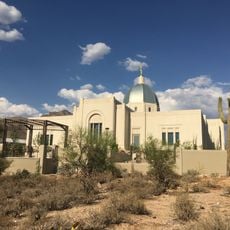
Biosphere 2 is a research facility in Oracle, Arizona, that contains multiple enclosed ecosystems under a glass dome. The complex covers about 3 acres (1.3 hectares) and includes a rainforest, an artificial ocean, a desert, mangrove wetlands, and a savanna environment.

History

The facility was completed in 1991 and initially hosted an experiment where eight people lived inside for two years to study closed ecological systems. Since the late 1990s, the University of Arizona has used it for climate and environmental research.

Culture

The center welcomes school groups and adults who want to learn about environmental research, offering guided walks through the different ecosystems. Visitors often see researchers working in the greenhouses and labs, which gives a direct look at how science happens here day by day.

Practical

Visitors usually explore the site on their own, guided by a mobile app that explains ongoing research and the different zones inside. The walkways pass through climate-controlled areas with high humidity in the rainforest section and drier zones, so light clothing and water are helpful.

Did you know?

During the first mission, the agricultural zone grew more than 80 percent of the food needed by the crew, including bananas, papayas, and sweet potatoes. The team had to harvest, process, and store everything on site, which gave an unusually close look at self-contained food systems.

Location
Inception
1991
GPS coordinates
32.57878,-110.85059
Latest update
December 12, 2025 19:30

AroundUs brings together thousands of curated places, local tips, and hidden gems, enriched daily by 60,000 contributors worldwide. Discover all places nearby (Arizona).

Around this place
Sabino Canyon
United States of America

Sabino Canyon

29.3 km
Catalina State Park
United States of America

Catalina State Park

16.7 km
Mount Lemmon Observatory
United States of America

Mount Lemmon Observatory

16.3 km
Peppersauce Cave
United States of America

Peppersauce Cave

14.8 km
DeGrazia Gallery in the Sun Historic District
United States of America

DeGrazia Gallery in the Sun Historic District

28.8 km
Tohono Chul
United States of America

Tohono Chul

29.3 km
Tucson Arizona Temple
United States of America

Tucson Arizona Temple

28.3 km
Camp Grant
United States of America

Camp Grant

32 km
Oracle State Park
United States of America

Oracle State Park

25.5 km
United States of America

Bear Canyon

29.9 km
Cactus Springs
United States of America

Cactus Springs

34.2 km
Acadia Ranch
United States of America

Acadia Ranch

8.7 km
Catalina Station
United States of America

Catalina Station

21.1 km
Tohono Chul | Gardens, Galleries, and Bistro
United States of America

Tohono Chul | Gardens, Galleries, and Bistro

29.3 km
Agua Caliente Regional Park
United States of America

Agua Caliente Regional Park

34.9 km
Thimble Peak
United States of America

Thimble Peak

27.8 km
La Casa del High Jinks
United States of America

La Casa del High Jinks

10.6 km
Romero Canyon
United States of America

Romero Canyon

16.7 km
Molino Canyon
United States of America

Molino Canyon

31.4 km
Pusch Ridge Wilderness Area
United States of America

Pusch Ridge Wilderness Area

22.7 km
St. Philip's in the Hills Episcopal Church
United States of America

St. Philip's in the Hills Episcopal Church

33.4 km
Lowell Ranger Station
United States of America

Lowell Ranger Station

30 km
Lemmon Rock Lookout House
United States of America

Lemmon Rock Lookout House

17 km
Soldier Trail Trailhead
United States of America

Soldier Trail Trailhead

31.9 km
SaddleBrooke One
United States of America

SaddleBrooke One

5.5 km
Church of Saint Thomas the Apostle in Tucson
United States of America

Church of Saint Thomas the Apostle in Tucson

31.8 km
Mammoth Wash Trestle Bridge
United States of America

Mammoth Wash Trestle Bridge

23.2 km
Drexel House
United States of America

Drexel House

31.1 km
Show the full map
« Biosphere 2 - Artificial biosphere in Oracle, Arizona » is provided by Around Us (aroundus.com). Images and texts are derived from Wikimedia project under a Creative Commons license. You are allowed to copy, distribute, and modify copies of this page, under the conditions set by the license, as long as this note is clearly visible.

Discover hidden gems everywhere you go!

From secret cafés to breathtaking viewpoints, skip the crowded tourist spots and find places that match your style. Our app makes it easy with voice search, smart filtering, route optimization, and insider tips from travelers worldwide. Download now for the complete mobile experience.

Around Us App Screenshot

A unique approach to discovering new places

Le Figaro

All the places worth exploring

France Info

A tailor-made excursion in just a few clicks

20 Minutes

Around Us
Travel Guide & Maps
Download

Send to your phone

QR Code
1

Open the camera app on your mobile.

2

Point at the QR code with your camera. A notification will appear.

3

Tap the notification to open the link.