Enable Location

We need your location to show you interesting places around you

Discover nearby places

Find interesting locations and hidden gems around you

Precise directions

Get accurate directions and distances to places

Your location is never shared with other users. It's only used when you tap the location button.

Mount Lemmon

Log in to your account

Start exploring — it's free

Trusted by 68,261 travelers worldwide

Continue with Google
Continue with Apple
or

We will send you a code to connect

By continuing, you accept our Terms and Conditions and our Privacy Policy

Check your inbox

We've sent a pincode in your inbox. Please enter the code below.

Mount Lemmon
Discussion Reviews 2 Photos
65.2k Popularity

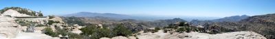
Mount Lemmon, Mountain peak in Coronado National Forest, Arizona.

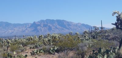
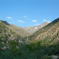
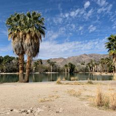
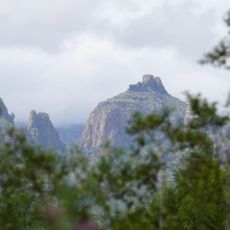
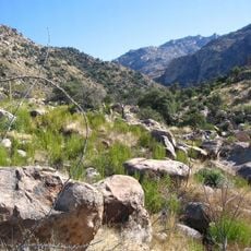
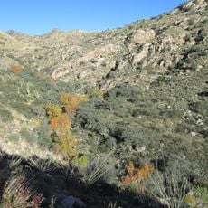
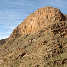
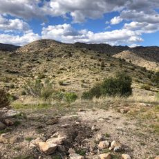
This peak in the Coronado National Forest of Arizona reaches 2,791 meters above sea level and consists of granite formations that define its ridges and slopes. The landscape shifts from dry desert flats to denser conifer forests as elevation increases, bringing cooler temperatures and different plant species.

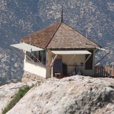
The summit received its name in honor of Sara Plummer Lemmon, a botanist who documented plant species in this area during an 1881 expedition. The road to the top was developed in the 1930s to provide access for recreation and fire control.

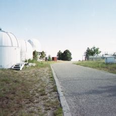
The SkyCenter takes advantage of dark skies and dry air for nighttime observation, offering programs that bring astronomy closer to visitors who come for the view. Clear conditions at this elevation attract both researchers and amateur stargazers working far from city lights.

The Catalina Highway winds upward on switchbacks and provides access to hiking trails, picnic areas, and camping spots along the way. Drivers in summer should bring warmer clothing, as temperature drops noticeably with elevation.

The drive upward passes through six distinct ecological zones, equivalent to a cross-section from Mexico to Canada, experienced within a few dozen kilometers. At the upper end sits the southernmost ski resort in the continental United States, allowing for snow activities during winter months.

The community of curious travelers

AroundUs brings together thousands of curated places, local tips, and hidden gems, enriched daily by 60,000 contributors worldwide.

Start exploring
Location
Made from material
granite
GPS coordinates
32.44313,-110.78843
Latest update
December 13, 2025 18:27
Around this place
Biosphere 2
United States of America

Biosphere 2

16.2 km
Sabino Canyon
United States of America

Sabino Canyon

14.3 km
Catalina State Park
United States of America

Catalina State Park

11 km
Mount Lemmon Observatory
United States of America

Mount Lemmon Observatory

137 m
Peppersauce Cave
United States of America

Peppersauce Cave

11.8 km
DeGrazia Gallery in the Sun Historic District
United States of America

DeGrazia Gallery in the Sun Historic District

16.6 km
Tohono Chul
United States of America

Tohono Chul

21.5 km
Tucson Arizona Temple
United States of America

Tucson Arizona Temple

19.1 km
United States of America

Bear Canyon

14.2 km
Cactus Springs
United States of America

Cactus Springs

24.1 km
Acadia Ranch
United States of America

Acadia Ranch

18.7 km
Catalina Station
United States of America

Catalina Station

6 km
Tohono Chul | Gardens, Galleries, and Bistro
United States of America

Tohono Chul | Gardens, Galleries, and Bistro

21.5 km
Golf 'n Stuff
United States of America

Golf 'n Stuff

22.8 km
Agua Caliente Regional Park
United States of America

Agua Caliente Regional Park

18.7 km
Thimble Peak
United States of America

Thimble Peak

11.9 km
La Casa del High Jinks
United States of America

La Casa del High Jinks

15 km
Romero Canyon
United States of America

Romero Canyon

9.4 km
Molino Canyon
United States of America

Molino Canyon

15.4 km
Pusch Ridge Wilderness Area
United States of America

Pusch Ridge Wilderness Area

8.8 km
St. Philip's in the Hills Episcopal Church
United States of America

St. Philip's in the Hills Episcopal Church

22.5 km
The Mini Time Machine Museum
United States of America

The Mini Time Machine Museum

22.2 km
Lowell Ranger Station
United States of America

Lowell Ranger Station

15 km
Lemmon Rock Lookout House
United States of America

Lemmon Rock Lookout House

919 m
Soldier Trail Trailhead
United States of America

Soldier Trail Trailhead

15.8 km
SaddleBrooke One
United States of America

SaddleBrooke One

13.4 km
Church of Saint Thomas the Apostle in Tucson
United States of America

Church of Saint Thomas the Apostle in Tucson

19.4 km
Drexel House
United States of America

Drexel House

20 km
Show the full map
Reviews
Share your experience

No review yet

Discussions
Start a discussion...

No discussion yet

« Mount Lemmon - Mountain peak in Coronado National Forest, Arizona » is provided by Around Us (aroundus.com). Images and texts are derived from Wikimedia project under a Creative Commons license. You are allowed to copy, distribute, and modify copies of this page, under the conditions set by the license, as long as this note is clearly visible.

Discover hidden gems everywhere you go!

From secret cafés to breathtaking viewpoints, skip the crowded tourist spots and find places that match your style. Our app makes it easy with voice search, smart filtering, route optimization, and insider tips from travelers worldwide. Download now for the complete mobile experience.

Around Us App Screenshot

A unique approach to discovering new places

Le Figaro

All the places worth exploring

France Info

A tailor-made excursion in just a few clicks

20 Minutes

Around Us
Travel Guide & Maps
Download

Send to your phone

QR Code
1

Open the camera app on your mobile.

2

Point at the QR code with your camera. A notification will appear.

3

Tap the notification to open the link.