Chest opened
+${chestReward.xp} XP
Explorer
NOUVEAU ×${chestReward.collectible.quantity}
tapez pour fermer
Chest locked

Open chests in the app

Around Us is built for your phone — chests unlock when you walk, explore and capture nearby places.

Enable Location

We need your location to show you interesting places around you

Discover nearby places

Find interesting locations and hidden gems around you

Precise directions

Get accurate directions and distances to places

Your location is never shared with other users. It's only used when you tap the location button.

Superstition Mountains

Log in to your account

Start exploring — it's free

Trusted by 72,889 travelers worldwide

Continue with Google
Continue with Apple
or

We will send you a code to connect

By continuing, you accept our Terms and Conditions and our Privacy Policy

Check your inbox

We've sent a pincode in your inbox. Please enter the code below.

Superstition Mountains
Discussion Reviews 1 Photos
109k Popularity

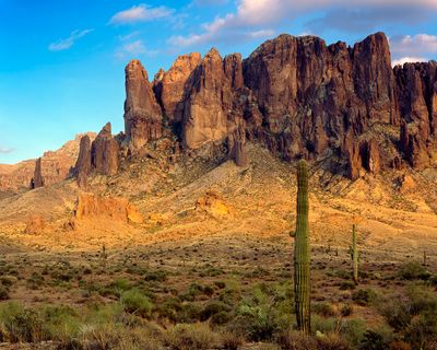
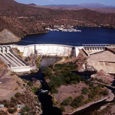
Superstition Mountains, Mountain range in East Mesa, Arizona.

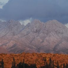
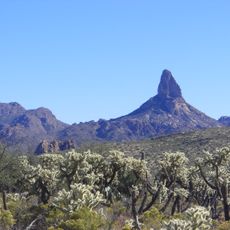
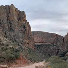
The Superstition Mountains rise roughly 1,500 meters (5,000 feet) above the Sonoran Desert and display volcanic rock formations with jagged peaks and saguaro cacti. The slopes consist of tuff and basalt, cut through by deep canyons filled with boulders and thorny shrubs.

Spanish explorers called the area Sierra de la Espuma in the 16th century before American prospectors arrived in the 19th century. The area gained federal wilderness protection in 1939, limiting further mining activities.

The name comes from Spanish tales about cursed areas that American settlers later adopted. Hikers today follow old paths through canyons while geologists study volcanic structures.

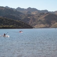
Several trailheads offer access to hiking paths of varying difficulty levels, with conditions changing by season. Early morning hours during spring or fall are recommended because of desert heat, and water must be carried.

A story about the lost gold mine of Jacob Waltz has drawn treasure hunters for over a century, though no one has located it. Warnings about snakes and extreme temperatures appear on all information boards at trailhead entrances.

The community of curious travelers

AroundUs brings together thousands of curated places, local tips, and hidden gems, enriched daily by 60,000 contributors worldwide.

Start exploring
Location
Elevation above the sea
1,542 m
GPS coordinates
33.47806,-111.23889
Latest update
December 12, 2025 22:52
Around this place
Theodore Roosevelt Lake
United States of America

Theodore Roosevelt Lake

23.1 km
Canyon Lake
United States of America

Canyon Lake

19.8 km
Lost Dutchman State Park
United States of America

Lost Dutchman State Park

22.2 km
Four Peaks
United States of America

Four Peaks

24.3 km
Saguaro Lake
United States of America

Saguaro Lake

28.5 km
Weaver's Needle
United States of America

Weaver's Needle

13.2 km
Skeleton Cave
United States of America

Skeleton Cave

16.7 km
Boyce Thompson Arboretum
United States of America

Boyce Thompson Arboretum

23.4 km
United States of America

Picketpost Mountain

25.8 km
Stewart Mountain Dam
United States of America

Stewart Mountain Dam

29.3 km
Mormon Flat Dam
United States of America

Mormon Flat Dam

20.7 km
Roosevelt Lake Bridge
United States of America

Roosevelt Lake Bridge

23.1 km
United States of America

Peralta Canyon

15.7 km
Our Lady of the Blessed Sacrament Church
United States of America

Our Lady of the Blessed Sacrament Church

35.1 km
Gold Canyon Golf Resort
United States of America

Gold Canyon Golf Resort

22.8 km
Miami Community Church
United States of America

Miami Community Church

35.6 km
Las Sendas Golf Club
United States of America

Las Sendas Golf Club

40 km
Tonto National Monument Visitor Center
United States of America

Tonto National Monument Visitor Center

22 km
Bullion Plaza Cultural Center and Museum
United States of America

Bullion Plaza Cultural Center and Museum

34.7 km
Sunland Springs Golf
United States of America

Sunland Springs Golf

35 km
Goldfield Ghost Town
United States of America

Goldfield Ghost Town

23.2 km
Apache Trail
United States of America

Apache Trail

29.4 km
Boulder Creek Bridge
United States of America

Boulder Creek Bridge

18.2 km
Pinto Creek Bridge
United States of America

Pinto Creek Bridge

29.3 km
Mormon Flat Bridge
United States of America

Mormon Flat Bridge

20.1 km
Alchesay Canyon Bridge
United States of America

Alchesay Canyon Bridge

22.4 km
Queen Creek Bridge
United States of America

Queen Creek Bridge

22.8 km
Mary Lou Fulton Aqauatic Center
United States of America

Mary Lou Fulton Aqauatic Center

39.6 km
Show the full map
Reviews
Share your experience

No review yet

Discussions
Start a discussion...

No discussion yet

« Superstition Mountains - Mountain range in East Mesa, Arizona » is provided by Around Us (aroundus.com). Images and texts are derived from Wikimedia project under a Creative Commons license. You are allowed to copy, distribute, and modify copies of this page, under the conditions set by the license, as long as this note is clearly visible.

Discover hidden gems everywhere you go!

From secret cafés to breathtaking viewpoints, skip the crowded tourist spots and find places that match your style. Our app makes it easy with voice search, smart filtering, route optimization, and insider tips from travelers worldwide. Download now for the complete mobile experience.

Around Us App Screenshot

A unique approach to discovering new places

Le Figaro

All the places worth exploring

France Info

A tailor-made excursion in just a few clicks

20 Minutes

Around Us
Travel Guide & Maps
Download

Send to your phone

QR Code
1

Open the camera app on your mobile.

2

Point at the QR code with your camera. A notification will appear.

3

Tap the notification to open the link.