Chest opened
+${chestReward.xp} XP
Explorer
NOUVEAU ×${chestReward.collectible.quantity}
tapez pour fermer
Chest locked

Open chests in the app

Around Us is built for your phone — chests unlock when you walk, explore and capture nearby places.

Enable Location

We need your location to show you interesting places around you

Discover nearby places

Find interesting locations and hidden gems around you

Precise directions

Get accurate directions and distances to places

Your location is never shared with other users. It's only used when you tap the location button.

Arizona State Route 87

Log in to your account

Start exploring — it's free

Trusted by 72,995 travelers worldwide

Continue with Google
Continue with Apple
or

We will send you a code to connect

By continuing, you accept our Terms and Conditions and our Privacy Policy

Check your inbox

We've sent a pincode in your inbox. Please enter the code below.

Arizona State Route 87
Discussion Reviews 1 Photos
16k Popularity

Arizona State Route 87, state highway in Arizona, United States

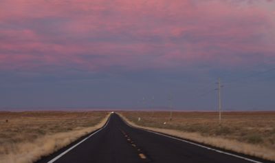
Arizona State Route 87 is a state highway in Arizona that runs from the southern part of the state all the way to the Hopi Reservation near Second Mesa. It crosses urban areas around Chandler and Coolidge, open desert stretches, and a mountain section north of Phoenix known as the Beeline Highway, where the road widens to four lanes.

The route was established in the 1920s as a basic connection to the mountains and was gradually improved over the following decades. A local figure named Harvey Bush was central to the push that brought a proper mountain road between Phoenix and Payson into existence.

The road passes through the Gila River Indian Community and approaches the Hopi Reservation near Second Mesa, where the land and local ways of life shape the surroundings. Drivers who slow down through these sections notice differences in roadside structures, signs, and how people use the space around them.

Cell phone coverage can be weak along long stretches of the road, so it helps to carry water and check the car before setting off. Some sections have uneven pavement, particularly in less developed parts, so drivers should stay alert.

Several different local governments are each responsible for their own section of the road, which gives it a slightly different look and feel depending on where you are. This arrangement reflects how the road grew over time, with each community taking on its own piece of the infrastructure as the route expanded northward.

The community of curious travelers

AroundUs brings together thousands of curated places, local tips, and hidden gems, enriched daily by 60,000 contributors worldwide.

Start exploring
Location
Inception
1927
GPS coordinates
34.26005,-111.32246
Latest update
March 3, 2026 08:20
Reviews
Share your experience

No review yet

Discussions
Start a discussion...

No discussion yet

« Arizona State Route 87 - state highway in Arizona, United States » is provided by Around Us (aroundus.com). Images and texts are derived from Wikimedia project under a Creative Commons license. You are allowed to copy, distribute, and modify copies of this page, under the conditions set by the license, as long as this note is clearly visible.

Discover hidden gems everywhere you go!

From secret cafés to breathtaking viewpoints, skip the crowded tourist spots and find places that match your style. Our app makes it easy with voice search, smart filtering, route optimization, and insider tips from travelers worldwide. Download now for the complete mobile experience.

Around Us App Screenshot

A unique approach to discovering new places

Le Figaro

All the places worth exploring

France Info

A tailor-made excursion in just a few clicks

20 Minutes

Around Us
Travel Guide & Maps
Download

Send to your phone

QR Code
1

Open the camera app on your mobile.

2

Point at the QR code with your camera. A notification will appear.

3

Tap the notification to open the link.